Ireland

Elements area

Taxonomy

Code

Scope note(s)

    Source note(s)

      Display note(s)

        Hierarchical terms

        Ireland

          Equivalent terms

          Ireland

            Associated terms

            Ireland

              8 Archival description results for Ireland

              8 results directly related Exclude narrower terms
              UGA P/P120/1/2/7/1 · Item
              Part of Personal

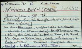
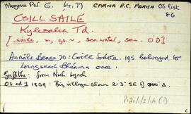
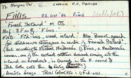
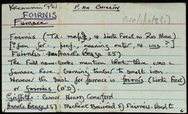
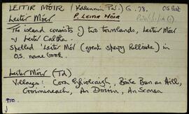
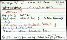
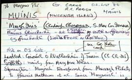
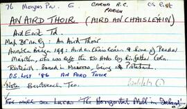
              Set of index cards describing some of the features of An Aird Thoir [Aire an Chaisleáin/Ard East]. Features described include Caisleán na hÁirde (Ard Castle on the OS maps), Tobar Cholm Cille, Caladh Cam, Carroll's Aquaculture (a salmon processing factory), Poll an Ghlas Oileáin, Cuainín na hAirde, Carraig Úna, Cuan na hÁirde, Loch na Faiche, Carraig Bhuí, Cora Locháin, Carraig na bhFaoileán, Glasoileán na bhFiagach, An Sián, Tadhg na Binle, Cora na hAirde, Cnocán Glas, Mulán an Mhathlaigh, Cara na hÁirde, Carraig an Ancaire, Bun an tSrutháin, Sálalaoí, glasoileán an Táilliúra, Crapmán an Chutair, An Carraig Léith, and An Troscain. J and M Giollamháirtín, and Séamus McDonncha credited with providing information.

              Robinson,Tim,McDonncha,Séamus,Giollamháirtín,Joe,Máirtín
              Bánrach Bhán (Theas)
              UGA P/P120/1/11/2/1 · Item
              Part of Personal

              Set of index cards detailing some of the local features of the townland of Bánrach Bhán Theas [Banraghbawn South]. Included are brief descriptions of Loch na Bantraí, Loch an Aibhnín (which a local man called Loch na nOileán and Loch Uachtar), and Tobar Cholm Cille.

              Robinson,Tim
              Coill Sáile
              UGA P/P120/1/2/14/1 · Item
              Part of Personal

              Set of index cards describing some of the features of the townland of Coill Sáile [Kylesalia]. Features described include Carraig an Chomair, Crompán Choille Sáile, Sruthán na mBrácaí, An Chara Dhubh, Flannery Bridge, Cloch na dTaibhsí, An Garraí Graf, An Meall, Crompán Thaidhg na Buile, Na Caisleáin, Cora Ró Dúgáin, Meall Gorm, Ros Cam, Crompán Lannach, Aill Uaithne, An Criathrach Mór, Loch na Teorann, Cloch Ádhbhach, Ros Dubhgáin, and Tobar Cholm Cille. Pat Sullivan, Professor Seán de Courcy, Seán Dundass, Pádraic MacDonncha, and Máire Canavan all credited with providing information.

              Robinson,Tim,Sullivan,Pat,Courcy,Seán de,Dundass,Seán,MacDonncha,Pádraic,Canavan,Máire
              Fínis
              UGA P/P120/1/2/19/1 · Item
              Part of Personal

              Set of index cards describing some of the features of the townland of Fínis [Finish Island]. Some information from the Field Name Books, and derived from local lore about there being a burial ground for children and strangers in the centre of the island. Included in the descriptions are Trá Theach na Scoile, Tóin an Oileáin, An Gearrán, Carraig Bháird, Mullán an Róin, Trá na Leaca, Na hAnlacain, Béal na Trá, An Trá Mhóir, Trá na Muice, Trá an Uisce, Trá Bhun an Chlaí, Trá Dhubháinín, An Mhuic Ghainimh, Carraig Sheáin Uí Fheinne, Carraig Chrochúif, Carraig Éamainn, An Mhuc Ghainimh (referred to as 'Feenish Spit' on an Admiralty Chart), An Leachta, Carraig an tSeoigigh (Joyce's rock), Cora Phádraic Con Rí, Trá Thulach Thirin, An Clo' Bhuaile, Trá Bheag, Céibh an Chalaidh Mhóir, Trá na bhFataí Biata, Bóthar na Scoláire, Trá na Mumhan (a possible reference to settlers from Co. Clare), Leacracha Mhuintir Churraidhin (named after three Cill Chiaráin men who drowned), Poll na Sean-toinne, and Tobar Cholm Cille (an anecdote from Coilín MacDonncha included here, in Irish). Some local people credited with provding information, these are named as Coilín MacDonncha, S Ó'Ceoinín, P de Búrca, and E. Ó'Néill.

              Robinson,Tim,MacDonncha,Coilín,Ó'Ceoinín,S.,Búrca,P. de,Ó'Néill,E.
              Foirnis
              UGA P/P120/1/10/8/1 · Item
              Part of Personal

              Set of index cards detailing some of the local features of the townland of Foirnis, [Furnace Island]. Once a hub of poitín production, until two men tragically drowned on their way back from Oileán Dá Bruitneog. Brief descriptions are included of Crompán na Teorann, Tobar Cholm Cille, Crompán an Mhaide Mhóir, Cuan Chaisín, Oileán Chaisín, Oileán an Arbhair, Céibh Nua, Céibhín Choilín, Lochán na bhFroganna, Aill Chuigéal Bheag, Leic an Chlíarach, Balla Shadhbh, Cnocán an Rúscaire, Garbhcharraig, Aill na Máistreás, Cnocán an Phréachán, Crocán Dóite, Tigh Bhridín Uí Dhireáin, Aill Chaisín, An Dumhaigh, Crompan Spáinneach, Coisméig na Caillí, Clochar na bPáistí, Crompán na Dumhaí, Bealach Leithéan, and An Chuigéal Bheag. P. de Bhaldraithe, P. O'Maoilchiaráin, and Tom Folan are credited as providing some of the information for this townland.

              Robinson,Tim,Bhaldraithe,P. de,O'Maoilchiaráin,P.,Folan,Tom
              Leitir Móir
              UGA P/P120/1/11/14/1 · Item
              Part of Personal

              An index card devoted to the townland of Leitir Móir, [Lettermore]. Leitir Móir and Leitir Caltha (Leitir Calaidh) are on the same island. Christopher St. George was the lessor at the time of Griffith's Valuation. A note on An Teach Mór, Inishbay, Oileán Gorm, An Muirbheach, Carraig na Láibe, the local church built in 1958, Céibh Leitir Móir, Cora Ghiolca, An Doirín Glas, An Sconsa, Droichead Carraig an Lugáin, Céibh an Sconsa, Croimineach, Bun an Fháil, Lettermore House, Cuan an Doirín Glas, Oileán na dTráchta, Céibh na Leice, Tobar Cholm Cille, Oileán an Ghréasaí, Carraig an Iolra, Cnoc Leitir Lóir, Brandy Harbour, An Tráchta, and Céibh na dTráchta. N. Ó'Conchubhair, Tomás Ó'Conghaile, and Claire Ní Tuathail are credited as being local sources of information.

              Robinson,Tim,Ó'Conchubhair,N.,Ó'Conghaile,Tomás,Ní Tuathail,Claire
              Leitreach Árd
              UGA P/P120/1/2/27/1 · Item
              Part of Personal

              Set of index cards describing the local features of the townland of Leitreach Ard, [Letterard]. Information from Griffith's Valuation, and from the sale of the Martin Estate in 1849 about large tenants and ownership. A note in the pronunciation, to say the people of the townland call it Leitir Ard, but Carna people call it Leitreach Ard. A note on the McDonagh family (Clann Donnchada na Céise, not Clann Donnchada an Teistúin). A description of Demesne Lodge, close to McDonagh's House on Nimmo's 19th century map. Other features described include Loch na Scinín, Loch Tanaí, Loch Pháidín Rua, Loch an tSnámh (Lough Dereenaniurla on the OS maps), Loch Ghleann an tStrutháin, Loch na Calgaí, Rosenure Harbour, Fraochoileán, Crompán Leitreach Ard, Maidhm Beag, Aill Bríd Ní Chaonaigh, Aill an Dá Bhinn (Aildaveen on Nimmo's map, and some notes describing the local people's interpretations of the placename), An Cathaoir, Aill an Bhindéil, Béal Chara, Talamh Ghairbh, Ard Garraí na bPoll, Cnocán na nUibheachaí, Bóithrín an Iarla, Leachta Mháire Ní Chionnaigh, Damhras, Tobar Cholm Cille, Damhras, Tobar Mhuire, Aill an Adhmaid, Leac na gCaorach, Aill Bhairbre Bheag, Mullán Sheáinín Jack, Aill na Móna, Píosa Pháidín Mhurchú, Gob na Nóinín, An Leic Mhór, Gleann an tSrutháin, Maidhm Smith, Doirín an Iarla, Inis Troigh, Cuan Caorthainm, Barret's Quay [Céibh Bairéad], and Bealach an tSoipín. Bedford's map, Pádraig Ó'Cadhla of Leitir Ard, Michael King of Inis Ní, Seosamh Ó'Dónall of Glinsce, Mary of Leitir Ard, Mrs Ridge of Leitir Ard, Tom Conneely, Josie Phádraig Cionnaigh of Leitir Ard, a Mrs McDonncha living locally, Matt Connolly of Leitir Ard, and P. Barrett were references consulted by Tim Robinson, all of whom are credited on the cards.

              Robinson,Tim,Ó'Cadhla,Pádraig,King,Michael,Ó'Dónall,Seosamh,Conneely,Tom,Cionnaigh,Josie Phádraig,Connolly,Matt,Barrett,B.
              Muínis
              UGA P/P120/1/2/34/1 · Item
              Part of Personal

              Set of index cards describing the local features of the townland of Muínis [Maínis on logainm.ie, translated into English as Mweenish Island]. Note about ambiguity between Moyrish and Muínis in Simington's 'Books of Survey and Distribution'. Included are descriptions of Feithearnach, Carraig na Blaodhaí, a detailed note on the Estate of Colonel Nolan, sitting MP for North Galway. An Chreig Mhóir, An Sián, a causeway, Trá na mBád, An Cuainín, Muc Ghainimh, Maidhm Mhairtín Thaidhg, Crompán an Chúir, Stupóg an Táilliúrn, Leathrach na mBran (a fishing spot), Leaba Dhiarmaid, Bhéard na gCathasach. An Cuan Mór, Poll an Chora, Aill Chaltha an Aifrinn, Aircín an Mhaide Rámhair, Rinn Bheiglach, Ardskillan, Cibh an Bhéartha, Trá na Dumhaí Bige, Trá Fhada, Leic an Mhuinigh, An Ard-Thrá, Maidhin Mhicil Bhuí, An Garraí Mór, Mweenish Lodge, Carraig an Gharraí Aird, Oileán Lachan (Duck Island on the OS maps), An Dumhach Fhionn, An Aircín Thoir, An tSáilín, Oileán an Chara, Aircín Thiar, Crompán an Liamháin, Tóin Roisín, Trá an Bhoilg, Trá Dheiscirt, An Trá Mhóir, Tobar Cholm Cille, Mac Con Iomaire, Tobar na Seacht nIníon (well of the seven daughters on the OS maps), Loch Varáin, Carraig na mBan, Inis tSruthair, Tonn Uí Floinn, Tóin Ghairbh, An Meall Rua, Cartúr, Portach Mhuínse, Carraig na bPortán, Tobar Cholm Cille, Garraí na nGéabha, Leic na Gharraí Ghainimh, Bóithrí na Trá, Na Corainneacha, Leic na Cora, Coréal Mheaircín, and Clochar an Mhadra Uisce. The word 'local' is written on several of the index cards, indicating that Tim Robinson would have spoken with members of the community, and taken their knowledge of places and spellings in compiling this information. Two individuals are named, Sgt. P O Conaola, and M King of Inis Ní. Several other sources are credited, including Brother Conal Thomas's book 'The Land for the People: The United Irish League and Land Reform in North Galway, 1898-1912', Liosta Focal, Chroí Chonamra, and Nimmo's 1825 map.

              Robinson,Tim,Conaola,P. O.,Sgt.,King,M.