Connemara

Elements area

Taxonomy

Code

Scope note(s)

    Source note(s)

      Display note(s)

        Hierarchical terms

        Connemara

          Equivalent terms

          Connemara

            Associated terms

            Connemara

              559 Archival description results for Connemara

              Addergoole
              UGA P/P120/1/3/2/1 · Item
              Part of Personal

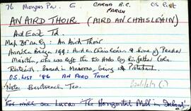
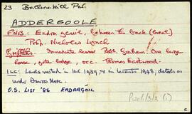
              Set of index cards describing some of the local features of the townland of Addergoole, [Eadargúil]. Included are descriptions of the National Park lands, in which he traces the ownership of the land since after the Famine, during which time it was part of the Martin Estate, the property of the Barrow and Calcutta Jute Company, James P Joyce, and currently the property of the OPW. Kylemore Farmhouse and yard are also described, with some detail on Addergoole Farm in the 19th and 20th centuries (a model farm, in which bogland was reclaimed, and the site of a turbine which powered a local sawmill). Tullygwee Bridge (Tulaig Guide bridge over the Dawros River), Glencorbet, Meacanach (Muckanaght) are also described.

              Robinson,Tim
              Aill Bhreac
              UGA P/P120/1/5/1/1 · Item
              Part of Personal

              Set of index cards describing some of the local features of the townland of (An) Aill Bhreac, [Aillebrack]. Included among the set of cards are descriptions of Carraig an Lios (more familiar to locals as Carraig Áilis, or Ailice's rock, used as a place to bury children until 1803), Split Rock, Cnocán Breac (Guaire na bpáistide in the Field Name Book), Holy Well and Mass Rock, Cé Bhun Abhann, Maidhm Cromaill (Cromwell Shoal), Straw Beach Island, Loch Caffrey, Bóithrín Beag, Lochán Buí, Oileán Ura (Illaunurra), Loch an Doirín, Sand Lake, Dóilainn Harbour, Cnocán na hAille Brice, Horse Island, the Well of the Seven Daughters (sometimes known locally as the Well of the Seven Sisters), Midden, Creig, Carraig Cumair, Carraig an Ghamhna (Calf Island), Buachaill (Boughillcarrickcark/Bóchaill), Carraig an Locháin, Carrach an tSeoighe, Corrach an tSrutha, Corrán, Tóin an Rosa, Carraig an Fhuaruisce, the Coastguard Station, Murlach, For Buaile, the Children's Burial Ground, Carraig an Fhioruisce, Corrán Beag, and Corrán Mór. Seán King of Ballyconneely, Martin O'Malley of Roundstone, and local man Jim O'Malley are credited with providing some of the information.

              Robinson,Tim,O'Malley,Martin,King,Seán,Jim
              Aill na Caillí
              UGA P/P120/1/1/1/1 · Item
              Part of Personal

              Set of index cards describing the name, residents, geographical features, and monuments in Aill na Caillí [Aillenacally/Aillnacally]. Includes an account from a former resident that suggests the original name may have been Aill na Coille 'because of the little wood on the cliff'. Loch Mártain, the Holy Well, Cnocnán Mór, Cora Mór, The Pounds, Aill Mór, and The Green Island are all described. Peter Ward of Tuaim Beola [Toombeola] credited with providing some information.

              Robinson,Tim,Ward,Peter
              Aille
              UGA P/P120/1/11/24/1 · Item
              Part of Personal

              Set of index cards describing some of the local features of the townland of Aille, [Na hAille]. Notes are included on Gannaidh na ceanta, Dooletter, Tievegarriff, Ballyfanagh, Bun na sruthbhán, Clochar Canóig, Sruthán Buidhe, Eighternaaylle and Callowmore.

              Robinson,Tim
              Aillenaveagh
              UGA P/P120/1/6/1/1 · Item
              Part of Personal

              Two index cards describing some of the local features of the townland of Aillenaveagh, [Aill na bhFiach]. A note from T Ó'Máille's 'An t-Iomaire Ruadh' about a meeting of the Volunteers here in 1920 after the burning of Clifden. Also included is a brief description of Log an Aifrinn from the Field Name Books.

              Robinson,Tim
              Aircín Beag
              UGA P/P120/1/1/2/1 · Item
              Part of Personal

              Set of index cards describing the name, residents, geographical features, and monuments in Aircín Beag [Arkeen Beg]. Descriptions of a double-arched bridge, the Mill Site, Loch Féilim (located between Aircín Beag and Doire Mhic Reoin), and the Aircíní included. Joe Nee of Tuaim Beola [Toombeola] credited with providing information.

              Robinson,Tim,Nee,Joe
              Aircín Mór
              UGA P/P120/1/1/3/1 · Item
              Part of Personal

              Set of index cards describing geographical features, the naming, and the lore of Aircín Mór [Arkeen More]. Descriptions of Loch Reddington, Loch Thaidhg, Loch Fhamhnóg Fhraoi (referred to elsewhere as Lough Tromnóg Ree, and located between Aircín Mór and Doire Mhic Reoin), Dooloughaunarkeen, and Loch Oileáin Mhór. Paddy Linnane and his brother Francis of Roundstone are credited with providing information, and their speculation about 'an old woman or cailleach' who lived on an island on Loch Reddington is recorded here. [Possible reference to Aill na Caillí].

              Robinson,Tim,Linnane,Paddy,Francis
              An Aird Mhóir
              UGA P/P120/1/2/2/1 · Item
              Part of Personal

              Set of index cards describing some of the features of An Aird Mhóir [Ardmore], including Loch an Treana, Aill na bhFreangach (spotted dog fish), Loch na Sáinnem An Maoilín, An Trá Bhiú, Oileán Meáin, Trá Davis, Carraig Bhríd Ní Churraíon, Carraig Fhada na mBaoilí, Carraig Ghearbhach, Maide Muiríneach, Cuan an Cháilín, An Uaigh Bheag, Poll Charraig an Éisc, Carraig na Crúnach, Cloch na Fionnoige, Carraig Mhór Thóin na hÁirde, Mult, Mullán Khelly, Sruthá Buí, An tSáinn, Cora na hÁirde, Cnoc na hÁirde Móire, Céibh na hÁirde Móire, Loch Felim/Loch an Buaile Bige, Scailp na gCat, Trá na hAille, and Poll na Dúigh. Some local sources are credited with providing information, these are named as Josie Gorham (Guairim) and Róisín Ní Maithnioch.

              Robinson,Tim,Gorham,Josie,Ní Maithnioch,Róisín
              An Aird Thiar
              UGA P/P120/1/2/4/1 · Item
              Part of Personal

              Set of index cards describing some of the features of An Aird Thiar [Ard West]. Included in these descriptions are information about Loch an Dúigh, An Cainéal, Áit an tSeanbhaile, Caorán na hAirde, Cathaoire Sheáin a Chóta, Aill Shalaoí, Roisín na Long, Taobh an Chalaidh, Carraig an Phaiste, An Poll Bréan, Aill an Leachta, Bánrach na gCaorach, Tobar Choilmcille, An Stopóg Mhór, Aill an Iascaigh, Cloch an Aircín, An Aill Bháin, Bearna Leice, An Poll Roilleogach, Sruthán Uaitéir, An Crompán Bradach, Carraig Ruairí, Carraig na nOisirí, Céibhín 'Sheonac', Aircín na hAirde, Abhainn an Mhuilinn (between Aird Thiar and Coillín), Loch na Séamais, Loch na gCaor, An Chorainn/Gob na Corann, Aill an Phréacháin, An Charraig Leaniúnach, and An Duirling Mhór. Séamus McDonncha, Joe and Máirtín Giollamháirtín, and Áine Ní Dhonncha credited with providing information.

              Robinson,Tim,McDonncha,Séamus,Giollamháirtín,Joe,Máirtín,Ní Dhonncha,Áine
              UGA P/P120/1/2/7/1 · Item
              Part of Personal

              Set of index cards describing some of the features of An Aird Thoir [Aire an Chaisleáin/Ard East]. Features described include Caisleán na hÁirde (Ard Castle on the OS maps), Tobar Cholm Cille, Caladh Cam, Carroll's Aquaculture (a salmon processing factory), Poll an Ghlas Oileáin, Cuainín na hAirde, Carraig Úna, Cuan na hÁirde, Loch na Faiche, Carraig Bhuí, Cora Locháin, Carraig na bhFaoileán, Glasoileán na bhFiagach, An Sián, Tadhg na Binle, Cora na hAirde, Cnocán Glas, Mulán an Mhathlaigh, Cara na hÁirde, Carraig an Ancaire, Bun an tSrutháin, Sálalaoí, glasoileán an Táilliúra, Crapmán an Chutair, An Carraig Léith, and An Troscain. J and M Giollamháirtín, and Séamus McDonncha credited with providing information.

              Robinson,Tim,McDonncha,Séamus,Giollamháirtín,Joe,Máirtín