Connemara

Elements area

Taxonomy

Code

Scope note(s)

    Source note(s)

      Display note(s)

        Hierarchical terms

        Connemara

          Equivalent terms

          Connemara

            Associated terms

            Connemara

              559 Archival description results for Connemara

              559 results directly related Exclude narrower terms
              Glengowla and Glengowla West
              UGA P/P120/1/10/78/1 · Item
              Part of Personal

              Index card relating to the townland of Glengowla and Glengowla West, [Gleann Gabhla Thiar].

              Robinson,Tim
              Glengoaghan
              UGA P/P120/1/1/32/1 · Item
              Part of Personal

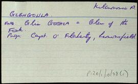
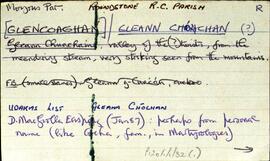
              Set of index cards describing the local features of the townland of Glencoaghan [Gleann Chóchan]. Features described include a lime kiln, Mám na bhFonsaí (recorded as Mám na Uinsí or rim in some places), Lotaí, Tinteánaí, Trinsí, Binn Dubh (Bencollaghduff on the OS map), The Planted Island, a Children's Burial Ground (a photo of which is included in 'Croí Chonamara'), Bengower, An Sindile (an arable area rich in quartz, and with a lime kiln), Mám Dearg (between Binn Dubh and Binn Bhán), Aill an Torainn, the mines (possibly sulphur), Binn Gabhair, Cnoc Trasna, Loch Cúl an Drama, Log an tSabha, Mám na Gaoithe, Mám an Lotaigh, and Fonsaí Ghaineamh. Local sources credited with providing information include local man Pat Joyce, Dela McAuley and Martin O'Malley, William O'Brien of Lotaí, Mrs Leonard of Ballinahinch Lodge, and John Hynes of Gleann Chóchan. (See also Teivebreen/Taobh Braoin for a brief description of Binn Briain, located between the two townlands).

              Robinson,Tim,Joyce,Pat,McAuley,Dela,O'Malley,Martin,O'Brien,William,Hynes,John
              Glencraff
              UGA P/P120/1/3/32/1 · Item
              Part of Personal

              Set of index cards describing some of the local features of the townland of Glencraff, [Gleann Creamha]. Included are descriptions of Aill an Ghabhair, Gabhlóg Struthán Mór, Clochán na Bean Sí, Sruthán Mór, Anacair, Children's Burial Ground, Lug na Coille, Eas Dubh, Doirín, Lug an Fhia, Ceannáin Bhán, Cloch an Domhnaigh, Búcán, Cnocán an Iolra, Aill an Iolra, The Glen River, Pulófra, Megalithic Tombs, the Holy Well (which is locally associated with a St. Craff), Cloichín, and Easca Riabhach. Michael O'Néill and Chris O'Néill are credited with providing the information.

              Robinson,Tim,O'Neill,Michael,Chris
              Glenbrickeen
              UGA P/P120/1/6/30/1 · Item
              Part of Personal

              Set of index cards giving a description of the townland of Glenbrickeen, [Gleann Bricín]. Included is a description of Fiodán Trasnaigh, the stream flowing from the north into Glenbrickeen Lough. T. Joyce is credited as being a local source of the information.

              Robinson,Tim,Joyce,T.
              Glen
              UGA P/P120/1/6/31/1 · Item
              Part of Personal

              Set of index cards giving a description of the townland of Glen, [An Gleann]. Included are descriptions of rock shelters (possibly Booley huts), Loch na h-uamain (the lake of the cave), Farawan Lake (the local pronunciation, Lough Nawarawaun on the OS maps), and Meall agus Caorán. Mike Gibbons, and Philomena and Tom Welsh of Cushatower are credited with providing some of the local information.

              Robinson,Tim,Gibbons,Mike,Welsh,Philomena,Tom
              Glebe
              UGA P/P120/1/10/79/1 · Item
              Part of Personal

              Index card relating to the townland of Glebe, [An Ghléib].

              Robinson,Tim
              Gleann Trasna
              UGA P/P120/1/7/17/1 · Item
              Part of Personal

              Set of index cards describing some of the local features of Gleann Trasna, [Glentrasna]. Included are descriptions of Tobar Mhiuceanach, Loichín na hÁithe, Croc Ghleann Transna, Clochar na Spíocán, Loichín na Calgaí, Loch Ghleann Trasna, Loch na Spiorthe, Cnocán an Bhodaigh, Brocach an tSionnaigh, An Geata, and Aill an Ghlais. Localman Seán Neide Ó'Conghaile, and Paddy Folen of Scríb are credited as being local sources of information.

              Robinson,Tim,Ó'Conghaile,Seán Neide,Folen,Paddy
              Gleann Mhac Muirinn
              UGA P/P120/1/10/9/1 · Item
              Part of Personal

              Set of index cards detailing some of the local features of the townland of Gleann Mhac Muirinn [Glenicmurrin]. Part of the Martin Estate. A brief note on Holly Island and Rook Island, and on Lough Cloonelola, Lough Derreenacummer, and Loughcloonadoon.

              Robinson,Tim,Folan,Tom,Ní Dhonncha,Maggie Pheigín
              Gleann Chraois
              UGA P/P120/1/1/30/1 · Item
              Part of Personal

              An index card describing the townland of Gleann Chraois [Glencrees]. Features descried on a card include a quaking bog, horneblende crystals have been found near Cashel Hill, and a couple of sheep shelters.

              Robinson,Tim
              UGA P/P120/1/2/22/1 · Item
              Part of Personal

              Set of index cards describing Gleann na Rod [Glenaruid]. Some speculation on the meaning of the placename derived from various sources. A note from Robert Simington's 'Books on Survey and Distribution' about the transfer of the lands of Glannarud from Ferdinando Follin to Richard Martin. A note on Loch Cruinn, or Glenaruidmore Lodge on the OS maps.

              Robinson,Tim