Click on the image to access the full item on the digital library
Identity area
Reference code
Title
Date(s)
Level of description
Extent and medium
22pp
Context area
Name of creator
Biographical history
Repository
Archival history
Immediate source of acquisition or transfer
Content and structure area
Scope and content
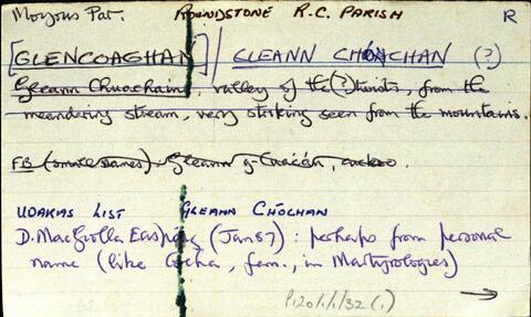
Set of index cards describing the local features of the townland of Glencoaghan [Gleann Chóchan]. Features described include a lime kiln, Mám na bhFonsaí (recorded as Mám na Uinsí or rim in some places), Lotaí, Tinteánaí, Trinsí, Binn Dubh (Bencollaghduff on the OS map), The Planted Island, a Children's Burial Ground (a photo of which is included in 'Croí Chonamara'), Bengower, An Sindile (an arable area rich in quartz, and with a lime kiln), Mám Dearg (between Binn Dubh and Binn Bhán), Aill an Torainn, the mines (possibly sulphur), Binn Gabhair, Cnoc Trasna, Loch Cúl an Drama, Log an tSabha, Mám na Gaoithe, Mám an Lotaigh, and Fonsaí Ghaineamh. Local sources credited with providing information include local man Pat Joyce, Dela McAuley and Martin O'Malley, William O'Brien of Lotaí, Mrs Leonard of Ballinahinch Lodge, and John Hynes of Gleann Chóchan. (See also Teivebreen/Taobh Braoin for a brief description of Binn Briain, located between the two townlands).
Appraisal, destruction and scheduling
Accruals
System of arrangement
Conditions of access and use area
Conditions governing access
Conditions governing reproduction
Language of material
English