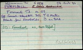
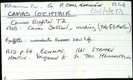
Set of index cards describing some of the local features of Camas Íochtair, [Camus Eighter]. Included are descriptions of An Seanséipéal, Loch an Iolra, Loch an Chriathraigh, An Baile Thiar, Cora Cláir, Céibh an tSagairt (a large stone pier 400 yards south of the bridge), Camas Craoibhe, Aill na bPáistí, Luifearnán, Cuan Chamais, Poll Chamais, Caorán an Iolra, Loch Chamais, Áth na gCorp, Bóthar an Cheap, Corr na Raithní, Cora Phatch Bhairtle, Caladh Domhain, Aill na gCaorach, Leacht na Sapeirs, Aill Mhór, Carraig an Bhaile, and Béal an Dá Linnín. A local person identified as Welby, Peter Flaherty of Camas, and Paddy Folan of Scríb are credited as being local sources of information.
Robinson,Tim,Flaherty,Peter,Folan,PaddyLoch an Chriathraigh
2 Archival description results for Loch an Chriathraigh
2 results directly related
Exclude narrower terms
UGA P/P120/1/7/5/1
·
Item
Part of Personal
UGA P/P120/1/7/15/1
·
Item
Part of Personal
Set of index cards describing some of the local features of Formaoil, [Formweel]. Included are descriptions of Abhainn Fhormaoil, Lough Carrickillawallia, Loch Doirín, the Zion Mór, Loch an Roisín (Lough Cloondola on the OS map), The Rack (a narrow place on the river between two lakes. The manager of the fishery had a sluice he would open to encourage salmon), Loch Fhormaoil, Holy Well, Formoyle Lodge, Loch an Chriathraigh, and Cnoc Fhormaoil. Mr. Walsh of Muireanach na Coille, Helen Spellman, and Matthew Costelloe of Formaoil are credited as being local sources of information.
Robinson,Tim,Spellman,Helen,Costelloe,Matthew