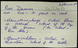
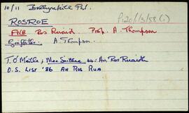
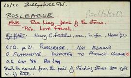
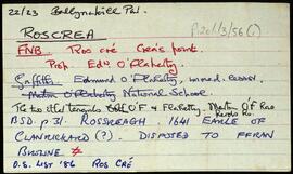
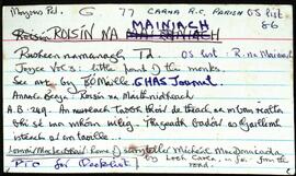
Ireland

Elements area

Taxonomy

Code

Scope note(s)

    Source note(s)

      Display note(s)

        Hierarchical terms

        Ireland

          Equivalent terms

          Ireland

            Associated terms

            Ireland

              667 Archival description results for Ireland

              667 results directly related Exclude narrower terms
              Dúleitir Thiar
              UGA P/P120/1/2/15/1 · Item
              Part of Personal

              Set of index cards describing some of the features of the townland of Dúleitir Thiar [Dooletter West], including Loch Throiscín, Loch Dhúleitir, Loch na dTulach, Loch an Áiléir, Tamhnach Ruaidí, Loch Dubh, Loch Dhuleitir Beag, Cloch an Mhíle, Tamhnach Loch an Áiléir, and Loch Sheana na bPóil. Seán Ó'Ceoinín credited as being the main source of information for this townland.

              Untitled
              Glinsce
              UGA P/P120/1/2/23/1 · Item
              Part of Personal

              Set of index cards describing some of the natural physical features of the townland of Glinsce [Glinsk]. Various sources are referenced giving insights into the origin of the placename, from Patrick Weston Joyce's 'The Origin and History of Irish Names of Places, Vol 3', which interprets it as the glen of the bramble bushes, to a local man who believes it derrives from 'gleann uisce'. Some notes are also provided on the modern day uses of buildings referenced in the OS maps, for instance the local school, Glinsk House, and Marble Studio. The physical features described are Loch an Roisín, Rusheen Point, Cnoc Glinsce, An Charraig Leith, Caladh Beag, An Caladh Mór, Corrán, a Children's Burial Ground, Loch Bhairtle, Barr an Linnín, Cnoc Bharr an Linnín, Abhainn Bharr an Linnín, Loch Cnocán na gCalapp, Caladh Thiobóid, Loch na Dubhaí (Lough Peastia on the OS maps, from the Irish word for worm, péist), Loichín Bharr an Chriathrach, Barr an Chlaí, Loch an Chaoráin, Céibh an Chaltha Mháire, Loch an Tamhnaigh, Tamhnachaí, Loch na Liathróide, Tulach na mBan, Loch an Mheill Mhóir, Tobar Mhuire, and Cuan na Beirtrí Buí. Information sourced from Bedford's map, Annála Beaga, and locally from Seán Ó'Ceoinín, Josie McDonncha, Frank Keaney and his grandmother, Josie Phádraig Cionnaigh, and Tomás Ó'Conghaile.

              Untitled
              Fínis
              UGA P/P120/1/2/19/1 · Item
              Part of Personal

              Set of index cards describing some of the features of the townland of Fínis [Finish Island]. Some information from the Field Name Books, and derived from local lore about there being a burial ground for children and strangers in the centre of the island. Included in the descriptions are Trá Theach na Scoile, Tóin an Oileáin, An Gearrán, Carraig Bháird, Mullán an Róin, Trá na Leaca, Na hAnlacain, Béal na Trá, An Trá Mhóir, Trá na Muice, Trá an Uisce, Trá Bhun an Chlaí, Trá Dhubháinín, An Mhuic Ghainimh, Carraig Sheáin Uí Fheinne, Carraig Chrochúif, Carraig Éamainn, An Mhuc Ghainimh (referred to as 'Feenish Spit' on an Admiralty Chart), An Leachta, Carraig an tSeoigigh (Joyce's rock), Cora Phádraic Con Rí, Trá Thulach Thirin, An Clo' Bhuaile, Trá Bheag, Céibh an Chalaidh Mhóir, Trá na bhFataí Biata, Bóthar na Scoláire, Trá na Mumhan (a possible reference to settlers from Co. Clare), Leacracha Mhuintir Churraidhin (named after three Cill Chiaráin men who drowned), Poll na Sean-toinne, and Tobar Cholm Cille (an anecdote from Coilín MacDonncha included here, in Irish). Some local people credited with provding information, these are named as Coilín MacDonncha, S Ó'Ceoinín, P de Búrca, and E. Ó'Néill.

              Untitled
              Gabhla
              UGA P/P120/1/2/21/1 · Item
              Part of Personal

              Set of index cards describing some of the features of the townland of Gabhla [Gowla]. Some historical information from Griffith's Valuation, and from the 1849 sale of the Martin Estate is included, which notes a salmon fishery was held by Daniel Bowden Smith on lease on Gowla River and lakes. Included in the descriptions are Abhainn Ghabhla (Owengowla), Loch an Duine (occasionally this is named Loch Marú an Duine locally, the site of where a man was killed for the half crown in his pocket), Loch na nOileán (Loughanillaun on the OS, known by the Fisheries as Gowla lake, and locally as Loch Barr na hAbhann), Loch an Aonoileáin, Barr na dTamhnach Gabhla, Loch Crocán na Gaoithe, Loch an Chlochair, Loch na mBreac Geal, Loch na Maidí, Cnoc Seana na Sith (some notes on the confusion behind its name), Coill an Gháigín, Sruthán na Teorann, Gabhla Bay/Cove, Loichiní Choill an Gháigín, Loch Tulaí Buí, Poll Sáile, Loch an Dín, Eas Mór, Gabhla Mór, Loch Fhada, Abhainn Ghabhla Beag, An Cnoc Breac, Loichín Salach, Loch na Tamhnái, Loch an Fhideáin, Loch Cúl an Dhrama, Loichín Caoch, and Gleann Aill an Tarra. Patrick King and Mike Coyne are two local sources credited with providing information.

              Untitled
              UGA P/P120/1/2/25/1 · Item
              Part of Personal

              Set of index cards describing some of the natural physical features of the townland of Inis Mhuscraí/Inis Múscraí [Inishmuskerry]. Some information on historical industry associated with this place, Annála Beaga notes it as a place of kelp making. Features described include Mullán an 'Majesty', Tóin na mBracaí, Caladh o Dheas, Carraig Fhada, Foirnis, Carraig na nDuibheán, Na Dolachtaí, Carraig an Loinsge, Barr an Ghoimh, An Raighleach, Biorán (Birane Rock on the OS maps), Caladh ó Thuaidh, Aill na hIomlachta, Carraig an Loinsge (Carrickalusk on the OS maps), and Carraig an Ghloinigh. P de Burca, Seán Ó'Ceoinín, and the information on Carraig an Ghloinigh credited to 'Cladaigh Chonamara', written in 1938 by Séamus Mac an Iomaire.

              Untitled
              Glionnán / Gleannán
              UGA P/P120/1/2/24/1 · Item
              Part of Personal

              Set of index cards describing some of the natural physical features of the townland of Glionnán/Gleannán [Glennaun]. Anecdotal information from the Annála Beaga, and reference to Ferdinando Follin [Feargananim Folan], the landowner in 1641, later disposed to Sir Thomas Meredith. By the time of the sale of the Martin Estate in 1849, the land was used by tenants for putting cattle out to pasture. Features described include Tamhnach na gCoileach, Cnocán an Bhodaigh, Loch Fhada Ghlionnáin [Glennaun Lodge on the OS maps], and Aill Mhór Ghlionnáin. Some of the information Tim Robinson found for Glennán was in a letter by Eoin Ó'Néill. Seán Ó'Ceoinín is also a local source of information.

              Untitled
              An Gabhlán Thoir
              UGA P/P120/1/2/20/1 · Item
              Part of Personal

              Set of index cards describing some of the features of the townland of An Gabhlán Thoir, [Gowlan East]. Included in the descriptions are The New Lake (Lough Ennahower on the OS maps), Bóthar an Mhása Mhóir, the ruin of a Hatchery, Loch an Tamhnaigh, Sruthair Mhór, Árd an Ghabhláin, Hazell's Lough, Loch Tan, and Loch na Brocaí. Professor Wilkins of UCG is credited with providing information about the hatchery, other local sources contributed to the information collected on this townland, but they are un-named.

              Untitled
              Dú Leitir Thoir
              UGA P/P120/1/2/17/1 · Item
              Part of Personal

              Set of index cards describing some of the features of the townland of Dú Leitir Thoir [Dooletter East]. Included in the descriptions are Cora na bPeelers (includes story about its name and the ghosts who haunt it), Cnoc Dhúleitir, Loch Fhada Glionnáin, Loch na Tamhnaí, Loch an Aonoileáin (mis-named Loughaunalyer on the OS maps), Loch na gCloch, Loch na bhFaoileán, and Loch an Dúigh. J Guairim and Seán Ó'Ceoinín credited with providing information.

              Untitled
              Dumhaigh Ithir
              UGA P/P120/1/2/18/1 · Item
              Part of Personal

              Set of index cards describing some of the features of the townland of Dumhaigh Ithir [Dooyeher]. Some notes describing the naming and history of Dumhaigh Ithir, and a note to say the storyteller Seán MacCon Ríog was born here. Included in the descriptions are An Duach Mhór (a sandy area by the beach, and the site of a holy well), An Aill Dhubh, Loch Bhun an Chluife, Céibh an Choradáin, Caladh an Bháid, Gob an Phointe, and An Trá Mhór. Local man Eoin Ó'Néill credited with providing some of the information.

              Untitled
              UGA P/P120/1/2/22/1 · Item
              Part of Personal

              Set of index cards describing Gleann na Rod [Glenaruid]. Some speculation on the meaning of the placename derived from various sources. A note from Robert Simington's 'Books on Survey and Distribution' about the transfer of the lands of Glannarud from Ferdinando Follin to Richard Martin. A note on Loch Cruinn, or Glenaruidmore Lodge on the OS maps.

              Untitled