Ireland

Elements area

Taxonomy

Code

Scope note(s)

    Source note(s)

      Display note(s)

        Hierarchical terms

        Ireland

          Equivalent terms

          Ireland

            Associated terms

            Ireland

              667 Archival description results for Ireland

              667 results directly related Exclude narrower terms
              Aircín Mór
              UGA P/P120/1/1/3/1 · Item
              Part of Personal

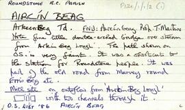
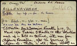
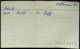
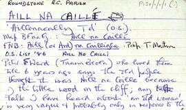
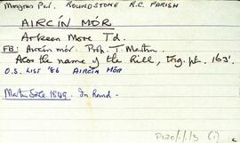
              Set of index cards describing geographical features, the naming, and the lore of Aircín Mór [Arkeen More]. Descriptions of Loch Reddington, Loch Thaidhg, Loch Fhamhnóg Fhraoi (referred to elsewhere as Lough Tromnóg Ree, and located between Aircín Mór and Doire Mhic Reoin), Dooloughaunarkeen, and Loch Oileáin Mhór. Paddy Linnane and his brother Francis of Roundstone are credited with providing information, and their speculation about 'an old woman or cailleach' who lived on an island on Loch Reddington is recorded here. [Possible reference to Aill na Caillí].

              Robinson,Tim,Linnane,Paddy,Francis
              Aircín Beag
              UGA P/P120/1/1/2/1 · Item
              Part of Personal

              Set of index cards describing the name, residents, geographical features, and monuments in Aircín Beag [Arkeen Beg]. Descriptions of a double-arched bridge, the Mill Site, Loch Féilim (located between Aircín Beag and Doire Mhic Reoin), and the Aircíní included. Joe Nee of Tuaim Beola [Toombeola] credited with providing information.

              Robinson,Tim,Nee,Joe
              Aillenaveagh
              UGA P/P120/1/6/1/1 · Item
              Part of Personal

              Two index cards describing some of the local features of the townland of Aillenaveagh, [Aill na bhFiach]. A note from T Ó'Máille's 'An t-Iomaire Ruadh' about a meeting of the Volunteers here in 1920 after the burning of Clifden. Also included is a brief description of Log an Aifrinn from the Field Name Books.

              Robinson,Tim
              Aille
              UGA P/P120/1/11/24/1 · Item
              Part of Personal

              Set of index cards describing some of the local features of the townland of Aille, [Na hAille]. Notes are included on Gannaidh na ceanta, Dooletter, Tievegarriff, Ballyfanagh, Bun na sruthbhán, Clochar Canóig, Sruthán Buidhe, Eighternaaylle and Callowmore.

              Robinson,Tim
              Aill na Caillí
              UGA P/P120/1/1/1/1 · Item
              Part of Personal

              Set of index cards describing the name, residents, geographical features, and monuments in Aill na Caillí [Aillenacally/Aillnacally]. Includes an account from a former resident that suggests the original name may have been Aill na Coille 'because of the little wood on the cliff'. Loch Mártain, the Holy Well, Cnocnán Mór, Cora Mór, The Pounds, Aill Mór, and The Green Island are all described. Peter Ward of Tuaim Beola [Toombeola] credited with providing some information.

              Robinson,Tim,Ward,Peter
              Aill Bhreac
              UGA P/P120/1/5/1/1 · Item
              Part of Personal

              Set of index cards describing some of the local features of the townland of (An) Aill Bhreac, [Aillebrack]. Included among the set of cards are descriptions of Carraig an Lios (more familiar to locals as Carraig Áilis, or Ailice's rock, used as a place to bury children until 1803), Split Rock, Cnocán Breac (Guaire na bpáistide in the Field Name Book), Holy Well and Mass Rock, Cé Bhun Abhann, Maidhm Cromaill (Cromwell Shoal), Straw Beach Island, Loch Caffrey, Bóithrín Beag, Lochán Buí, Oileán Ura (Illaunurra), Loch an Doirín, Sand Lake, Dóilainn Harbour, Cnocán na hAille Brice, Horse Island, the Well of the Seven Daughters (sometimes known locally as the Well of the Seven Sisters), Midden, Creig, Carraig Cumair, Carraig an Ghamhna (Calf Island), Buachaill (Boughillcarrickcark/Bóchaill), Carraig an Locháin, Carrach an tSeoighe, Corrach an tSrutha, Corrán, Tóin an Rosa, Carraig an Fhuaruisce, the Coastguard Station, Murlach, For Buaile, the Children's Burial Ground, Carraig an Fhioruisce, Corrán Beag, and Corrán Mór. Seán King of Ballyconneely, Martin O'Malley of Roundstone, and local man Jim O'Malley are credited with providing some of the information.

              Robinson,Tim,O'Malley,Martin,King,Seán,Jim
              Addergoole
              UGA P/P120/1/3/2/1 · Item
              Part of Personal

              Set of index cards describing some of the local features of the townland of Addergoole, [Eadargúil]. Included are descriptions of the National Park lands, in which he traces the ownership of the land since after the Famine, during which time it was part of the Martin Estate, the property of the Barrow and Calcutta Jute Company, James P Joyce, and currently the property of the OPW. Kylemore Farmhouse and yard are also described, with some detail on Addergoole Farm in the 19th and 20th centuries (a model farm, in which bogland was reclaimed, and the site of a turbine which powered a local sawmill). Tullygwee Bridge (Tulaig Guide bridge over the Dawros River), Glencorbet, Meacanach (Muckanaght) are also described.

              Robinson,Tim