Ireland

Elements area

Taxonomy

Code

Scope note(s)

    Source note(s)

      Display note(s)

        Hierarchical terms

        Ireland

          Equivalent terms

          Ireland

            Associated terms

            Ireland

              667 Archival description results for Ireland

              667 results directly related Exclude narrower terms
              Streamstown or Barratrough
              UGA P/P120/1/6/54/1 · Item
              Part of Personal

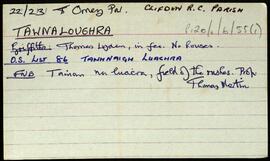
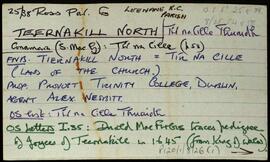
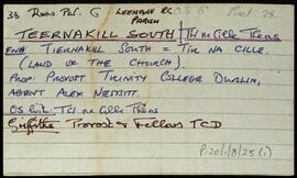
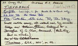
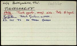
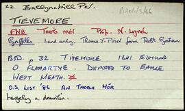
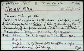
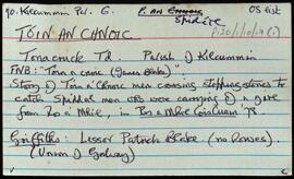
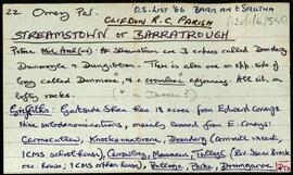
              Set of index cards giving a brief description of the townland of Streamstown or Barratrough, [Barr an tSrutha]. Included are descriptions of what Robinson describes as a "rather complicated megalith". He refers to a corresponding sketch in one of his notebooks.. Further descriptions are given of Toabh an Locha, the slab (a site for turf cutting), an early Christian rath, Loch Tanaí, Teampall Atha Deirg (the church of Athdearg), a note on Streamstown where there is a house known as Coney's, a waterfall, and a rookery. Also included are a brief description of Streamstown Bay, and Cloghalegaun. Mike Gibbons and Pappy Mannion are credited as being local sources of information.

              Robinson,Tim
              Tawnaloughra / Townaloughra
              UGA P/P120/1/6/55/1 · Item
              Part of Personal

              Index card giving a brief description of the townland of Tawnaloughra/Townaloughra, [Tamhnaigh Luachra].

              Robinson,Tim
              Teernakill North
              UGA P/P120/1/8/26/1 · Item
              Part of Personal

              A set of index cards outlining briefly some of the local features of the townland of Teernakill North, [Tír na Cille Thuaidh]. Included are descriptions of the Mass Rock, Léana (a local village), Tobar Feichín (site of a holy well and a burial ground), Scoil Bhríde, Cnoc Beag, and Lugán. The local principal Mrs Tierney, local man Mr. MacAodha, and Willy Crawford are credited as being local sources of information.

              Robinson,Tim,Crawford,Willy
              Teernakill South
              UGA P/P120/1/8/25/1 · Item
              Part of Personal

              A set of index cards outlining briefly some of the local features of the townland of Teernakill South, [Tír na Cille Theas]. Included are descriptions of Binn Ramhar, Droichead an Easa (Shaughnessy's Bridge on the OS map), the Copper mines, a holy well, lake, and bridge, Tulachaí, Mám Aodha, Tír na Cille River, Aill na Lady, Corcóg, Log an tSamh, Bucán, Loigín Dóite, Meall, Binn Chaoinghí, Caobóg, Cúl an Easa, Na Cruic Breaca, and Binn Mhór. Will Crawford from Mám, Nora Keane, Mary Keane, Willy Sutcliffe, and a person identified as Lydon from Bun a Bhucáin are credited as being local sources of information.

              Robinson,Tim,Crawford,Will,Keane,Nora,Mary,Sutcliffe,Willy
              Tievebaun
              UGA P/P120/1/6/58/1 · Item
              Part of Personal

              Set of index cards giving a brief description of Tievebaun, [An Taobh Bán]. Included are descriptions of Binn Bhreac, and Magairle (a peak). John Mannion of Barnanoraun, and Teresa Mannion are credited as providing some of the local information.

              Robinson,Tim
              Tievegarriff
              UGA P/P120/1/3/65/1 · Item
              Part of Personal

              Index card relating to the townland of Tievegarriff, [An Taobh Garbh]. Brief information derived from Griffith's Valuation, and the relevant Field Name Book.

              Robinson,Tim
              Tievemore
              UGA P/P120/1/3/66/1 · Item
              Part of Personal

              Index card relating to the townland of Tievemore, [An Taobh Mór]. A note about a drumlin in the area, and some information derived from Griffith's Valuation.

              Robinson,Tim
              Tír an Fhia
              UGA P/P120/1/11/22/1 · Item
              Part of Personal

              Set of index cards describing some of the local features of the townland of Tír an Fhia, [Teeranea]. Included are descriptions of Oilither Chuch (possibly early medieval, and much restored. The church is shown in the Down's Survey, and on Larkin's map of the county). Also described are An Caisleán, Céibh Ghlais na nUan, Tobarín 'P', Cuinneógan Fhir Mhóir, An Cloch Mhóir, Loch Tan, Tobairín Naoimh, An Trá Bhán, Cladach Bhun an Charnáin, Bun an Charnáin, An Seanséipéal, the Holy Wells at Trá an Doirín, Céibh an Dóirín, An Dóirín Darach, Na Leacracha Móra, Trá Mhóir Tír na Fhia, Carraig na mBan, Barr na Trá Báine, An tAircín, Teach an Éisc, Carraig an Tornóg Aoil, Leach Chuimhneacháin Pheait na Maistreasa, Loch na Trá Báine, An Charraig Mhór, Árd na gCapaill, An Aill Aighneach, Cnoc na bhFiann, An Léana, An Chois Chaoil, Cora Dhonnchadha, An Clochar Bán, Lathnach Iomair, Gleann Aingle, Clochar Dóite, Cora an tSeoighe, Gleann Pháraic Dhonnchadha, An Chaladh Bheag, Poll na Ronnach, Stupóg Neansaí, An Dúiche, Carraig Mhaoile, Ard an tSléibhe, Poll Mhatios, Crompán Leathan, An Locháinín, Ard Loch an Ghaineamh, Leac Mhór Phatch Liam, Mulán Crón, An tAircín Deocair, An Mhuiceoil, An Poll Domhain, Loch na bhFeadán, An Criathrach, Loch Pheadair, Cora na Teorann, An Trá Gharbh, Cuan Thír an Fhia, Gob na Trá Báine, Mount St. Anne, Clochar na Toirbhirte, the local industrial estate, Tir an Fhia, Aill na Móna, Caladh na Spéice, Bóthar na Trá Móire, Crompán na Gleanna Móire, An Pháirc, and Leaca Tí Mhóir. P Ó'Cualáin and The MacDonncha are credited as being local sources of information.

              Robinson,Tim,Ó'Cualáin,P.
              Tóin an Chnoic
              UGA P/P120/1/10/17/1 · Item
              Part of Personal

              A large series of index cards describing some of the local features of the townland of Tóin an Chnoic, [Tonacrick]. Included are descriptions of An Seanbhaile, Cara Mhór, Gob Thóin an Chnoic, and Cuan Fhortail.

              Robinson,Tim
              Tonadooravaun
              UGA P/P120/1/3/68/1 · Item
              Part of Personal

              Set of index cards describing some of the local features of the townland of Tonadooravaun, [Tóin an Dúrabháin]. Included are descriptions of a Court Tomb (known locally as Leaba Dhiarmaid), Fó Dhiarmaid, Bullán Buí, Carraig na mBroigheall, Fó Droichid, Fuaigh Philib, Carraig Thaidhg Óig, Poll Gorm, Fó Choilm, Carraig Sheáin Uí Ní, Poll Buí, Leac ó Dara, Leac na Mangach, Fó na gClár, Carraig Allta, Fó na gCaorach, Bócáns, Maolán an Duilisc, Fó Dá Dhorais, Aill Mhic, Fuaigh na mBan, Fó Liamháin, Fó Bhulláin, Carraigí Sheáin Mhóir, Fó Bheag, and Carraig an Bhradáin. Mike Gibbons, Paddy Hearne, and Paddy Fitzpatrick are credited with providing some of the local information.

              Robinson,Tim,Gibbons,Mike,Hearne,Paddy,Fitzpatrick