Ireland
667 Archival description results for Ireland
667 results directly related
Exclude narrower terms

UGA P/P120/1/6/16/1
·
Item
Part of Personal
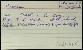
Set of index cards describing some of the local features of the townland of Coorhoor/Courhoor, [An Corrbhóthar]. Included are a description of a Crannóg, a pre-bog wall, and Scailp Val, named after Valentine Jordan, a notorious character who fled here from Mayo in 1798. Mike Gibbon is credited as being a local source of information.
Robinson,Tim,Gibbons,Mike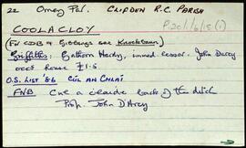
UGA P/P120/1/6/15/1
·
Item
Part of Personal
Set of index cards describing some of the local features of the townland of Coolacloy, [Cúl an Chlaí]. Included are descriptions of Hog Island, the Coast Guard Station, Cuan an Bhaidhe, Oileán na nÚan, Cúl an Chruit, Tiompán, Maol an Bhreallaigh, The Boat Rock, Cuan na Loinge, Carraig an Tí, Tóin na Leachtaí, and Béal an tSrutha. Local man Patrick Joyce is credited with providing some of the local information.
Robinson,Tim,Joyce,Patrick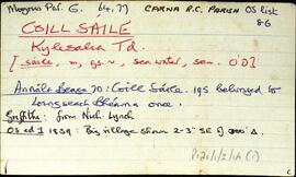
UGA P/P120/1/2/14/1
·
Item
Part of Personal
Set of index cards describing some of the features of the townland of Coill Sáile [Kylesalia]. Features described include Carraig an Chomair, Crompán Choille Sáile, Sruthán na mBrácaí, An Chara Dhubh, Flannery Bridge, Cloch na dTaibhsí, An Garraí Graf, An Meall, Crompán Thaidhg na Buile, Na Caisleáin, Cora Ró Dúgáin, Meall Gorm, Ros Cam, Crompán Lannach, Aill Uaithne, An Criathrach Mór, Loch na Teorann, Cloch Ádhbhach, Ros Dubhgáin, and Tobar Cholm Cille. Pat Sullivan, Professor Seán de Courcy, Seán Dundass, Pádraic MacDonncha, and Máire Canavan all credited with providing information.
Robinson,Tim,Sullivan,Pat,Courcy,Seán de,Dundass,Seán,MacDonncha,Pádraic,Canavan,Máire
UGA P/P120/1/3/14/1
·
Item
Part of Personal
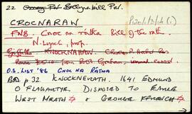
Set of index cards describing some of the local features of the townland of Cnocnaraw [Cnoc na Rátha]. Descriptions are given of Crocnaraw, formerly known as Rockfield House, which was an orphanage run by Protestant clergymen known as The Forty Boys. Two white quartz boulders known as the Standing Stones, an enclosure, and Maam Green are also described. Mike Gibbons is credited as being a source of some of the information.
Robinson,Tim,Gibbons,Mike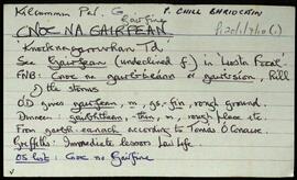
UGA P/P120/1/7/10/1
·
Item
Part of Personal
Set of index cards describing some of the local features of Cnoc na Gairfine [Knocknagarrivhan]. Included are descriptions of Loch na Gairfine, Loch na bhFreangach, Loch an Damba, and Loch na hAille. Peter Flaherty, and Mr. Walsh of Muic na Coille are credited with providing some of the local information.
Robinson,Tim,Flaherty,Peter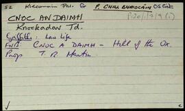
UGA P/P120/1/7/9/1
·
Item
Part of Personal
Set of index cards describing some of the local features of Cnoc an Daimh, [Knockadav]. Robinson offers a translation of Hill of the Ox, derived from the Ordnance Survey Field Name Books. Included are descriptions of Loch na hEasléime, Tmnach Lug na gCléireach, the Old Road to Derrough North, Tobar Beannaithe, Cara Throiscín, An Leacht/Leachta Labhráis, An Tall Darach, a note on the Salmon Hatchery (one of the earliest in Ireland), Loch Bhallaí Mhongáin, Loichín Nora Ní Niaidh, Seana Mhac Conraoí, Loichín Bharr an Éadain, Loch an Fhraoigh, Aill an Chliabhraigh, Barr na dTamhnachaí Bána, Criogán na Seithe, An Draem Bhoiste, Binn Ard Loch an Daimh, Log na gCleireach, and Garraí Ruaidí. Paddy Folan of Scríb, and Paddy Joyce of Úraid are credited as being local sources of information.
Robinson,Tim,Folan,Paddy,Joyce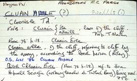
UGA P/P120/1/1/15/1
·
Item
Part of Personal
Set of index cards describing the physical features of Cluain Aidhle [Cloonisle]. Descriptions given are of Gort Triomach, Cnocán na Ceártan, Garaí Mhary, Graves, Loch Shéamuisín Niaidh, The Buacáns, the Giant's Grave, the Green Gardens, Cnoc na Seitle, Lathach na Chaoráin, and Cnocán na gCorpr. Sources of information credited are a local person named Riley, Annie Conneely, and P. and A. Conneely.
Robinson,Tim,Conneely,Annie,Peter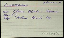
UGA P/P120/1/10/43/1
·
Item
Part of Personal
An index card relating to the townland of Clooshgereen, [Cluais Chéirín].
Robinson,Tim