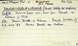
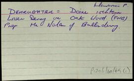
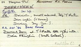
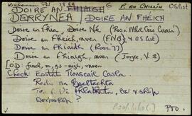
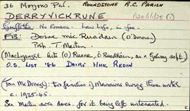
Set of index cards describing some of the physical features of Derryvickrune [Doire Mhic Reoin]. Descriptions are included of Lough Illaunwaun (Loc Oileán Amháin), Knocknafarderg Lough, a private forest in development, Lough Aleen, and Lough Garrybawn.
Robinson,TimIreland
667 Archival description results for Ireland
Set of index cards describing some of the physical features of Derryvealawauma [Doire Bhéal an Mháma]. Included in the descriptions are Cnoc Doire Bhéal an Mháma, Port an Dúín, Log Mhám Té, the Children's Burial Ground, Máméan, and Bun an Chnoic. A note on Bun na gCnoc and its status as a Gaeltacht during the Recess school boycott. Local Tamhnach Mór and Leitheanach people are credited with providing some of the information.
Robinson,TimIndex card relating to the townland of Derryughter/Derryeighter, [Doire íochtair].
Robinson,TimSet of index cards detailing some of the local features of the townland of Derrynea, [Doire an Fhéich]. Secondary sources consulted include Griffith's Valuation, Petty's map, Simington, and the Martin Estate Sale Map. Brief descriptions are given of the Costello Fishing Club, Teach na Cúirte, Lower Costello Fishery, Costello Lodge (which was burnt in the Civil War, and later rebuilt), Costelloe and Fermoyle Fisheries Co., Abhainn Chasla, Cuan Chasla, Cottage Pool, the lead mine, Tobar Naomh Phádraic, Loch an Mhianaigh, Loch Uí Chadhain, Loch Bharr an tSrutháin, Casla, the Children's Burial Ground, and Aill na Graí. Robinson credits Professor Wilkins' book as a source of information.
Robinson,TimSet of index cards describing the Stage House, and Log na Binne, a valley, in Doire na bhFlann [Derrynayglaun]. Local sources credited with providing information are Willie O'Malley and Pat Joyce of Gleann Clóchán.
Robinson,Tim,O'Malley,Willie,Joyce,PatIndex card giving a list of references for the townland of Derrynacleigh, [Doire na Cloiche], namely the Congested Districts Board, the OS Field Name Books, Griffith's Valuation, and some information on pronunciation derived by Tim Robinson from speaking with local people.
Robinson,Tim,Ireland. Congested Districts Board for IrelandSet of index cards describing some of the local features of the townland of Derrylea, [Doire Liath]. Included are descriptions of the Derrylea Mines, the Island Lough, Loch Fada, Joyce's Imleach, Derrylea Hill, and Loch an Arbhair are included in the descriptions. John Joyce of Emlaghmore, and Ritchie Savagh of Gowlan West are credited with providing the local information.
Robinson,Tim,Joyce,John,Savagh,RitchieIndex card describing some of the local features of the townland of Derrylahan, [Doire Leathan]. Included are some information from Griffith's Valuation, and some refeences to other sources.
Robinson,TimSet of index cards describing some of the local features of the townland of Derryinver, [Doire Inbhir]. Included are descriptons of Fuaigh na gCaorach (Toirannageeragh on the OS), The Tulach, the Cist, Ardach, Crocán Stiofáin, Carraig Dhubh, Finn MacCumhail's Fingers (six standing stones), Doon/Doongill (site of a small ring fort), and Cluain Lárach. Local woman Mrs McDonagh, Michael Gannon, Mike Gibbons, and Patrick Nee are credited with providing information.
Robinson,Tim,Gannon,Michael,Gibbons,Mike,Nee,Patrick