Ireland

Elements area

Taxonomy

Code

Scope note(s)

    Source note(s)

      Display note(s)

        Hierarchical terms

        Ireland

          Equivalent terms

          Ireland

            Associated terms

            Ireland

              667 Archival description results for Ireland

              667 results directly related Exclude narrower terms
              Garroman
              UGA P/P120/1/1/31/1 · Item
              Part of Personal

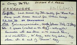
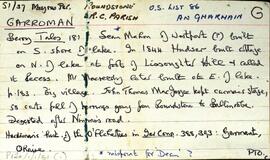
              Set of index cards describing the local features of the townland of Garroman [An Gharmain]. The first card relays accounts from different histories of Galway about the residents of Garroman from the mid-nineteenth century. An account of a monastery in Garroman exists. Local features described include Glendollagh House, of which hardly a trace exists in the present day. A detailed history of its ownership is given on these cards. Gleann dá Loch, Loch an Aifrinn, Loch na mBreac Mór, Loch an Ghiolcaigh, Fairy Hill, Loch na Sáinne, Glendollagh Fishery, Lady Dudley's Nurse's Cottage, Imleach Bharr an tSrutháin, Imleach Láir, Imleach na Seamar, Garroman Lodge, the police barracks, lochán na meacan, loch uí mhainnín, loch an imligh eise, and Garroman lake are included in the descriptions. Local sources of information are local man Tom Joyce, Annie Joyce of Leitir Seanadh, Kevin Joyce, Martin O'Malley of Ballinafad, and Joe Mannion of Garroman.

              Robinson,Tim
              Garraunbaun
              UGA P/P120/1/3/30/1 · Item
              Part of Personal

              Set of index cards describing some of the local features of the townland of Garraunbaun, [An Gearrán Bán]. A story is relayed about how the townland got its name, a white gelding. Features described include Ballinakill Chapel, Garraunbaun Doon, McMurray's carpets, a Standing Stone (possibly the rock called Gearrán Bán), the Nursery, a court tomb, and Garraunbaun House. Mr Lydon of Tooreen, Mike Gibbons, and the Galway Archaeological Survey are credited as being sources of local information.

              Robinson,Tim,Gibbons,Mike,Ireland. National Monuments and Historic Properties Service
              Gannoughs
              UGA P/P120/1/6/29/1 · Item
              Part of Personal

              Set of index cards giving a description of the townland of Gannoughs, [Na Gainmheacha]. Included are a note about a possible boulder dolmen (a debate surrounds it), Clochar (a shingle beach), Barr an Roiín, and Carraig chullú (Carrickculloo on the OS map). Robinson notes that he has spoken to Mike Gibbons and Seán Ó'Núallán about the possible boulder dolmen.

              Robinson,Tim,Gibbons,Mike,Ó'Núallán,Seán
              Gairfean
              UGA P/P120/1/7/16/1 · Item
              Part of Personal

              Set of index cards describing some of the local features of Gairfean, [Garrivinnagh]. Included are summary descriptions of Tóin an Droma, Céibh Chaladh na Gairfean, Straidhp an Tae, Caladh na Leice, An Roisín, and Garafin House where three generations of Connerys lived.

              Robinson,Tim
              Gabhlán Thiar
              UGA P/P120/1/4/5/1 · Item
              Part of Personal

              Set of index cards describing some of the local features of the townland of An Gabhlán Thiar, [Gowlan West]. A brief local history from 1798 is given, mentioning Fr. Myles Prendergast who joined the French in 1798, and his relationship with Richard Martin (Humanity Dick). Brief descriptions are given of Gowlan Lough and Gowlan Hill. Liam Ward, a fishery officer from Clifden, and Ritchie Savage of Gowlan West are credited with providing the information.

              Robinson,Tim,Ward,Liam,Savage,Ritchie
              Gabhla
              UGA P/P120/1/2/21/1 · Item
              Part of Personal

              Set of index cards describing some of the features of the townland of Gabhla [Gowla]. Some historical information from Griffith's Valuation, and from the 1849 sale of the Martin Estate is included, which notes a salmon fishery was held by Daniel Bowden Smith on lease on Gowla River and lakes. Included in the descriptions are Abhainn Ghabhla (Owengowla), Loch an Duine (occasionally this is named Loch Marú an Duine locally, the site of where a man was killed for the half crown in his pocket), Loch na nOileán (Loughanillaun on the OS, known by the Fisheries as Gowla lake, and locally as Loch Barr na hAbhann), Loch an Aonoileáin, Barr na dTamhnach Gabhla, Loch Crocán na Gaoithe, Loch an Chlochair, Loch na mBreac Geal, Loch na Maidí, Cnoc Seana na Sith (some notes on the confusion behind its name), Coill an Gháigín, Sruthán na Teorann, Gabhla Bay/Cove, Loichiní Choill an Gháigín, Loch Tulaí Buí, Poll Sáile, Loch an Dín, Eas Mór, Gabhla Mór, Loch Fhada, Abhainn Ghabhla Beag, An Cnoc Breac, Loichín Salach, Loch na Tamhnái, Loch an Fhideáin, Loch Cúl an Dhrama, Loichín Caoch, and Gleann Aill an Tarra. Patrick King and Mike Coyne are two local sources credited with providing information.

              Robinson,Tim,King,Patrick,Coyne,Mike
              Friar Island
              UGA P/P120/1/6/27/1 · Item
              Part of Personal

              Set of index cards giving a description of the townland of Friar Island, [Oileán na mBráthar]. Included are descriptions of Maol an tSrutha, and An Meall Thuaidh (pronouced 'Naltors' by local fishermen, possibly referring to both the northern islets). Robinson notes that fishermen on the High Island provided him with some of the local information recorded here.

              Robinson,Tim
              Fountainhill or Knockavilra
              UGA P/P120/1/6/28/1 · Item
              Part of Personal

              Set of index cards giving a description of the townland of Fountainhill or Knockavilra, [Cnoc an Bhiolra]. Robinson notes that Cnoc an Bhiolra can be translated as watergrass hill, or hill of the watercress. Included are descriptions of an Infant's Burial Ground, and Leaba Feichín, said to be where St. Feichín stopped before crossing to Omey.

              Robinson,Tim
              Fough East
              UGA P/P120/1/10/80/1 · Item
              Part of Personal

              Index card relating to the townland of Foagh, [An Fhuathach Thoir]. Corrib Dale and Tobar na bhFaithe are described briefly as being features of this townland.

              Robinson,Tim
              Formaoil
              UGA P/P120/1/7/15/1 · Item
              Part of Personal

              Set of index cards describing some of the local features of Formaoil, [Formweel]. Included are descriptions of Abhainn Fhormaoil, Lough Carrickillawallia, Loch Doirín, the Zion Mór, Loch an Roisín (Lough Cloondola on the OS map), The Rack (a narrow place on the river between two lakes. The manager of the fishery had a sluice he would open to encourage salmon), Loch Fhormaoil, Holy Well, Formoyle Lodge, Loch an Chriathraigh, and Cnoc Fhormaoil. Mr. Walsh of Muireanach na Coille, Helen Spellman, and Matthew Costelloe of Formaoil are credited as being local sources of information.

              Robinson,Tim,Spellman,Helen,Costelloe,Matthew