Ireland

Elements area

Taxonomy

Code

Scope note(s)

    Source note(s)

      Display note(s)

        Hierarchical terms

        Ireland

          Equivalent terms

          Ireland

            Associated terms

            Ireland

              667 Archival description results for Ireland

              667 results directly related Exclude narrower terms
              Inishturk
              UGA P/P120/1/6/35/1 · Item
              Part of Personal

              Set of index cards giving a description of the townland of Inishturk, [Inis Toirc]. Included are descriptions of Black Stick (a hill), Cara Chnoic, Baile Thoir, Baile Thios, Cuainín, Reilg, Caibidie, An tOileán Íseal, Glasoileán, Caladh Mór, Cnoc na Móna, Maoilín, Fuach Mhór, Carraig Mhuiris, and Tóin Rua. Mr. Hannon or Inishturk, and Mr. McDonagh of Eyrephort are credited with provoding some of the local information.

              Robinson,Tim
              Inishbofin
              UGA P/P120/1/12/2/1 · Item
              Part of Personal

              Series of notes about the local features of Inishbofin, [Inis Bó Finne]. A note on the the ownership of Inishbofin, from the Earl of Clanrickard, to the Brownes of Westport, to the Englishman Cyril Allies. A note on how Inishbofin fared during the Cromwellian invasion. Extracts from various sources including the 1st Report of the Fisheries Commission, Griffith's Valuation, and census returns. Kevin Whelan of UCD is credited as being a local source of information.

              Robinson,Tim,Whelan,Kevin
              Inis Ní
              UGA P/P120/1/1/37/1 · Item
              Part of Personal

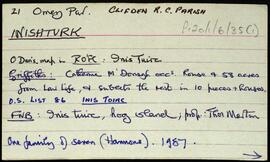
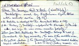
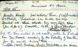
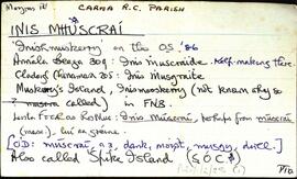
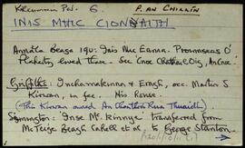
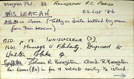
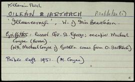
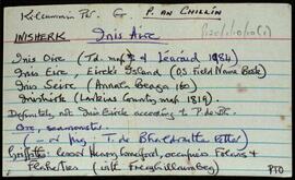
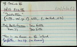
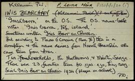
              Set of index cards describing the physical features of Inis Ní [Inishnee]. Located in Moyrus Civil Paris, and the Roman Catholic Parish of Roundstone. Robinson explains that Inis Ní is divided into three islands by very high tides. From North to South, these are Craobh, Cill, and An Ceann Ramhar. Data from the 1820, 1841, and 1851 census returns are included, Congested Districts Board data, some history of ownership dating back to the 16th century, and some information from the 1st Report of the Fishery Commissioners in 1836. Physical features which are described are: Tobar Cholm Cille [on the OS map, St Brendan's Monument is marked in the same place], Árd na gCapall, Caladh na bPortán, Caladh Flathartaigh, An Sruthar, Cloch Mhór Róisín, Poll Pháidí, Caladh Keane, Tuairín, Cora Mhór, Scaith Dhubh, Caorán, Glasoileán, Gleann na gCoileach, Carraig an Bhranda, Oileán an Chlaí, Loch Bheag, Gleann na gCat, Cnocán Mhairgín, An Storraicín [An Stoiricín], Aille an Gharraí Rua, Aille na Caillí, Cara Beag(a), Doilín Freangach, Caladh Cam, Cuan Leice, Poll Tobac, St. Mathias's Chapel, Na Bruachaí [Mud Hole], Maoilín Dóite, Cáblachaí, Caladh na Loinge, St. Brendan's Well, Inis Ní Lighthouse, Gleann na gCapall, Troscaí, Cnocán Árd Dhaibhéis, Oileán an Choirce, Aill na nÉan, Dóilín Mhór, Bóthrín Gaskin, An Chloch Bhiorrach, Croabh [Creevecarton], An Ceann Ramhar, Cill, Aill Dingle, An Duirling Bhán, Crompán Mór, Oileán na gCapall, Caladh Bháid Mhóir, Gleann Dúlamáin, Cnocán an Tuairín, An Comhartha, Cnocán Tine Cnáimh, Giúróg, Mhaidin an tSagairt, Cora Mháire Ní Iarla, Doire Fhatharta, Donegal, Carraig an Fox (connected with the story of the fox and the limpet - see also Fox Island, near Cashel), Cnocán an Fhatharta, Coirnéal Sáraithe, Cooneen na Roan, Cuainín, the Inis Ní Bridge, The Wire, Fort Island, Inis Ní National School, Muing na Fola, Daoláin, Tobar an Rí, and The Danes Fort. Many local sources are credited with providing information and stories. Those credited are Pádraig Nee, Festy Nee, Rose Green, Michael King, Mr Faherty, Martin Keene, Michael Keane, Conor Hamill, Paddy Folan, and Nimmo's map of 1823.

              Robinson,Tim,Nee,Pádraig,Festy,Green,Rose,King,Michael,Keene,Martin,Keane,Hamill,Conor,Folan,Paddy,Great Britain. Commission Appointed to Take the Cenus of Ireland,1841,Ireland. Congested Districts Board,Great Britain. Royal Commission of Inquiry into the State of Irish Fisheries,1836
              UGA P/P120/1/2/25/1 · Item
              Part of Personal

              Set of index cards describing some of the natural physical features of the townland of Inis Mhuscraí/Inis Múscraí [Inishmuskerry]. Some information on historical industry associated with this place, Annála Beaga notes it as a place of kelp making. Features described include Mullán an 'Majesty', Tóin na mBracaí, Caladh o Dheas, Carraig Fhada, Foirnis, Carraig na nDuibheán, Na Dolachtaí, Carraig an Loinsge, Barr an Ghoimh, An Raighleach, Biorán (Birane Rock on the OS maps), Caladh ó Thuaidh, Aill na hIomlachta, Carraig an Loinsge (Carrickalusk on the OS maps), and Carraig an Ghloinigh. P de Burca, Seán Ó'Ceoinín, and the information on Carraig an Ghloinigh credited to 'Cladaigh Chonamara', written in 1938 by Séamus Mac an Iomaire.

              Robinson,Tim,Burca,P. de,Ó'Ceoinín,Seán
              Inis Mhic Cionaith
              UGA P/P120/1/10/11/1 · Item
              Part of Personal

              Series of index cards describing some of the local features of the townland of Inis Mhic Cionaith, [Inchamakinna]. Robinson notes Martin S Kirwan was the occupier in fee at the time of Griffith's Valuation, and some notes on the occupiers/owners in the time since then. The last families left the island in 1973. Some brief notes on Cloch á Bheádáin, Mullán an breachta, An Caladh Mór, Bealach an tSnaimh, and An tOileán Iarthach. Robinson credits Tiachóg, a local periodical from around 1993 as being a useful source of some of the information.

              Robinson,Tim
              Inis Leacan
              UGA P/P120/1/1/34/1 · Item
              Part of Personal

              Set of index cards describing the local features of the townland of Inis Leacan [Inishlackan]. The ownership of the island is outlined from the 17th century, tracing its custodianship from the O'Flaherty clan, to the Blakes, the Broughton family from 1835, and Robert Macready of Ballinafad who bought it in 1900. Other sources of information consulted during this are listed as the 1st Report of the Fishery Commissioners, which came out in 1836, and Alex and John's log books, as well as a book entitled 'Three Men on an Island'. Some information on the Broughton family sourced in Griffith's Valuation is the subject of a couple of index cards. The features of Inis Leacan described here include Bodkin's House, some information about an account given by D'arcy Wentworth Thompson of a stay in Roundstone. Inis Leacan's school is also described, which closed in 1925 when the numbers fell below 25 pupils. The Mountain View Lodge, former home of the Broughton family, now a ruin is also described. Other physical features of the area that are described, are the Caorán, Duirling Mhór, The North Side of the island (as distinct from Trá Valley), Trá Valley (sometimes referred to as Trá an Bhaile), Carraig an Ghabhair, Fuaigh na Móna, Garraí Láir, Garraí Mór, Cnocán Mór, the Lighthouse Garden, Cnocán an tSagairt, Maoileann Garbh, Poll na Bantraí, Poll Bhairtleimíd, Poirín Beag, Poll na Cloiche, Trá na Feamainne, Cor na Cloiche, Raic Bay, Tóin an Oileáin, Trá Bheag, Aill na Brón, Poll na Stiúrach, Trá Roilligh, Barr na Leapa, Searrach Beag, Searrach Mór, Inis Leacan harbour, Poll Bréan, Inis Leacan beach, Cnocán an Ghréasaí, Cora Lín, Fuaigh Chaol, Carraig an Duilisc, Table Rock, Duirling na Glafaí, Carraig Íochtair, Céibh Mhaitiú, Carraig Báid Bán, Cloch Bhuí, Sceird, Lochán na mBallach, Garraí na Scraithe, Carraig na Ceilpe, Carraig an Iasc, Carraig na Leabhaí, Carraig na bPortán, Leachta Buí, Aill an Chipín, Carraig na gCon, Carraig na Beirtrí, and St. MacDara's well. Paddy McDonagh is a local source credited with providing information.

              Robinson,Tim,McDonagh,Paddy,Great Britain. Royal Commission of Inquiry into the State of Irish Fisheries,1836
              Inis Iarthach
              UGA P/P120/1/11/21/1 · Item
              Part of Personal

              Set of index cards describing some of the local features of the townland of Inis Iarthach [Inchera]. It's residents left in 1951. Brief notes describing Laighean, Caróg, and Cora Dhearg.

              Robinson,Tim
              Inis Eirc
              UGA P/P120/1/10/10/1 · Item
              Part of Personal

              Series of index cards describing some of the local features of the townland of Inis Eirc [Inisherk]. Henry Comerford was the Lessor at the time of Griffith's Valuation. Brief description are given of Bealach an Dorú, Cuan Inis Oirc, Seanbhalla, An 'Blind' (a headland), An Gols, Bealach na Boilgeoige, An Crann Mór, Lochán Chorr na mBreacóg, An Uaimh Mhór, Trá Bháin, Aill na Brocaí, and Lochán na Banríona. Tom Folan and Maggie Pheigín Ní Dhonncha are credited as being local sources of information for the townland.

              Robinson,Tim,Muintearas. Tiachóg
              Inis Eilte
              UGA P/P120/1/7/20/1 · Item
              Part of Personal

              Set of index cards describing some of the local features of Inis Eilte/Inis Aillte, [Inisheltia]. Localed off Snámh Bó, Robinson notes there is one house on the island currently, no houses listed during the time of Griffith's Valuation.

              Robinson,Tim
              Inis Bearacháin
              UGA P/P120/1/11/20/1 · Item
              Part of Personal

              Set of index cards describing some of the local features of the townland of Inis Bearacháin [Inishbarra]. Brief descriptions of features including Caladh na Scainimhe, Caladh Fhéilim, Crompán Láibe, Cora na Beirtrí, An Droighneach, Crompán na Muice, and Caladh an Éadain. Caladh Domhain, Caladh na Leice, Caladh na Luachra, Leac an Bhainne, the local Burial Ground, Oileán na Béiléarrach, Na Rúoileáin, Oileán na Bó, An tOileán Mór, Oileán na bPocaide, Céibh Leacracha Mhannis, and Bóthar na nOileán are also briefly described. M Seoighe is credited as being a local source of information.

              Robinson,Tim,Seoighe,M.