Ireland
667 Archival description results for Ireland
667 results directly related
Exclude narrower terms

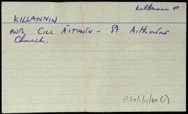
UGA P/P120/1/11/59/1
·
Item
Part of Personal
Index card for the townland of Killaguile, [Cill an Ghaill].
Robinson,Tim![Kill [An Chill]](/uploads/r/university-of-galway-archives/7/b/d/7bde64a92137bc115599aa93a9caf79104ae871f72930f7e6efef808c5cd0a95/300_142.jpg)
UGA P/P120/1/5/25/1
·
Item
Part of Personal
Set of index cards describing some of the local features of the townland of Kill [An Chill]. Included is information from the Congested Districts Board, and the Estate of Alex Thompson. A line from the returns in Griffith's Valuation is also included. Included are descriptions of Cill Fhlannáin, Carraig an Iasc, Loch na hAille Gairbhe, Cnoc na Cille, The Manor, Tobar Fhlannáin, and Loch na Cille. M. King is one of the local people credited with providing information.
Robinson,Tim,King,M.
UGA P/P120/1/6/37/1
·
Item
Part of Personal
Index card giving a description of the townland of Kill, [An Chill]. Included are descriptions of Ross (the eastern half of the townland), Kill Bank, Oileán na Mionán, the national school, Standing Stone, and a detailed note on the local chapel. Included here is a description of unusual grave slabs of concrete decorated with shells. An anecdote involving pirates and an unfortunate local man.
Robinson,Tim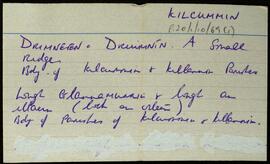
UGA P/P120/1/10/69/1
·
Item
Part of Personal
Set of index cards relating to the civil parish of Kilcummin. Mostly these are notes from the Small Names Index. It mentions specific features of the parish: Druimnín, Loughacloghar, Lough salach a chlochain, Derrygowna Road, Crumlin Bridge, Moor Park, and Srathadán (an island in Lough Corrib).
Robinson,Tim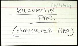
UGA P/P120/1/13/9/1
·
Item
Part of Personal
Overview list of the following townlands within the Civil Parish of Kilcummin, Barony of Moycullen. The cards include the Irish and English language renditions of the townland names.Ardderrynagleragh [Ard doire na gcléireach], Bunscanniff [Bun scainimh], Camas Íochtair [Camus Eighter], Camas Uachtair [Camus Oughter], Cill Bhriocáin [Kilbrickan], Cinn Mhara [Kinvarra], An Cnapach [Crappagh], Cnoc an Daimh [Knockadaw], Cnoc an Phréacháin [Knockaphreghaun], Cnoc na Gairfeann [Knocknagarrivhan], Daimhinish [Dinish], Dereenagusfoor [Doirín na gCos Fuar], Derrough North [Na Doiriú Thuaidh], Doire Bhrios [Derryvrusk], Doire Dhá Bhanbh [Derravoniff], Foirnis [Furnace], Formaoil [Formoyle], Gairfean [Garrivinnach], Glinn chatha [Glencoh], Gleann Mhac Muirinn [Glenicmurrin], Gleann Trasna [Glentrasna], Inis Mhic Cionaoith [Inchamakinna], An Leathchartúr [Halfcartron], Inis Oirc [Inisherk], Inis Mhic Cionaith [Inchamkinna], Lackavrea [Leac Aimhréidh], Leitir Mealláin [Lettermullen], Leitir Móir na Coille [Lettermore], Lurgan [Lorgán], Muiceanach Choille [Muckanaghkillew], Muiceanach Idir Dhá Sháile [Muckanaghederdauhaulia], Úráide [Oorid], Ros Céide [Roskeeda], Ros Muc, An Ros Rua [Rossroe Island], Seana Bhéartha [Shannavara], An Sean Bhaile [Shanvally], Seanana Feola [Shannaunnafeola], Snámh Bó [Snauvbo], An Turlach Mór [Turlough], An Turlach Beag [Turloughbeg], Na hUilinní [Illeny], and Cloon [An Chluani].
Robinson,Tim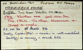
UGA P/P120/1/5/23/1
·
Item
Part of Personal
Set of index cards describing some of the local features of the townland of Keerhaunmore, [An Caorán Mór]. Included are descriptions of Tobar Chaillín, Caorán Dóite, Fuagh na hInnioch, Carraig Fia, and a crossed out card on Loch Beag. John O'Malley and Robert Coneys are credited as being local sources of information.
Robinson,Tim,O'Malley,John,Coneys,Robert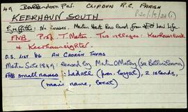
UGA P/P120/1/5/24/1
·
Item
Part of Personal
Set of index cards describing some of the local features of the townland of Keerhaun South, [An Caorán Theas]. Some information from Griffith's Valuation, the Field Name Books, and the 1849 sale of the Martin Estate are included, as well as a brief description of an Island Cashel by the East shore of Ballybwee Lough on the OS. Robinson includes a note to say this feature was not seen.
Robinson,Tim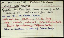
UGA P/P120/1/5/29/1
·
Item
Part of Personal
Set of index cards describing some of the local features of the townland of Keerhaun North, [An Caorán Thuaidh]. Included is a description of Ceann Dólann. M. King is credited with providing some of the information.
Robinson,Tim,Riley,Marky,Mary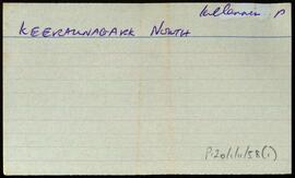
UGA P/P120/1/11/58/1
·
Item
Part of Personal
Index card for the townland of Keeraunnagark North, [Caorán na gCearc Thuaidh].
Robinson,Tim