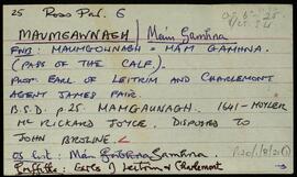
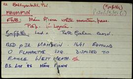
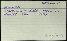
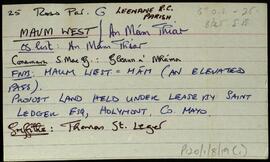
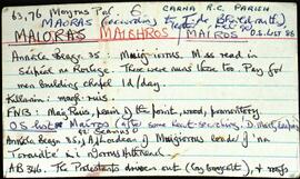
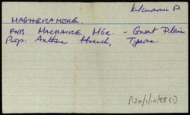
Ireland

Elements area

Taxonomy

Code

Scope note(s)

    Source note(s)

      Display note(s)

        Hierarchical terms

        Ireland

          Equivalent terms

          Ireland

            Associated terms

            Ireland

              667 Archival description results for Ireland

              667 results directly related Exclude narrower terms
              Tooreenacoona
              UGA P/P120/1/3/70/1 · Item
              Part of Personal

              Set of index cards describing some of the local features of the townland of Tooreenacoona, [Tuairín Uí Chuanna]. Included is a description of Máimún, and a note of the return from Griffith's Valuation.

              Untitled
              Tully Beg
              UGA P/P120/1/3/71/1 · Item
              Part of Personal

              Set of index cards describing some of the local features of the townland of Tully Beg. [An Tulaigh Bheag]. Included are descriptions of Renvyle Church and graveyard (Church of Ireland), and a list of the graves there. Also a description of the White Strand, sometimes known as Tullybeg Beach.

              Untitled
              Tullyconor
              UGA P/P120/1/3/72/1 · Item
              Part of Personal

              Set of index cards describing some of the local features of the townland of Tullyconor, [Tulaigh Uí Chonchúir]. Included are description of Derrynasliggaun Lodge (Doirín na Sliogán), a list of the memorials in the Protestant Church at Aasleigh, and Tullyconor Bridge. A Mrs. Willoughby is credited with providing some of the information for Derrynasliggaun Lodge.

              Untitled
              Tully More
              UGA P/P120/1/3/73/1 · Item
              Part of Personal

              Set of index cards describing some of the local features of the townland of Tully More, [An Tulaigh Mhór]. Included are descriptions of the Coastguard Station, Tullymore Point, Trá na mBan, Tully Lough, the village of Tully, and Tullyroe.

              Untitled
              Ungwee
              UGA P/P120/1/3/74/1 · Item
              Part of Personal

              Set of index cards describing some of the local features of the townland of Ungwee, [Iong Gaoithe]. Several different spellings and versions of the names are included in the Field Name Books, including Iongaid, Ungbuide, Ongbuide yellow hill. Cards are devoted to features including pre-bog walls (no further information on this card), Lough Naguroge (Loch na n-guiróg). Mike Gibbons credited with providing some of the information.

              Untitled
              Renvyle
              UGA P/P120/1/3/75/1 · Item
              Part of Personal

              Set of index cards describing some of the local features of the townland of Renvyle, [Rinn Mhaoile]. A note on the O'Halloran family of Renvyle, and a note referring to William Larminie's 'West Irish Folk Tales and Romances'.

              Untitled
              Ardbear
              UGA P/P120/1/4/1/1 · Item
              Part of Personal

              Set of index cards describing some of the local features of the townland of Ardbear, [Aird Bhéarra]. Included are descriptions of Owenglen Falls, (the site of Daniel O'Connell's meeting in 1843, and home to a lodge which featured in 'The Quiet Man'). Ardbear Lake, Cuan Airdbéara (where some members of the Coney family resided), Creighton's Hill, Ardbear Bay oyster beds, Tobberbeggan Holy Well, Ardbear Monastery, an Orphanage, Clifden Monastery, Owenglin River, Dooneen (Dúinín), The Salt Lake, Clifden Community School, Ardbear House (once a hotel, and later a secondary school run by the Franciscans), Rockglen House, South Hill, Malmore House (gives an overview of the colourful pasts of some of Meall Mór's residents), and Rushnacarra Lodge.

              Untitled
              Derrycunlagh
              UGA P/P120/1/4/2/1 · Item
              Part of Personal

              Set of index cards describing some of the local features of the townland of Derrycunlagh, [Doire Chunlaigh]. Included are descriptions of Loch na mBreac Dearg, Loch Thomáis Noel, the Trackway between Bog Road and Lough Derrycunlaghbeg, Na Creaga Beaga, Loch na mBreac Mór, Na Creaga Móra, Derrycunlagh Lake, Lough Nasoodery East (adjacent to a hillock known locally as meall a púdaire/tsúdaire), Roundstone Bay, Clochar an Chait, Loch an Éin Mhóir, Loch an Madra Uisce, Loch Fada na gCreag, Loch Salach Mór/Beag, Loch Srutháin Caon, Boithín, Half-Way House (home of Anna More or Anna Connolly, and Loch an Ghadaí. A letter from Michael Gibbons in February 2000, Tom Macdonagh of Roundstone, Paddy Linnane of Roundstone, and the Connery brothers of Beaghcauneen are credited with providing some of the local information.

              Untitled
              Derrylea
              UGA P/P120/1/4/3/1 · Item
              Part of Personal

              Set of index cards describing some of the local features of the townland of Derrylea, [Doire Liath]. Included are descriptions of the Derrylea Mines, the Island Lough, Loch Fada, Joyce's Imleach, Derrylea Hill, and Loch an Arbhair are included in the descriptions. John Joyce of Emlaghmore, and Ritchie Savagh of Gowlan West are credited with providing the local information.

              Untitled
              Faul
              UGA P/P120/1/4/4/1 · Item
              Part of Personal

              Set of index cards describing some of the local features of the townland of Faul, [Na Fáil]. Islandview House, Rabbit Island, and Coney's Folly (a note to say nothing visible on the ground, but describes what would be a good site for a folly). Rory Lavelle is credited with providing some of the local information.

              Untitled