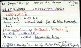
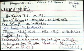
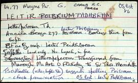
Set of index cards describing some of the features of the townland of Gabhla [Gowla]. Some historical information from Griffith's Valuation, and from the 1849 sale of the Martin Estate is included, which notes a salmon fishery was held by Daniel Bowden Smith on lease on Gowla River and lakes. Included in the descriptions are Abhainn Ghabhla (Owengowla), Loch an Duine (occasionally this is named Loch Marú an Duine locally, the site of where a man was killed for the half crown in his pocket), Loch na nOileán (Loughanillaun on the OS, known by the Fisheries as Gowla lake, and locally as Loch Barr na hAbhann), Loch an Aonoileáin, Barr na dTamhnach Gabhla, Loch Crocán na Gaoithe, Loch an Chlochair, Loch na mBreac Geal, Loch na Maidí, Cnoc Seana na Sith (some notes on the confusion behind its name), Coill an Gháigín, Sruthán na Teorann, Gabhla Bay/Cove, Loichiní Choill an Gháigín, Loch Tulaí Buí, Poll Sáile, Loch an Dín, Eas Mór, Gabhla Mór, Loch Fhada, Abhainn Ghabhla Beag, An Cnoc Breac, Loichín Salach, Loch na Tamhnái, Loch an Fhideáin, Loch Cúl an Dhrama, Loichín Caoch, and Gleann Aill an Tarra. Patrick King and Mike Coyne are two local sources credited with providing information.
Untitled