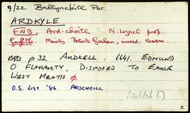
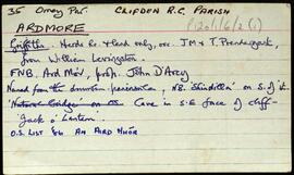
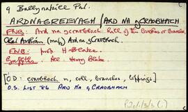
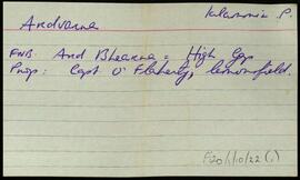
Set of index cards describing some of the local features of the townland of Ardkyle, [Ardchoill]. Descriptions are given of Freaghillaun South (Freegh Island), Carraig Ghéar (Carrigeen South), Cuainin Garbh, Ross Beach, Poll na gColm (Ooeycolum on the OS maps), Glasoileán, Leac na mBó, Leac na Sronna, and Fruaigh Leathan. Some notes are included offering musings on the meanings of the different place names. Paddy Heanue of Letterbeg, and an old man who lives in the last cottage in Ardkyle are credited as providing some of the information therein. A note on a ruined megalith, 25 metres from a cliff ledge. A letter from Mike Gibbons (1988), is credited as being the source of some of the information.
Robinson,Tim,Heanue,Paddy,Gibbons,MikeSet of index cards describing some of the local features of the townland of Ardmore, [An Aird Mhóir]. Included are descriptions of Caladh Mór, the grave of a French sailor buried under rock almost 100 years ago, Duinín, Carraig na hOillaine, Sindile (an islet, Tim Robinson describes the profile as that of a beater, and includes a small sketch), Corrán, and a small cave known locally as 'Jack of the Lanterns'. Patrick Mullen (et al), and Mr. MacDonagh of Eyrephort are credited as being sources of some of the local information.
Set of index cards describing some of the local features of the townland of Ardmore, [An Aird Mhóir]. Included are descriptions of Caladh Mór, the grave of a French sailor buried under rock almost 100 years ago, Duinín, Carraig na hOillaine, Sindile (an islet, Tim Robinson describes the profile as that of a beater, and includes a small sketch), Corrán, and a small cave known locally as 'Jack of the Lanterns'. Patrick Mullen (et al), and Mr. MacDonagh of Eyrephort are credited as being sources of some of the local information.
Robinson,Tim,Mullen,PatrickAerial photographs of promontory fort sites and headlands at Ardmore, including at Ardoginna and Ardocheasty townlands, plus images of the Ardmore Watch Tower and Ardmore Round Tower.
Set of index cards describing some of the local features of the townland of Ard na gCraobhach [Ardnagreevagh]. Included are descriptions of Freaghillaun North, Lúibín an aill, Cathair (a ringfort), a forge, Bóithín na Cathrach, Carraig Léith, Cuainín Mór, Carraig an Bhradáin, Portín na Lachan, Fó Mhainnín, Aice, Ceann na Dumhaí, Cnocán na Sceithí, and Port an Chaisleáin. Several references are given to 'Hidden Connemara' as a source of information for this townland.
Robinson,TimThis file contains research notes and is arranged by Ó Súilleabháin under the following headings: "Coiste Chontae Chiarraí 1915 go 26/10/20"; "Coistí Ceantair" ; "Coiste Ceantair - Maigh Chromtha, Dhún Méanmhara, Laoi"; "Nótaí 1901 - CnaG Sráid Fhearcair" including notebook labelled "Coiste Chontae Chiarraí 1921-39" ; "Eolas ó Leabhar an Sláid (1900-1901)".
Tag / Ref: G60/24/7