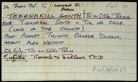
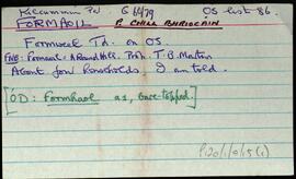
Set of index cards describing some of the local features of Formaoil, [Formweel]. Included are descriptions of Abhainn Fhormaoil, Lough Carrickillawallia, Loch Doirín, the Zion Mór, Loch an Roisín (Lough Cloondola on the OS map), The Rack (a narrow place on the river between two lakes. The manager of the fishery had a sluice he would open to encourage salmon), Loch Fhormaoil, Holy Well, Formoyle Lodge, Loch an Chriathraigh, and Cnoc Fhormaoil. Mr. Walsh of Muireanach na Coille, Helen Spellman, and Matthew Costelloe of Formaoil are credited as being local sources of information.
Robinson,Tim,Spellman,Helen,Costelloe,MatthewHoly Well
2 Archival description results for Holy Well
2 results directly related
Exclude narrower terms
UGA P/P120/1/7/15/1
·
Item
Part of Personal
UGA P/P120/1/8/25/1
·
Item
Part of Personal
A set of index cards outlining briefly some of the local features of the townland of Teernakill South, [Tír na Cille Theas]. Included are descriptions of Binn Ramhar, Droichead an Easa (Shaughnessy's Bridge on the OS map), the Copper mines, a holy well, lake, and bridge, Tulachaí, Mám Aodha, Tír na Cille River, Aill na Lady, Corcóg, Log an tSamh, Bucán, Loigín Dóite, Meall, Binn Chaoinghí, Caobóg, Cúl an Easa, Na Cruic Breaca, and Binn Mhór. Will Crawford from Mám, Nora Keane, Mary Keane, Willy Sutcliffe, and a person identified as Lydon from Bun a Bhucáin are credited as being local sources of information.
Robinson,Tim,Crawford,Will,Keane,Nora,Mary,Sutcliffe,Willy