Set of index cards describing the local features of the townland of Muínis [Maínis on logainm.ie, translated into English as Mweenish Island]. Note about ambiguity between Moyrish and Muínis in Simington's 'Books of Survey and Distribution'. Included are descriptions of Feithearnach, Carraig na Blaodhaí, a detailed note on the Estate of Colonel Nolan, sitting MP for North Galway. An Chreig Mhóir, An Sián, a causeway, Trá na mBád, An Cuainín, Muc Ghainimh, Maidhm Mhairtín Thaidhg, Crompán an Chúir, Stupóg an Táilliúrn, Leathrach na mBran (a fishing spot), Leaba Dhiarmaid, Bhéard na gCathasach. An Cuan Mór, Poll an Chora, Aill Chaltha an Aifrinn, Aircín an Mhaide Rámhair, Rinn Bheiglach, Ardskillan, Cibh an Bhéartha, Trá na Dumhaí Bige, Trá Fhada, Leic an Mhuinigh, An Ard-Thrá, Maidhin Mhicil Bhuí, An Garraí Mór, Mweenish Lodge, Carraig an Gharraí Aird, Oileán Lachan (Duck Island on the OS maps), An Dumhach Fhionn, An Aircín Thoir, An tSáilín, Oileán an Chara, Aircín Thiar, Crompán an Liamháin, Tóin Roisín, Trá an Bhoilg, Trá Dheiscirt, An Trá Mhóir, Tobar Cholm Cille, Mac Con Iomaire, Tobar na Seacht nIníon (well of the seven daughters on the OS maps), Loch Varáin, Carraig na mBan, Inis tSruthair, Tonn Uí Floinn, Tóin Ghairbh, An Meall Rua, Cartúr, Portach Mhuínse, Carraig na bPortán, Tobar Cholm Cille, Garraí na nGéabha, Leic na Gharraí Ghainimh, Bóithrí na Trá, Na Corainneacha, Leic na Cora, Coréal Mheaircín, and Clochar an Mhadra Uisce. The word 'local' is written on several of the index cards, indicating that Tim Robinson would have spoken with members of the community, and taken their knowledge of places and spellings in compiling this information. Two individuals are named, Sgt. P O Conaola, and M King of Inis Ní. Several other sources are credited, including Brother Conal Thomas's book 'The Land for the People: The United Irish League and Land Reform in North Galway, 1898-1912', Liosta Focal, Chroí Chonamra, and Nimmo's 1825 map.
Robinson,Tim,Conaola,P. O.,Sgt.,King,M.Connemara
2 Archival description results for Connemara
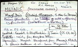
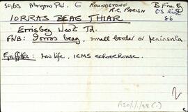
Set of index cards describing the physical features of Iorras Beag Thiar [Errisbeg West]. Located in Moyrus Civil Paris, and the Roman Catholic Parish of Roundstone. The features described include a series of rocks located close to the shorelines of Dog's Bay and Mutton Island. These are Carraig na Feadóige, Ceann an Chlochair, Carraig na Raghailligh, Carraig á Scanain, Carraig an rudáin, Carraig an gliomach, Dréimire. Historical features of the area are also described, Iarbhalla, The Dugout (a hiding place during visits from the Black and Tans). Various other locations described include The For, Cnocán Mhuintir Uí Mháille, Meall na bhPréachán, Port na Feadóige, Muc Ghainimh, a note on local grazing rights around Dog's Bay, Mucranagh, The Big House (anecdotal story included here), Gleann Thaidhg Bháin, Gleann Archaí, The Banks, The Béalóg, Loch Seánólaí, Trá Bheag, Trá Gharbh, Fód Ghlas, Oileán Mhuilt (Mutton Island on the OS and in the Field Name Book), Goirtín, Poll Dog (Dog's Bay), Feadóg (Gorteen/Gurteen Bay), Carraig Chabhalta, Trá Mhartáin, and Carraig Tholta. Some local sources are credited with providing information. These are, Delia Folan, L and B de Courcy, Tom MacDonagh, John King, Joe Rafferty, Festy Keane, Ronán Henderson, an un-named elderly Roundstone lady, Bridy Folan, and Paddy MacDonagh.
Robinson,Tim,Folan,Delia,Courcy,L. de,B. de,MacDonagh,Tom,King,John,Rafferty,Joe,Keane,Festy,Henderson,Ronán,Bridy,Paddy