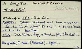
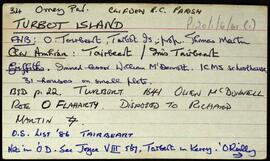
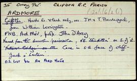
Set of index cards describing some of the local features of the townland of Ardmore, [An Aird Mhóir]. Included are descriptions of Caladh Mór, the grave of a French sailor buried under rock almost 100 years ago, Duinín, Carraig na hOillaine, Sindile (an islet, Tim Robinson describes the profile as that of a beater, and includes a small sketch), Corrán, and a small cave known locally as 'Jack of the Lanterns'. Patrick Mullen (et al), and Mr. MacDonagh of Eyrephort are credited as being sources of some of the local information.
Robinson,Tim,Mullen,PatrickConnemara
3 Archival description results for Connemara
Set of index cards giving a description of the townland of Inishturk, [Inis Toirc]. Included are descriptions of Black Stick (a hill), Cara Chnoic, Baile Thoir, Baile Thios, Cuainín, Reilg, Caibidie, An tOileán Íseal, Glasoileán, Caladh Mór, Cnoc na Móna, Maoilín, Fuach Mhór, Carraig Mhuiris, and Tóin Rua. Mr. Hannon or Inishturk, and Mr. McDonagh of Eyrephort are credited with provoding some of the local information.
Robinson,TimSet of index cards giving a brief description of Turbot Island, [Tairbeart]. A note on the last inhabitants of Turbot Island, around 50 or so people who left the island in winter 1978/79 after a particularly tough winter when 3 men drowned. A note on when the island first got electricity. Also included are descriptions of Caladh Mór, Carraig an Duibhéin, Maoileán an Mhadra, Maoileán na nÉan, Carraig Leathan, Fuach Black, Carraig a Graiflin, Cuainín, Bantrach Bhuí, Réileán, Cairín, Poll Trá, Dúilic, Tóin an Oileáin, Cois, Carraig na bPortán, Carraig Gheagáin, Lochtaí, Lochán na Móna, Leic, Carraig na Rón, and Úbhra Mhór and Úbhra Bheag. Festy Conneely (once an islander), John Price of Eyrephort, and the un-named residents of the nearest house are credited with providing some of the local information.
Robinson,Tim