Connemara

Elements area

Taxonomy

Code

Scope note(s)

    Source note(s)

      Display note(s)

        Hierarchical terms

        Connemara

          Equivalent terms

          Connemara

            Associated terms

            Connemara

              3 Archival description results for Connemara

              3 results directly related Exclude narrower terms
              An Coillín
              UGA P/P120/1/2/10/1 · Item
              Part of Personal

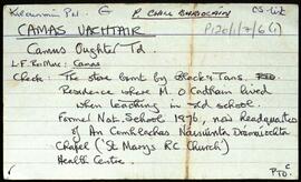
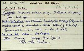
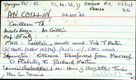
              Set of index cards describing some of the features of the townland of An Coillín [Cuilleen]. Included in the descriptions are Mass Rock, Tóin Naigín, Caladh Mhacaí, Gleann an Tobair, a cave sometimes known as Poll an Phíobaire, An Choraínn, Abhainn an Mhuilinn, Abhainn an Choillín, Lough Corker, Gleann an tSéideáin, Loch na Tulaí Buí, An Píosa Réidh, Loch an Amoileáin, Carraig Eanoinn, Aill a Gharrett, Poll an Mhianaigh, Cuan an Choillín, An Coréal, Roisín an tSamha, Loch an Gharraí, Scailp Mhór, An Sean-gharraí, Poll an Chiste, Garraí Thaidhg Mhór, Loch Mhaoilre, and Cnoc an Choillín. E O'Neill, Sgt. P O'Conghaile/Conaola, and Bríd Bean Uí Chonaola credited with providing some of the information.

              Robinson,Tim,O'Neill,E.,O'Conghaile/Conaola,P.,Sgt.,Uí Chonaola,Bríd Bean
              Camas Uachtair
              UGA P/P120/1/7/6/1 · Item
              Part of Personal

              Set of index cards describing some of the local features of Camas Uachtair, [Camus Oughter]. Included are descriptions of Foirnís (in the area where the chapel is now. The furnace burned timber from Leitir Mór na Coile, and was the site of a local iron ore industry in the mid 18th century. Also included are descriptions of Cnoc Chamais (Camus Hill), An Tamhnach, Loch an Níocháin, the local chapel, Oileán na Scailpe, Príosún Chamais, Lín an Ghoirt Runna (sometimes referred to locally as Poll an Ghoirt Runna), Loch an Fhealltóra, Loch na Foirníse, An Chora Fhada, Cora na Móna, Poll an Phíobaire, Stór Chamais (which was burned by the Black and Tans in 1921), An Snáimhín, Loch na Lannach, Cnocán na gCloch, Cora an Fhealltóra, Bóthar na Trinse, Cnocán an Tobac, Béal Chamais, Cuan Chamuis, Garmain Chaoráin Aodh, Cora na mBád, Boithrín Bháibín, An Chora Bháin, Seana Bháird, Na Corannaí, Cnoc na Sciortán, Crompáin Láibe, An Claí Nua, and Céibh na mBád. Fr. Leo Ó'Morchán of Rosmuc, Pater Flaherty of Camas, and a reference to 'Órán na nIontas' are credited as being sources of some of the local information.

              Robinson,Tim,Ó'Morchán,Leo,Pater Flaherty
              Cregg
              UGA P/P120/1/6/18/1 · Item
              Part of Personal

              Set of index cards describing some of the local features of the townland of Cregg, [An Chreig]. Included are descriptions of Lough Nahillion (na h-uillin), the Children's Burial Ground, Poll an Phíobaire, Corach, Aill na Síog, Aill Mhairtín, Eas Mór, Aill an 'Challenge', Keelogs, Tulaigh tSrutha, Marble Quarries, and Lower Cregg Falls. Rory Lavelle is credited with providing some of the local information.

              Robinson,Tim,Lavelle,Rory