Connemara

Elements area

Taxonomy

Code

Scope note(s)

    Source note(s)

      Display note(s)

        Hierarchical terms

        Connemara

          Equivalent terms

          Connemara

            Associated terms

            Connemara

              21 Archival description results for Connemara

              21 results directly related Exclude narrower terms
              Aill Bhreac
              UGA P/P120/1/5/1/1 · Item
              Part of Personal

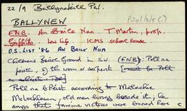
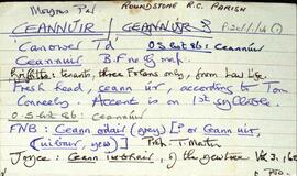
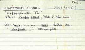
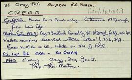
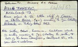
              Set of index cards describing some of the local features of the townland of (An) Aill Bhreac, [Aillebrack]. Included among the set of cards are descriptions of Carraig an Lios (more familiar to locals as Carraig Áilis, or Ailice's rock, used as a place to bury children until 1803), Split Rock, Cnocán Breac (Guaire na bpáistide in the Field Name Book), Holy Well and Mass Rock, Cé Bhun Abhann, Maidhm Cromaill (Cromwell Shoal), Straw Beach Island, Loch Caffrey, Bóithrín Beag, Lochán Buí, Oileán Ura (Illaunurra), Loch an Doirín, Sand Lake, Dóilainn Harbour, Cnocán na hAille Brice, Horse Island, the Well of the Seven Daughters (sometimes known locally as the Well of the Seven Sisters), Midden, Creig, Carraig Cumair, Carraig an Ghamhna (Calf Island), Buachaill (Boughillcarrickcark/Bóchaill), Carraig an Locháin, Carrach an tSeoighe, Corrach an tSrutha, Corrán, Tóin an Rosa, Carraig an Fhuaruisce, the Coastguard Station, Murlach, For Buaile, the Children's Burial Ground, Carraig an Fhioruisce, Corrán Beag, and Corrán Mór. Seán King of Ballyconneely, Martin O'Malley of Roundstone, and local man Jim O'Malley are credited with providing some of the information.

              Robinson,Tim,O'Malley,Martin,King,Seán,Jim
              Ballynew
              UGA P/P120/1/3/5/1 · Item
              Part of Personal

              Set of index cards describing some of the local features of the townland of Ballynew [An Baile Nua]. Descriptions are given of a 'pair of standing stones', Fuaigh an Sconsa (Ooeyasconsa on the OS maps, and known locally as Fo na Sconsaí), Fó na Bróinge (Tim Robinson believes the cove may be named for its boot-like shape), Fó na Labhráis (Ooeylaunlauraush on the OS maps), Fó na Bhistí, Fuaigh an Duine Mhairbe (Ooeywaria on the OS maps), Binn Ghlais, Fó an Uisce, Fó an Bhradáin, Megalithic tombs close to the Children's Burial Ground, Lios (the site of the former Mission School), and the Shrine, which marks the traditional site of St. Ceannan's beheading. J O'Toole of Moyard, Mr. Heanue of Bundouglas, and Con Mullen of Ballynew are credited with providing some of the information.

              Robinson,Tim,O'Toole,J.,Mullen,Con
              Ceannúir
              UGA P/P120/1/1/14/1 · Item
              Part of Personal

              Set of index cards describing the physical features of Ceannúir [Canower]. Descriptions given are of Tulach Bhuí, Paiste, Cora na gCruicíní, Tráíní, Bealach an Ghiorria, Oileán na Táimhe, Cora an Oileáin, Cora na hAbhann, Tulach and Aill na Tulaí, Staca, Portach Bán, Caladh Pheadair Mhór, Garraí Mór, Aill Uí Ghábháin, Cora Shéamus Uí Chonaire, Cora Mhongáin, Gleann na gCoileach, Cora Leachta, Rua Oileán, Children's Burial Ground and Ceannúir Harbour. Sources of information credited are Tom Conneely, and Joe Joyce, a native of Ceannúir.

              Robinson,Tim,Conneely,Tom,Joyce,Joe
              Ceapach Chuais
              UGA P/P120/1/1/13/1 · Item
              Part of Personal

              Set of index cards describing physical features and monuments in Ceapach Chuais [Cappaghoosh]. Descriptions given are of Lough Cappaghoosh, the Children's Burial Ground, Scanadh Ceilt (Owengarre Lough on OS maps, between Cappaghoosh and Lettershinna), Loch na Mionnán (between Cappaghoosh, Lettershinna and Derryadd), Loch an Imligh, Stacaí, Loch Doire Croise, Loch Uí Mhongáin, Loch an Ghé, and a roadside monument at the east end of Lough Tounagh. Sources credited with providing informationi include Jo Creane, Jo Mannion of Garroman, and Mr. O'Malley of Bóth Íseal

              Robinson,Tim,Creane,Jo,Mannion
              Cregg
              UGA P/P120/1/6/18/1 · Item
              Part of Personal

              Set of index cards describing some of the local features of the townland of Cregg, [An Chreig]. Included are descriptions of Lough Nahillion (na h-uillin), the Children's Burial Ground, Poll an Phíobaire, Corach, Aill na Síog, Aill Mhairtín, Eas Mór, Aill an 'Challenge', Keelogs, Tulaigh tSrutha, Marble Quarries, and Lower Cregg Falls. Rory Lavelle is credited with providing some of the local information.

              Robinson,Tim,Lavelle,Rory
              Culliagh More
              UGA P/P120/1/8/7/1 · Item
              Part of Personal

              A set of index cards outlining some of the local features of the townland of Culliagh More [Coilleach Mhór]. A note on Áitin na Leanbh (a children's burial ground), located near the cottage of Sabina (Bina) McLochlainn. Other hillsides and grave stones are located in fields near her cottage, one said to be the grave of Fionn MacCumhall's wife Bána. A brief note on Taob na Moinge, and a credit to Arthur Joyce for information on this.

              Robinson,Tim,Joyce,Arthur
              Derreennagusfoor
              UGA P/P120/1/7/11/1 · Item
              Part of Personal

              Set of index cards describing some of the local features of Derreennagusfoor, [Doire na gCos Fuar]. A note on the origin of the name. A local story has it that a herd hand went into the woods there, and was killed and eaten by a bull. All they found of him was his boots with the feet still in them. Brief descriptions are given of the sulphur mine, and the infant's burial ground. Paddy Folan of Scríb is credited as being a local source of information.

              Robinson,Tim,Folan,Paddy
              Derrynea
              UGA P/P120/1/11/10/1 · Item
              Part of Personal

              Set of index cards detailing some of the local features of the townland of Derrynea, [Doire an Fhéich]. Secondary sources consulted include Griffith's Valuation, Petty's map, Simington, and the Martin Estate Sale Map. Brief descriptions are given of the Costello Fishing Club, Teach na Cúirte, Lower Costello Fishery, Costello Lodge (which was burnt in the Civil War, and later rebuilt), Costelloe and Fermoyle Fisheries Co., Abhainn Chasla, Cuan Chasla, Cottage Pool, the lead mine, Tobar Naomh Phádraic, Loch an Mhianaigh, Loch Uí Chadhain, Loch Bharr an tSrutháin, Casla, the Children's Burial Ground, and Aill na Graí. Robinson credits Professor Wilkins' book as a source of information.

              Robinson,Tim
              Derryvealawauma
              UGA P/P120/1/1/24/1 · Item
              Part of Personal

              Set of index cards describing some of the physical features of Derryvealawauma [Doire Bhéal an Mháma]. Included in the descriptions are Cnoc Doire Bhéal an Mháma, Port an Dúín, Log Mhám Té, the Children's Burial Ground, Máméan, and Bun an Chnoic. A note on Bun na gCnoc and its status as a Gaeltacht during the Recess school boycott. Local Tamhnach Mór and Leitheanach people are credited with providing some of the information.

              Robinson,Tim
              Emlagh
              UGA P/P120/1/6/24/1 · Item
              Part of Personal

              Set of index cards giving a description of the townland of Emlagh, [Imleach]. Included are descriptions of Sellerna Church, the rectory of which was demolished, and its outhouses converted into the house now called 'The Old Rectory'. The headstone of a sailor in the British Navy is to be found here. Some information on the church's last minister. Also described are Sellerna School, Sellerna Bay where a wedge grave known as Leaba Dermot can be found, and the children's burial ground also found by the bay.

              Robinson,Tim