Connemara

Elements area

Taxonomy

Code

Scope note(s)

    Source note(s)

      Display note(s)

        Hierarchical terms

        Connemara

          Equivalent terms

          Connemara

            Associated terms

            Connemara

              559 Archival description results for Connemara

              559 results directly related Exclude narrower terms
              UGA P/P120/1/10/86/1 · Item
              Part of Personal

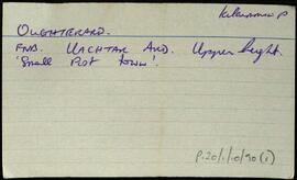
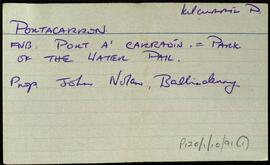
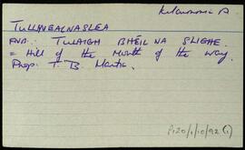
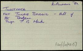
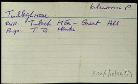
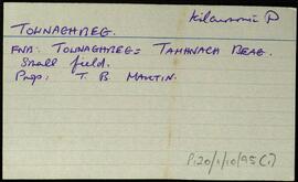
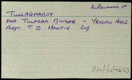
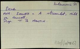
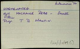
              Index card relating to the townland of Moyvoon East and West, [Maigh Mhaon Thoir agus Maigh Mhaon Thiar].

              Robinson,Tim
              Muiceanach Choille
              UGA P/P120/1/7/29/1 · Item
              Part of Personal

              Set of index cards describing some of the local features of Muiceanach Choille [Muckanaghkillew]. Included are descriptions of Doire na Bó, Loch Muiceanach, Cnocán na Laoi, Conga, and Loch Roisín. Helen Spellman, and local man, Mr Walsh are credited as being local sources of information.

              Robinson,Tim,Lynch,Martin
              UGA P/P120/1/7/28/1 · Item
              Part of Personal

              Set of index cards describing some of the local features of Muiceaneach Idir Dhá Sháile, [Muckanaghederdauhaulia]. Included are descriptions of An Droimín, An tSruthair, Crompán Beag, Barr na Cora, Cora na Gaoithe, Crompán Mór, An Crompán, Mulán Dhiarmuid, and Cara na gCaorach.

              Robinson,Tim,Spellman,Helen
              Muínis
              UGA P/P120/1/2/34/1 · Item
              Part of Personal

              Set of index cards describing the local features of the townland of Muínis [Maínis on logainm.ie, translated into English as Mweenish Island]. Note about ambiguity between Moyrish and Muínis in Simington's 'Books of Survey and Distribution'. Included are descriptions of Feithearnach, Carraig na Blaodhaí, a detailed note on the Estate of Colonel Nolan, sitting MP for North Galway. An Chreig Mhóir, An Sián, a causeway, Trá na mBád, An Cuainín, Muc Ghainimh, Maidhm Mhairtín Thaidhg, Crompán an Chúir, Stupóg an Táilliúrn, Leathrach na mBran (a fishing spot), Leaba Dhiarmaid, Bhéard na gCathasach. An Cuan Mór, Poll an Chora, Aill Chaltha an Aifrinn, Aircín an Mhaide Rámhair, Rinn Bheiglach, Ardskillan, Cibh an Bhéartha, Trá na Dumhaí Bige, Trá Fhada, Leic an Mhuinigh, An Ard-Thrá, Maidhin Mhicil Bhuí, An Garraí Mór, Mweenish Lodge, Carraig an Gharraí Aird, Oileán Lachan (Duck Island on the OS maps), An Dumhach Fhionn, An Aircín Thoir, An tSáilín, Oileán an Chara, Aircín Thiar, Crompán an Liamháin, Tóin Roisín, Trá an Bhoilg, Trá Dheiscirt, An Trá Mhóir, Tobar Cholm Cille, Mac Con Iomaire, Tobar na Seacht nIníon (well of the seven daughters on the OS maps), Loch Varáin, Carraig na mBan, Inis tSruthair, Tonn Uí Floinn, Tóin Ghairbh, An Meall Rua, Cartúr, Portach Mhuínse, Carraig na bPortán, Tobar Cholm Cille, Garraí na nGéabha, Leic na Gharraí Ghainimh, Bóithrí na Trá, Na Corainneacha, Leic na Cora, Coréal Mheaircín, and Clochar an Mhadra Uisce. The word 'local' is written on several of the index cards, indicating that Tim Robinson would have spoken with members of the community, and taken their knowledge of places and spellings in compiling this information. Two individuals are named, Sgt. P O Conaola, and M King of Inis Ní. Several other sources are credited, including Brother Conal Thomas's book 'The Land for the People: The United Irish League and Land Reform in North Galway, 1898-1912', Liosta Focal, Chroí Chonamra, and Nimmo's 1825 map.

              Robinson,Tim,Conaola,P. O.,Sgt.,King,M.
              Mullaghglass
              UGA P/P120/1/3/54/1 · Item
              Part of Personal

              Set of index cards describing some of the local features of Mullaghglass, [An Mullach Glas]. Included are descriptions of Fuaigh Ghainmheach (pronouced Fó Annie by some), Fuaigh an Duine, Fuaigh an Phréacháin, Lios, Fuaigh an gColm, Fuaigh an Fhíoruisce, Teach an Síog, Keeraun Riber, Mullaghglass, Poll an Ghainimh, Mullaghglass House, Mullaghglass River, Clachmhaoil, Fuaigh Mhór, and Cillín (the Infant's Burial Ground). Local man Paddy Hession, Mr Coy, and John Coyne are credited with providing some of the information.

              Robinson,Tim,Hession,Paddy,Coyne,John
              Munga
              UGA P/P120/1/5/33/1 · Item
              Part of Personal

              Set of index cards describing some of the local features of the townland of Munga, [Na Monga]. Some notes about the Geraghty family taken from the Land Commission Record, and Griffith's Valuation. Included are descriptions of Munga Lodge, once the property of the Frewins, who were related through marriage to Churchill, and were driven out by the IRA in 1921 according to Mike Gibbons. A note on Colonel Frewin, and the IRA letter. Also included are descriptions of Derrychorraun River, Tulach, Diarmuid, Joyce's Garden, Fr. Miley's Rock, Cró Chait, Mearing Lake, Councillor (a small lake, the name is used by fishermen), and Loch Roisín na Mionnán. Rory Lavelle, Mikey Fitz, John Joyce, Ritchie Savage, and the Connery brothers of Beaghcauneen are credited with providing some of the local information.

              Robinson,Tim,Conneely,John Abbie,O'Malley,John
              Munterowen East
              UGA P/P120/1/8/23/1 · Item
              Part of Personal

              A set of index cards outlining briefly some of the local features of the townland of Munterowen East [Muintir Eoghain Thoir]. Included are descriptions of An Claí Trasna (a site of action during the Muintir Eoin battle), a note on the O'Malley family, Aill na bPúiríní, An Aill Riabhach, Tobar na Seacht nÍníon, Roighne Mhór, Pádraig Ó'Máille's house, Cnocán na Móna, and a note on a bridge in the town. Mr. Joyce, a local man is credited as being a local source of information.

              Robinson,Tim
              Munterowen Middle
              UGA P/P120/1/8/22/1 · Item
              Part of Personal

              A set of index cards outlining briefly some of the local features of the townland of Munterowen Middle [Muintir Eoghain Láir]. Barr Eidhneáin, The Parks, Torán, Loigín, the Maam Sheep Research Station, and Roighne Bheag are briefly described.

              Robinson,Tim
              Munterowen West
              UGA P/P120/1/8/24/1 · Item
              Part of Personal

              A set of index cards outlining briefly some of the local features of the townland of Munterowen West [Muintir Eoghain Thiar]. Included are a description of Joyce's Grove, and a note about proprietorship in the area over the last two centuries.

              Robinson,Tim
              Murvey
              UGA P/P120/1/1/49/1 · Item
              Part of Personal

              Set of index cards describing some of the features of Murvey [Muirbheach/Muirbhigh]. Included are descriptions of Murvey Wood, Na Fáinairí, Boilg Mór, Fuaigh na Críghe, Fuaigh Mhór, Trosc, Loch Caladh na nOileán, Murvey Copper Mine, the Little Beach, Grey Rock, Fuaigh na gColm, Scoil Mhuirbhigh, Meall, Fuaigh Scardáin, Cnoc Maoimh, the Limekiln, Loch na Caillí, Murvey Rock, Caladh Bháid, Murvey Lodge, Carraig Muirbhigh, The Fáinaire, and White Beach. Local sources credited with providing information include Tom McDonagh, Paddy McDonagh, Noel King a fisherman in Roundstone, Conroy, Joe King, and Joe Rafferty.

              Robinson,Tim,McDonagh,Tom,Paddy,King,Noel,Joe,Rafferty