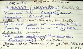
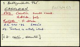
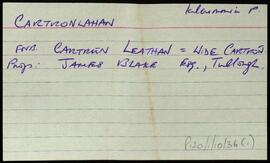
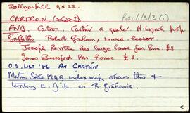
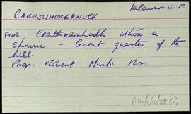
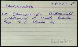
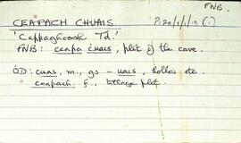
Set of index cards describing physical features and monuments in Ceapach Chuais [Cappaghoosh]. Descriptions given are of Lough Cappaghoosh, the Children's Burial Ground, Scanadh Ceilt (Owengarre Lough on OS maps, between Cappaghoosh and Lettershinna), Loch na Mionnán (between Cappaghoosh, Lettershinna and Derryadd), Loch an Imligh, Stacaí, Loch Doire Croise, Loch Uí Mhongáin, Loch an Ghé, and a roadside monument at the east end of Lough Tounagh. Sources credited with providing informationi include Jo Creane, Jo Mannion of Garroman, and Mr. O'Malley of Bóth Íseal
Robinson,Tim,Creane,Jo,MannionConnemara
559 Archival description results for Connemara
Set of index cards describing the physical features of Ceannúir [Canower]. Descriptions given are of Tulach Bhuí, Paiste, Cora na gCruicíní, Tráíní, Bealach an Ghiorria, Oileán na Táimhe, Cora an Oileáin, Cora na hAbhann, Tulach and Aill na Tulaí, Staca, Portach Bán, Caladh Pheadair Mhór, Garraí Mór, Aill Uí Ghábháin, Cora Shéamus Uí Chonaire, Cora Mhongáin, Gleann na gCoileach, Cora Leachta, Rua Oileán, Children's Burial Ground and Ceannúir Harbour. Sources of information credited are Tom Conneely, and Joe Joyce, a native of Ceannúir.
Robinson,Tim,Conneely,Tom,Joyce,JoeSet of index cards describing some of the local features of the townland of Cashleen [Caislín], namely the Church of the Seven Daughters, and a Court Tomb, indicated on the OS maps as the Giant's Grave, and according to Tim Robinson's notes, is closer to being a portal tomb.
Robinson,TimTwo index cards relating to the townland of Cartronlahan, [An Cartúr Leathan].
Robinson,TimSet of index cards describing some of the local features of the townland of Cartron [An Cartún]. Included are a brief history of Cartron House and its ownership, and some information about the Scotch Firs planted on the estate. Also described are Baile na Cille, Cartron Island, and Ballynakill Chapel. Mrs. Goodbody and M. Gibbons are credited with providing some of the information.
Robinson,Tim,Gibbons,M.An index card relating to the townland of Carrowndulla, [Ceathrú an Dola].
Robinson,TimAset of index cards describing some of the local features of the townland of Carrowmoreknock, [Ceathrú Mhór an Chnoic].
Robinson,TimTwo index cards relating to the townland of Carrowmanagh, [An Cheathrú Mheánach].
Robinson,TimSet of index cards describing some of the features of the townland of Carna. Description of Annála Beaga, a pub built by a priest, which later sold fishing gear. Included in the descriptions are the RIC Barracks (a fellow of the ruined barracks in Caherciveen), Cúbh an Chrompáin, Poll an Athar Peadar, Teach Phobail Naomh Maire, Idir Dhá Locha, An Sruthán Dearg, Ruaoileán, An Chréibhín, Cora Bharr na hAbhann, Loch na Lannach, Abhainn Bheag, Abhainn na Seainimhe, Loch na Calgaí, Lathach na bhFód, Na Dolachta Móra agus Beaga, Oileán an Fhiaich, Oileán na Scuaibe, Na Searaí, Baile an tSléibhe, An Tulach, Abhainn Charna, Caorán Chárna, Roisín na Tamhnaí, Dothulach, Cluais Ghiorria, and Loch Céim na Caillí. Seán Ó'Ceoinín, a Bourke of An Troscán, J Guairim, Roisín Ní Mainiach, and John Mercer credited with providing some of the information.
Robinson,Tim,Ó'Ceoinín,S.,Guairim,J.,Ní Maithniach,Roisín,Mercer,John