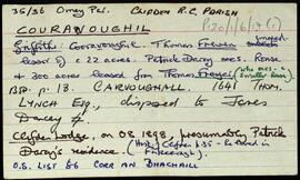
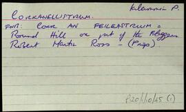
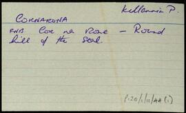
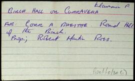
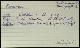
Set of index cards describing some of the local features of the townland of Couravoughil [Corr an Bhachaill]. Included are descriptions of Wood's Field, Simon's Falls, a Megalithic Tomb, and Clifden Glen. Rory Lavelle is credited with providing some of the local information.
Robinson,Tim,Lavelle,RoryConnemara
559 Archival description results for Connemara
Two index cards relating to the townland of Corranellistrum, [Corr an Fheileastraim].
Robinson,TimThree index cards relating to the townland Cora Bheithe [Curraveha or Birchhall].
Robinson,TimSet of index cards describing some of the local features of the townland of Coorhoor/Courhoor, [An Corrbhóthar]. Included are a description of a Crannóg, a pre-bog wall, and Scailp Val, named after Valentine Jordan, a notorious character who fled here from Mayo in 1798. Mike Gibbon is credited as being a local source of information.
Robinson,Tim,Gibbons,MikeSet of index cards describing some of the local features of the townland of Coolacloy, [Cúl an Chlaí]. Included are descriptions of Hog Island, the Coast Guard Station, Cuan an Bhaidhe, Oileán na nÚan, Cúl an Chruit, Tiompán, Maol an Bhreallaigh, The Boat Rock, Cuan na Loinge, Carraig an Tí, Tóin na Leachtaí, and Béal an tSrutha. Local man Patrick Joyce is credited with providing some of the local information.
Robinson,Tim,Joyce,PatrickSet of index cards describing some of the features of the townland of Coill Sáile [Kylesalia]. Features described include Carraig an Chomair, Crompán Choille Sáile, Sruthán na mBrácaí, An Chara Dhubh, Flannery Bridge, Cloch na dTaibhsí, An Garraí Graf, An Meall, Crompán Thaidhg na Buile, Na Caisleáin, Cora Ró Dúgáin, Meall Gorm, Ros Cam, Crompán Lannach, Aill Uaithne, An Criathrach Mór, Loch na Teorann, Cloch Ádhbhach, Ros Dubhgáin, and Tobar Cholm Cille. Pat Sullivan, Professor Seán de Courcy, Seán Dundass, Pádraic MacDonncha, and Máire Canavan all credited with providing information.
Robinson,Tim,Sullivan,Pat,Courcy,Seán de,Dundass,Seán,MacDonncha,Pádraic,Canavan,MáireSet of index cards describing some of the local features of the townland of Cnocnaraw [Cnoc na Rátha]. Descriptions are given of Crocnaraw, formerly known as Rockfield House, which was an orphanage run by Protestant clergymen known as The Forty Boys. Two white quartz boulders known as the Standing Stones, an enclosure, and Maam Green are also described. Mike Gibbons is credited as being a source of some of the information.
Robinson,Tim,Gibbons,Mike