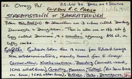
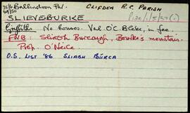
Connemara

Elements area

Taxonomy

Code

Scope note(s)

    Source note(s)

      Display note(s)

        Hierarchical terms

        Connemara

          Equivalent terms

          Connemara

            Associated terms

            Connemara

              559 Archival description results for Connemara

              559 results directly related Exclude narrower terms
              Tievegarriff
              UGA P/P120/1/3/65/1 · Item
              Part of Personal

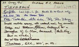
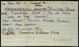
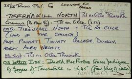
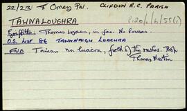
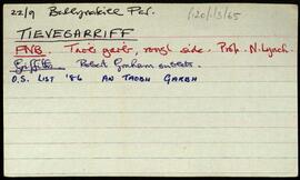
              Index card relating to the townland of Tievegarriff, [An Taobh Garbh]. Brief information derived from Griffith's Valuation, and the relevant Field Name Book.

              Robinson,Tim
              Tievebaun
              UGA P/P120/1/6/58/1 · Item
              Part of Personal

              Set of index cards giving a brief description of Tievebaun, [An Taobh Bán]. Included are descriptions of Binn Bhreac, and Magairle (a peak). John Mannion of Barnanoraun, and Teresa Mannion are credited as providing some of the local information.

              Robinson,Tim
              Teernakill South
              UGA P/P120/1/8/25/1 · Item
              Part of Personal

              A set of index cards outlining briefly some of the local features of the townland of Teernakill South, [Tír na Cille Theas]. Included are descriptions of Binn Ramhar, Droichead an Easa (Shaughnessy's Bridge on the OS map), the Copper mines, a holy well, lake, and bridge, Tulachaí, Mám Aodha, Tír na Cille River, Aill na Lady, Corcóg, Log an tSamh, Bucán, Loigín Dóite, Meall, Binn Chaoinghí, Caobóg, Cúl an Easa, Na Cruic Breaca, and Binn Mhór. Will Crawford from Mám, Nora Keane, Mary Keane, Willy Sutcliffe, and a person identified as Lydon from Bun a Bhucáin are credited as being local sources of information.

              Robinson,Tim,Crawford,Will,Keane,Nora,Mary,Sutcliffe,Willy
              Teernakill North
              UGA P/P120/1/8/26/1 · Item
              Part of Personal

              A set of index cards outlining briefly some of the local features of the townland of Teernakill North, [Tír na Cille Thuaidh]. Included are descriptions of the Mass Rock, Léana (a local village), Tobar Feichín (site of a holy well and a burial ground), Scoil Bhríde, Cnoc Beag, and Lugán. The local principal Mrs Tierney, local man Mr. MacAodha, and Willy Crawford are credited as being local sources of information.

              Robinson,Tim,Crawford,Willy
              Tawnaloughra / Townaloughra
              UGA P/P120/1/6/55/1 · Item
              Part of Personal

              Index card giving a brief description of the townland of Tawnaloughra/Townaloughra, [Tamhnaigh Luachra].

              Robinson,Tim
              Streamstown or Barratrough
              UGA P/P120/1/6/54/1 · Item
              Part of Personal

              Set of index cards giving a brief description of the townland of Streamstown or Barratrough, [Barr an tSrutha]. Included are descriptions of what Robinson describes as a "rather complicated megalith". He refers to a corresponding sketch in one of his notebooks.. Further descriptions are given of Toabh an Locha, the slab (a site for turf cutting), an early Christian rath, Loch Tanaí, Teampall Atha Deirg (the church of Athdearg), a note on Streamstown where there is a house known as Coney's, a waterfall, and a rookery. Also included are a brief description of Streamstown Bay, and Cloghalegaun. Mike Gibbons and Pappy Mannion are credited as being local sources of information.

              Robinson,Tim
              Srue
              UGA P/P120/1/10/98/1 · Item
              Part of Personal

              Index cards relating to the townland of Srue, [Srúbh].

              Robinson,Tim
              Sraith Sháile
              UGA P/P120/1/1/53/1 · Item
              Part of Personal

              Set of index cards describing some of the features of Sraith Sháile, [Scrahallia], including Caorán, the Mass path (for Ballinafad Church), Altóir, and Gleann Mór.

              Robinson,Tim
              Snámh Bó
              UGA P/P120/1/7/38/1 · Item
              Part of Personal

              Set of index cards describing some of the local features of Snámh Bó, [Snauvbo]. So-named as a swimming place for cows, who used to graze on an island. Brief descriptions are given of Molán an Iarrainn, Dún Mánas, Céibh Shnámh Bó, Carraig Ghlas, Crompán Láibe, Oileán an Bhailín, Poll na Dúbhaí, An Crocán Corr, Bealach an tSnámha, Carraig na hEascainne, An Chara Dhubh, and Cora Dhún Mánas. Local man Piaras Ó'Conaire and Mícheál Breathnach are credited with providing some of the information.

              Robinson,Tim,Ó'Conaire,Phiarais
              Slieveburke
              UGA P/P120/1/5/37/1 · Item
              Part of Personal

              Set of index cards describing some of the local features of the townland of Slieveburke, [Sliabh Búrca]. Included are descriptions of The Doy Lough (Lough Aurickmore on the OS maps), a note on the small names index from the Field Name Books, and a note on Lough Agh/Loch Each (of the horses).

              Robinson,Tim,Riley,Marky,Mary,O'Malley,Martin