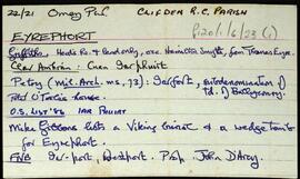
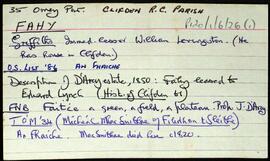
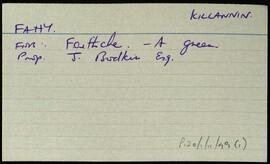
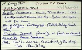
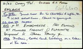
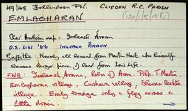
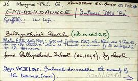
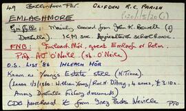
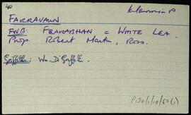
Index card relating to the townland of Eighterard, [íochtar Ard].
Robinson,TimConnemara
559 Archival description results for Connemara
Set of index cards giving a description of the townland of Emlagh, [Imleach]. Included are descriptions of Sellerna Church, the rectory of which was demolished, and its outhouses converted into the house now called 'The Old Rectory'. The headstone of a sailor in the British Navy is to be found here. Some information on the church's last minister. Also described are Sellerna School, Sellerna Bay where a wedge grave known as Leaba Dermot can be found, and the children's burial ground also found by the bay.
Robinson,TimSet of index cards describing some of the local features of the townland of Emlagharan, [Imleach Árann]. Included are descriptions of Cois Abhann, and Trá Mhór Imleach Árann. Jim O'Malley, and an un-identified local person are credited with providing some of the information, as well as other sources such as Field Name Books, Griffith's Valuation, and details from the sale of the Martin Estate in 1849.
Robinson,Tim,O'Malley,JimSet of index cards describing some of the local features of Emlaghdauroe [Imleach Dhá Rú]. Some notes on the translation of the placename as the swamp of the two red cows. Descriptions of the Roman Catholic chapel (formerly a Protestant Church), Binn Gleann Uisce, Emlaghmore, Loch an Easáin, Emlaghmore Lake, Knocknacalliagh Lough, Cross, and Conga Lough. Local sources of information are Martin King of Bar na Varán, Martin Halloran, John Joyce, and Paddy Linnane of Roundstone.
Robinson,Tim,King,Martin,Halloran,Joyce,John,Linnane,PaddySet of index cards describing some of the local features of the townland of Emlaghmore, [Imleach Mór]. Included are descriptions of Roisín Travers, Loch Beithinis, Loch na Láibe, Loch an Uisce, Loch an Tortáin, Callow Bridge (blown up during the War of Independence to isolate Clifden), Emlaghkeeragh Lake, Imleach Mór, The New Cut, The Long House, Emlaghmore Lodge, Lough Barrcostello, a note from material held in UCD as part of the Folklore Commission material, Roisín a Scáilí, and Emlaghmore House. Michael Goulde, Mr. Tinney, and Bartley King of Callow are credited as being local sources of information.
Robinson,Tim,Goulde,Michael,King,BartleySet of index cards giving a description of the townland of Eyrephort, [Iarphoirt]. Included are descriptions of wedge tombs, na Sealachán, Calpach, Ardrow (a shore at the west end of the townland), and a Viking burial site on the north coast.
Robinson,TimSet of index cards giving a description of the townland of Fahy, [An Fhaiche]. Included are descriptions of Giorrán's, Fuach Thaidhg, Promontory Fort, and Cloch an tSaighdiúra. A Mr. Mullen and Mr. Grath are credited with providing some of the local information.
Robinson,TimSet of index cards giving a description of the townland of Fakeeragh, [Faiche Chaorach]. Included are descriptions of a very unusual long cist in a low cairn (Robinson has included an illustration), the Girl's School (established c. 1849), Caladh na gCaorach, and Glen Iren.
Robinson,Tim