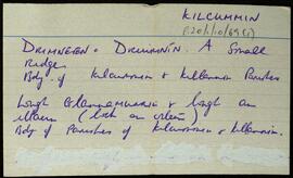
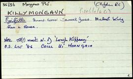
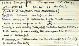
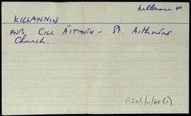
Set of index cards describing some of the local features of the townland of Killymongaun, [Coill Uí Mhongáin]. Included are descriptions of the rock at Killymongaun, a grave which is rumoured locally to be that of "the man the curate shot" (reference to An tAth Maoilre at Doire Bhrón, who shot a spy who tracked him down). Also described are Lough Kippaun, a Ringfort, Doire Bhrón, Waterloo Bridge, Curragh More, Clisham's Cliff, and Loch a Phéacháin. A letter from Paul Mohr in 1990, Rory Lavelle, and Ritchie Savage are credited with providing some of the local information.
Robinson,Tim,Mohr,Paul,Lavelle,Rory,Savage,Ritchie
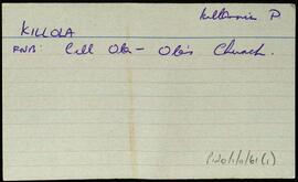
Connemara
559 Archival description results for Connemara
Overview list of the following townlands within the Roman Catholic Parish of Killeen [An Cillín]. Robinson describes this as "The peninsula of An Cheathrú Rua, with Doire an Fhiach and Leitir Mucú, and Garomna and Leitir Mealláin islands). Cards include an Irish and English language rendition of each of the placenames. The following townlands are included.An Cheathrú Rua Theas [Carrowroe South], An Cheathrú Rua Thiar [Carrowroe West], An Cheathrú Rua Thuaidh [Carrowroe North], Leitir Mucú [Lettermuckoo], Barr an Doire [Barraderry], An Caorán Beag [Keeraunbeg], Cladhnach [Clynagh], An Cnoc [Knock], Caolach [Creelogh], Doire an Fhéich [Derrynea], (with a note on the back mentioning Loch Uí Chadhain), Garomna [Gorumna Island], An Máimín [Maumeen] incldes a list of local lakes and points, and Tír an Fhia [Teernee].
Robinson,TimSet of index cards describing the physical features of Killeen, part of Ballynahinsa Demesne. Located in Moyrus Civil Parish, and the Roman Catholic Parish of Roundstone.
Tim Robinson,Tom Joyce, Annie Joyce, Kevin Joyce, Martin O'Malley,Joe MannionOverview list of the following townlands within the Civil Parish of Killannin. The cards include the Irish and English language renditions of the townland names.Oileán Iarthach [Illauneeragh], Leitir Móir [Lettermore], Leitir Calaidh [Lettercallow], Inis Bearchain [Inishbarra], Eanach Mheáin [Annaghvaan], and Béal an Daingin [Bealadangan].
Robinson,TimIndex card for the townland of Killaguile, [Cill an Ghaill].
Robinson,TimSet of index cards describing some of the local features of the townland of Kill [An Chill]. Included is information from the Congested Districts Board, and the Estate of Alex Thompson. A line from the returns in Griffith's Valuation is also included. Included are descriptions of Cill Fhlannáin, Carraig an Iasc, Loch na hAille Gairbhe, Cnoc na Cille, The Manor, Tobar Fhlannáin, and Loch na Cille. M. King is one of the local people credited with providing information.
Robinson,Tim,King,M.Index card giving a description of the townland of Kill, [An Chill]. Included are descriptions of Ross (the eastern half of the townland), Kill Bank, Oileán na Mionán, the national school, Standing Stone, and a detailed note on the local chapel. Included here is a description of unusual grave slabs of concrete decorated with shells. An anecdote involving pirates and an unfortunate local man.
Robinson,TimSet of index cards relating to the civil parish of Kilcummin. Mostly these are notes from the Small Names Index. It mentions specific features of the parish: Druimnín, Loughacloghar, Lough salach a chlochain, Derrygowna Road, Crumlin Bridge, Moor Park, and Srathadán (an island in Lough Corrib).
Robinson,Tim