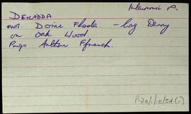
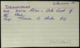
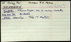
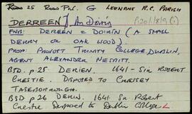
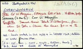
Set of index cards describing some of the local features of the townland of Currywongaun, [Corr Uí Mhongáin]. Included are descriptions of Cnocán Mór, Thornton's Hill, Fearsaí, The Plantation, and Marconi Station (three masts which lie on Currywongaun Hill).
Robinson,TimConnemara
559 Archival description results for Connemara
Set of index cards giving a description of the townland of Cushatrough, [Cois an tSrutha]. Included are descriptions of a mass rock, located in the front garden of a Mrs. Gough's house, Dún Bhigeáin, and an oyster farm. Local people Peter and Ann Molloy, and Tom and Philomena Welsh are credited with providing some of the local information.
Robinson,Tim,Molloy,Peter,Ann,Welsh,Tom,PhilomenaSet of index cards describing the physical features of Cushatrower [Cois Treabhair], for the most part a series of lakes and hills. Included in the descriptions are Croc an 'ow', Cara Móra, Crocán na Scraith, Seanbhantraí, Loch Scailp, Loch Chait, The White Lakes, and Loch Caimín. Paddy and Francie Linnane are credited as the sources of some of the information given.
Robinson,Tim,Linnane,Paddy,FrancieSet of index cards detailing some of the local features of the townland of Daighinis/Daimh Inis, [Dinish Island]. Only two households remain (the MacDonnchas and Loftus family), Several local features are described, including Na Seanbhallaí Dhaighnis, Crompán Sheanáit, Duirling an Chadáis, Bóthar na Naomh, na Binseacha, Muc Ghain Dhaighnise, Trá na Dumhaí Bige, Leic an tSoiligh, Bealach Dhaighnis, Scailp na Ceilpe, Carraig an Chlaímh, Leac na Scardáin, Cloch an tSeoil, Leac na bhFaoileán, An Duirling Mhór, Cora Dhubhail, Carraig an Duibhéin, Lochán na gCapall, An Trá Mhóir, Bruiser Rock, and Duirling an Eabhair. Tom Loftus and Tom Lee are credited as being local sources of information.
Robinson,Tim,Loftus,Tom,LeeSet of index cards describing some of the local features of the townland of Dawrosbeg [Damhros Beag]. Included are descriptions of Ballinakill Harbour Oysters, where 20-30 people were employed in the late 19th century. The West of Ireland Oyster and Fish company collapsted a few years later, and the oyster beds were worn out by 1903. Roisín, a peninsula called Rushyhaughtily on the OS, and a description tracing the ownership of the lobster ponds there. Lochán Lí (Liath), Lugán Driseach, Líonadh Mór, Oileán Buí, Scóchaí, Doilín Garbh, Oileán Lachan, Roeillaun (Roe Island), Lochán an tSáile, and Cnocán na Beirtrí are also described. Professor Noel Wilkins of UCG, Jim Joyce and his wife are all credited with providing some of the local information.
Robinson,Tim,Wilkins,Noel,Joyce,JimSet of index cards describing some of the local features of the townland of Dawrosmore [Damhros Mór]. Features described include Cnocán na Coille (where the mark of St. Ceannann's hand, clenched fist, and knee are to be found on its west side), the former Doctor's house (built c. 1895 and overlooking Bearna Dhearg Bay), Damhros (where oyster bays and pearl breeding mussels can be found), Dawros Bridge, Macalla, Ceapachaí, Carraig na Bearna, Bearna Dhearg, Carraig na bPlobóg (pollack), Cnoc an Iobra, the Hotel and Courthouse (originally Temperance Hotel, later Carson's, then O'Grady's), Oileán na nUan/Lamb's Island, Creggauns, and Steve's Lake. Local residents Joe Lydon, and Mr. and Mrs. Jim Joyce are credited with providing some of the local information.
Robinson,Tim,Lydon,Joe,Joyce,JimIndex card relating to the townland of Derralaura, [Doire Lára].
Robinson,TimSet of index cards describing some of the local features of the townland of Derreen. Included are descriptions of a Megalithic Tomb and nearby ringfort. A small doodle is also included. A note on the card indicates Tim visited this in 1989.
Robinson,Tim