Connemara

Elements area

Taxonomy

Code

Scope note(s)

    Source note(s)

      Display note(s)

        Hierarchical terms

        Connemara

          Equivalent terms

          Connemara

            Associated terms

            Connemara

              559 Archival description results for Connemara

              559 results directly related Exclude narrower terms
              Roisín an Bholgáin
              UGA P/P120/1/2/37/1 · Item
              Part of Personal

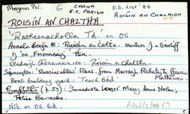
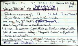
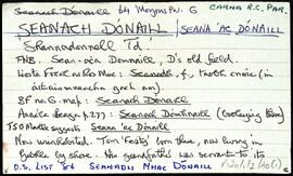
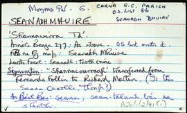
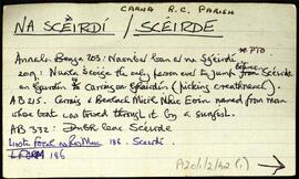
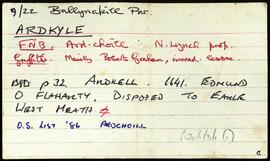
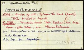
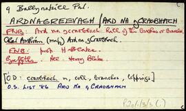
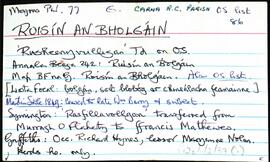
              Set of index cards describing the local features of the townland of Roisín an Bholgáin [Rusheenyvulligan]. Included in the descriptions are Loch na Lannach, Liacán, Carraig na nIasc, Carraig Théagair, Leacracha Clann Philipe, Barr na Stocaí, Carraig na gClochartach, Carraig an Spiocáin, Carraig Choilm, Carraig na hEirimiste, Carraig Pheadair, Carraig an tSrutha, and Na Clocha Móra. The word 'local' is written at the top of several of the index cards, indicating local sources provided Tim Robinson with some of the information.

              Untitled
              Roisín an Chaltha
              UGA P/P120/1/2/38/1 · Item
              Part of Personal

              Set of index cards describing the local features of the townland of Roisín an Chaltha [Roisín an Chalaidh on logainm.ie. English version is Rusheennacholla]. Included in the descriptions are Loch na Lannach, An Chora Rua, Roisín na gCapall, Lathach na bhFód, An Chara Mhóir, and Step na bPílears. Seán Ó'Ceoinín credited as having been a local source of information.

              Untitled
              Roisín na Mainiach
              UGA P/P120/1/2/39/1 · Item
              Part of Personal

              Set of index cards describing the local features of the townland of Roisín na Mainiach [Rusheennamanagh]. A list of references and a checklist giving further sources of information. Included in the descriptions are Droim na Loiche Duibhe, Carraig na bhFaoilleán, An Murlach, An Troscán, Bóthar Scainimh, Ballaí an Chliabháin, Crompán Mhaoilleáin, Aill an Ghlasoileáin, Oileán Uí Ghríofa (Griffin's Islands on the OS maps), Céibh Aill Eachrais, Na Coiléir, Tamhnachaí, An Muing, Clochar na Pluide, Ard Choilm Mhóir, Loch an Chriogáin, Bóithrín Fanach, An Draein Mhór, Crompán Dubh, Oileán na cGaróg, Abhainn na Scainimhe, Tobar Muire (includes some local stories about this well), Cnocán Hamilton (Hamilton of Carna Lodge. This hillock is where he used to read his papers), An tOileán Fada, Cnocán an Iorla, Oileán na bhFraochóg (a round island on Loch Sídúch), Loch Dubh, Cnocán Sheamuis, Bóthair Shídúch, An Cnocán Mór, Loch an Chaolla, An Criathrach Mór, Bóthar an Chlochairín Bháin, Locb na Lannach, Gairdín Major Gaskil/Forbes, Loch na Scainimhe (Lough Skannive on the OS maps), Loch Sídúch (Lough Sheedagh on the OS maps), An Chora Dhóite, Oileán an Bhalla, Bun an tSrutháin, Teach an Mhajoir (local stories that he gave the site for the convent), and Crompán na bPeelers (where local guards were drowned while fishing). Several local sources are credited with providing information. These are namedas Josie Gorham/Guairim, Seán Ó'Ceoinín, a Bourke from Troscán, Micheál McDonncha, and Eoin Ó'Néill.

              Untitled
              UGA P/P120/1/2/40/1 · Item
              Part of Personal

              Set of index cards describing the local features of the townland of Seanach Dónaill/Seana Mhac Dónaill [Shannadonnell]. Included in the descriptions are Loch an Phíobaire, Cnoc Seanach Dónaill (the hill with two peaks called Na Béacáin), Loch Bharr an Easa (Lough Appeebera on the OS maps), Loch Seanach Dónaill, Loch na nGleannta Móra (Maumeenmaunragh Lough on the OS maps), and Loch na gCloch. M Coyne credited as being a local source of information.

              Untitled
              Seanadh Mhuire
              UGA P/P120/1/2/41/1 · Item
              Part of Personal

              Set of index cards describing the local features of the townland of Seanadh Mhuire/Seana Bhuire on logainm.ie. [Shannawirra]. Included are descriptions of Loch an Bhroic Bhig, Tamhnach na mBairéadach, and Cnocán an Bhodaigh. M. Coyne credited as being a local source of information for this townland.

              Untitled
              Na Sceirdí / Scéirde
              UGA P/P120/1/2/42/1 · Item
              Part of Personal

              Set of index cards describing the local features of the townland of Na Sceirdí/Scéirde (possibly Skerdbeg]. Included in the descriptions are Leaba Sceirde, Na Scéirdí, Leathrach Mhóir Sceirde, Dún Ghudail, and Carraig an Mhíle. Noel King credited as being a local source of information.

              Untitled
              Ardkyle
              UGA P/P120/1/3/1/1 · Item
              Part of Personal

              Set of index cards describing some of the local features of the townland of Ardkyle, [Ardchoill]. Descriptions are given of Freaghillaun South (Freegh Island), Carraig Ghéar (Carrigeen South), Cuainin Garbh, Ross Beach, Poll na gColm (Ooeycolum on the OS maps), Glasoileán, Leac na mBó, Leac na Sronna, and Fruaigh Leathan. Some notes are included offering musings on the meanings of the different place names. Paddy Heanue of Letterbeg, and an old man who lives in the last cottage in Ardkyle are credited as providing some of the information therein. A note on a ruined megalith, 25 metres from a cliff ledge. A letter from Mike Gibbons (1988), is credited as being the source of some of the information.

              Untitled
              Addergoole
              UGA P/P120/1/3/2/1 · Item
              Part of Personal

              Set of index cards describing some of the local features of the townland of Addergoole, [Eadargúil]. Included are descriptions of the National Park lands, in which he traces the ownership of the land since after the Famine, during which time it was part of the Martin Estate, the property of the Barrow and Calcutta Jute Company, James P Joyce, and currently the property of the OPW. Kylemore Farmhouse and yard are also described, with some detail on Addergoole Farm in the 19th and 20th centuries (a model farm, in which bogland was reclaimed, and the site of a turbine which powered a local sawmill). Tullygwee Bridge (Tulaig Guide bridge over the Dawros River), Glencorbet, Meacanach (Muckanaght) are also described.

              Untitled
              UGA P/P120/1/3/3/1 · Item
              Part of Personal

              Set of index cards describing some of the local features of the townland of Ard na gCraobhach [Ardnagreevagh]. Included are descriptions of Freaghillaun North, Lúibín an aill, Cathair (a ringfort), a forge, Bóithín na Cathrach, Carraig Léith, Cuainín Mór, Carraig an Bhradáin, Portín na Lachan, Fó Mhainnín, Aice, Ceann na Dumhaí, Cnocán na Sceithí, and Port an Chaisleáin. Several references are given to 'Hidden Connemara' as a source of information for this townland.

              Untitled
              Attirowerty
              UGA P/P120/1/3/4/1 · Item
              Part of Personal

              Set of index cards describing some of the local features of the townland of Áit Tí Robhartaigh [Attirowerty]. The Field Name Books mention this is the site of the house of Roarty. Some notes about the ownership of the townland, dating back to the Martin estate, and a description of Traheen River.

              Untitled