Connacht

Elements area

Taxonomy

Code

Scope note(s)

    Source note(s)

      Display note(s)

        Hierarchical terms

        Connacht

          Equivalent terms

          Connacht

            Associated terms

            Connacht

              4 Archival description results for Connacht

              4 results directly related Exclude narrower terms
              Curragh
              UGA P/P120/1/3/19/1 · Item
              Part of Personal

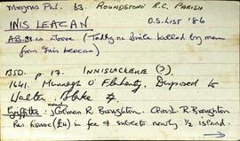
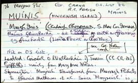
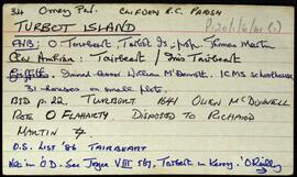
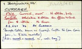
              Set of index cards describing some of the local features of the townland of Curragh [An Currach]. Included are descriptions of Carraig na gCapall, Soul Island, Carraig na bPortán, Inishbroon, Renvyle Point, Bearna Bhuí, Carraig Ghéar, Carraig an Choismeig, An Fó Mhór, Fó Toby, Fóin Fada, Carraig an Ealtóg, Carraig Ramhar, Carraig Ard, Bearna na Gaoithe, Lochán Mór, Aill Mhór, Carraigíní, Carraig an Róist, Fó Mhurchí, Cuainín Bán, Cnocán na Ceilpe, Duirling ó Dheas, Cuainín Labhrais, Leac an tSleabhcáin, Carraig na nGasúr (used to be known as Carraig an Fhómhair, but was renamed after the drowning of six young boys fishing for pollack), An Leac Buí, Idir Dhá Mhaoil, Fó na Fola, Duirling ó Thuaidh, Maol Mór and Maol Beag, Cuanín an tSimléir, Three rocks (named An Lao, An Bhó, and An Tarbh), An Fóin, Carraig an Altóir, Aic an Altóir, Carraig an Bhallaigh Mhóir, An Fóin Fada, Taobh ó Thuaidh, Carraig Uí Garéadáin, Fó Glais, Fó na Rísigh, Béal Gearr, Cathair an Dúin, Cnoc na Síog, The Blake's Farm, and Stáid. Some of the information gathered for this placename was derived from Paddy Heanue of Letterbeg, the CW map, and Paddy Fitzpatrick.

              Robinson,Tim,Heanue,Paddy,Fitzpatrick
              Inis Leacan
              UGA P/P120/1/1/34/1 · Item
              Part of Personal

              Set of index cards describing the local features of the townland of Inis Leacan [Inishlackan]. The ownership of the island is outlined from the 17th century, tracing its custodianship from the O'Flaherty clan, to the Blakes, the Broughton family from 1835, and Robert Macready of Ballinafad who bought it in 1900. Other sources of information consulted during this are listed as the 1st Report of the Fishery Commissioners, which came out in 1836, and Alex and John's log books, as well as a book entitled 'Three Men on an Island'. Some information on the Broughton family sourced in Griffith's Valuation is the subject of a couple of index cards. The features of Inis Leacan described here include Bodkin's House, some information about an account given by D'arcy Wentworth Thompson of a stay in Roundstone. Inis Leacan's school is also described, which closed in 1925 when the numbers fell below 25 pupils. The Mountain View Lodge, former home of the Broughton family, now a ruin is also described. Other physical features of the area that are described, are the Caorán, Duirling Mhór, The North Side of the island (as distinct from Trá Valley), Trá Valley (sometimes referred to as Trá an Bhaile), Carraig an Ghabhair, Fuaigh na Móna, Garraí Láir, Garraí Mór, Cnocán Mór, the Lighthouse Garden, Cnocán an tSagairt, Maoileann Garbh, Poll na Bantraí, Poll Bhairtleimíd, Poirín Beag, Poll na Cloiche, Trá na Feamainne, Cor na Cloiche, Raic Bay, Tóin an Oileáin, Trá Bheag, Aill na Brón, Poll na Stiúrach, Trá Roilligh, Barr na Leapa, Searrach Beag, Searrach Mór, Inis Leacan harbour, Poll Bréan, Inis Leacan beach, Cnocán an Ghréasaí, Cora Lín, Fuaigh Chaol, Carraig an Duilisc, Table Rock, Duirling na Glafaí, Carraig Íochtair, Céibh Mhaitiú, Carraig Báid Bán, Cloch Bhuí, Sceird, Lochán na mBallach, Garraí na Scraithe, Carraig na Ceilpe, Carraig an Iasc, Carraig na Leabhaí, Carraig na bPortán, Leachta Buí, Aill an Chipín, Carraig na gCon, Carraig na Beirtrí, and St. MacDara's well. Paddy McDonagh is a local source credited with providing information.

              Robinson,Tim,McDonagh,Paddy,Great Britain. Royal Commission of Inquiry into the State of Irish Fisheries,1836
              Muínis
              UGA P/P120/1/2/34/1 · Item
              Part of Personal

              Set of index cards describing the local features of the townland of Muínis [Maínis on logainm.ie, translated into English as Mweenish Island]. Note about ambiguity between Moyrish and Muínis in Simington's 'Books of Survey and Distribution'. Included are descriptions of Feithearnach, Carraig na Blaodhaí, a detailed note on the Estate of Colonel Nolan, sitting MP for North Galway. An Chreig Mhóir, An Sián, a causeway, Trá na mBád, An Cuainín, Muc Ghainimh, Maidhm Mhairtín Thaidhg, Crompán an Chúir, Stupóg an Táilliúrn, Leathrach na mBran (a fishing spot), Leaba Dhiarmaid, Bhéard na gCathasach. An Cuan Mór, Poll an Chora, Aill Chaltha an Aifrinn, Aircín an Mhaide Rámhair, Rinn Bheiglach, Ardskillan, Cibh an Bhéartha, Trá na Dumhaí Bige, Trá Fhada, Leic an Mhuinigh, An Ard-Thrá, Maidhin Mhicil Bhuí, An Garraí Mór, Mweenish Lodge, Carraig an Gharraí Aird, Oileán Lachan (Duck Island on the OS maps), An Dumhach Fhionn, An Aircín Thoir, An tSáilín, Oileán an Chara, Aircín Thiar, Crompán an Liamháin, Tóin Roisín, Trá an Bhoilg, Trá Dheiscirt, An Trá Mhóir, Tobar Cholm Cille, Mac Con Iomaire, Tobar na Seacht nIníon (well of the seven daughters on the OS maps), Loch Varáin, Carraig na mBan, Inis tSruthair, Tonn Uí Floinn, Tóin Ghairbh, An Meall Rua, Cartúr, Portach Mhuínse, Carraig na bPortán, Tobar Cholm Cille, Garraí na nGéabha, Leic na Gharraí Ghainimh, Bóithrí na Trá, Na Corainneacha, Leic na Cora, Coréal Mheaircín, and Clochar an Mhadra Uisce. The word 'local' is written on several of the index cards, indicating that Tim Robinson would have spoken with members of the community, and taken their knowledge of places and spellings in compiling this information. Two individuals are named, Sgt. P O Conaola, and M King of Inis Ní. Several other sources are credited, including Brother Conal Thomas's book 'The Land for the People: The United Irish League and Land Reform in North Galway, 1898-1912', Liosta Focal, Chroí Chonamra, and Nimmo's 1825 map.

              Robinson,Tim,Conaola,P. O.,Sgt.,King,M.
              Turbot Island
              UGA P/P120/1/6/61/1 · Item
              Part of Personal

              Set of index cards giving a brief description of Turbot Island, [Tairbeart]. A note on the last inhabitants of Turbot Island, around 50 or so people who left the island in winter 1978/79 after a particularly tough winter when 3 men drowned. A note on when the island first got electricity. Also included are descriptions of Caladh Mór, Carraig an Duibhéin, Maoileán an Mhadra, Maoileán na nÉan, Carraig Leathan, Fuach Black, Carraig a Graiflin, Cuainín, Bantrach Bhuí, Réileán, Cairín, Poll Trá, Dúilic, Tóin an Oileáin, Cois, Carraig na bPortán, Carraig Gheagáin, Lochtaí, Lochán na Móna, Leic, Carraig na Rón, and Úbhra Mhór and Úbhra Bheag. Festy Conneely (once an islander), John Price of Eyrephort, and the un-named residents of the nearest house are credited with providing some of the local information.

              Robinson,Tim