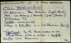
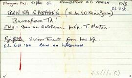
Set of index cards describing the physical features, many of which are small islands, of Bun na hAbhann, [Bunnahown]. Descriptions are given of Oileán na gCaorach, Cora Sheáinín Mainnín (a northern point on the inlet), Tobar Muire, na Cairrgí Dubha, Barr na dTamhnach, Loch an Phoill Mhór, Corn Island, Loch an Tairbh Dhuibh, Oileán Aodha, Oileán Chamaill, Glasoileán Mór, Oileán Donn/Domhain, Oileán Gorm, Caladh Cam, Cruachnait (Croghnut on the OS maps), Rua-oileán, Leacht na bhfaoileán, and The Wire (a long natural causeway of rocks). Tim Robinson cites local sources as having helped wtih much of the information gathering, with particular mention of M. Clogherty, Anthony Ridge of Bun na hAbhann, Máirtín Ó'Catháin of Gabhla, Patrick King's son, and MacDara Green.
Robinson,Tim,Clogherty,M.,Ridge,Anthony,Ó'Catháin,Máirtín,Green,MacDaraConnacht
2 Archival description results for Connacht
Set of index cards describing some of the local features of Cill Bhreacáin, [Kilbrickan]. A note about Leic Bhriocáin which was located near the well, and which people used to swear on during disputes. Also included are descriptions of Droim a Báire, Cnocán na gCábán, Céibh an Chultána, An tOileán Iarthach, An Cró, Carraig Mhór, Cora na Dumhaí, an tSruthair Mhór/Bheag, An t-Oileán Mór, Caladh an Uisce, Caladh na Sceiche, Céibh an tSiléir, Cora na nGabhar, Carraig an Fhuaráin. Clochar an Mhadar Uisce, Céibh an tSrutháin Bhuí, Caladh Chill Bhriocáin, Rua-oileán, Aill Bhuí, Cuan an tSrutháin Bhuí, An t-Oileán Mór, Oileán na gCapall, Cuan na hAille Buí, Céibh Nua, Céibh Ceann an Bhothair, Aill na Ceilpe, Áth na mBeithioch, and Aill na Móna. Colm O'Gaora, T. O'Conaire of Gort Mór, and M. O'Niaidh are credited as being local sources of information.
Robinson,Tim,O'Gaora,Colm,O'Conaire,T.,O'Niaidh,M.