Connacht
558 Archival description results for Connacht
558 results directly related
Exclude narrower terms
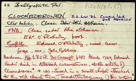
UGA P/P120/1/3/11/1
·
Item
Part of Personal
Set of index cards describing some of the local features of the townland of Cloonederowen [Cluain Idir Dhá Abhainn]. A note about the distressed circumstances of Edward Láidir who died at this estate in 1749. The extraordinary size of his bones make them an object of wonder. A description of a stone row is also given, received from Mike Gibbon,
Robinson,Tim,Gibbon,Mike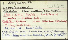
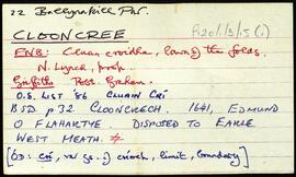
UGA P/P120/1/3/16/1
·
Item
Part of Personal
Set of index cards describing some of the local features of the townland of Cloonlooaun [Cluain Luáin]. Included are descriptions of Fraochoileán, Gleanntán, Scoil Náisiúnta Naomh Bríd (St. Brigid's National School, formerly known as Eagle's Nest School on the Ordnance Survey maps). A stone alignment, the Mission School, Doire Loch, Loch Tí Finn (Loughaun on the OS maps), a Portal Tomb, Cairns, Lorga, Dóilín and Carraig an Dóilín, Gob an Chorráin, Maola Eoin Jack, Poll Cloch, Ruddy's Rocks, Carraig Máire Stíofáin, Garraí Ghainimh, and Lochán an Charraigín are all included in the descriptions. A letter from Mike Gibbons, and local knowledge are credited with providing some of the information.
Robinson,Tim,Gibbons,Mike
UGA P/P120/1/1/18/1
·
Item
Part of Personal
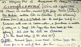
Set of index cards describing the physical and historical features of Cloonnacartan [Cúil na Ceártan], as well as related anecdotes. The features described are Doire na nGabhar, Doire na Raithíní, Gurán, the Derryclare Marble Quarry, Cora Lú, Cora Mhór, Cora Láir, Béalógaí, Gabhlán, the Inagh Valley Inn, Loch na Tulaí Bige, and Hazel Lodge. Sources credited with providing information are Dela McAuley, PJ O'Loghlen, and Ambrose Joyce of the Connemara Marble Factory.
Robinson,Tim,McAuley,Dela,O'Loghlen,PJ,Joyce,Ambrose
UGA P/P120/1/10/43/1
·
Item
Part of Personal
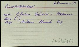
An index card relating to the townland of Clooshgereen, [Cluais Chéirín].
Robinson,Tim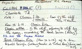
UGA P/P120/1/1/15/1
·
Item
Part of Personal
Set of index cards describing the physical features of Cluain Aidhle [Cloonisle]. Descriptions given are of Gort Triomach, Cnocán na Ceártan, Garaí Mhary, Graves, Loch Shéamuisín Niaidh, The Buacáns, the Giant's Grave, the Green Gardens, Cnoc na Seitle, Lathach na Chaoráin, and Cnocán na gCorpr. Sources of information credited are a local person named Riley, Annie Conneely, and P. and A. Conneely.
Robinson,Tim,Conneely,Annie,Peter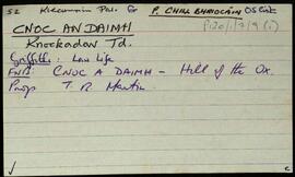
UGA P/P120/1/7/9/1
·
Item
Part of Personal
Set of index cards describing some of the local features of Cnoc an Daimh, [Knockadav]. Robinson offers a translation of Hill of the Ox, derived from the Ordnance Survey Field Name Books. Included are descriptions of Loch na hEasléime, Tmnach Lug na gCléireach, the Old Road to Derrough North, Tobar Beannaithe, Cara Throiscín, An Leacht/Leachta Labhráis, An Tall Darach, a note on the Salmon Hatchery (one of the earliest in Ireland), Loch Bhallaí Mhongáin, Loichín Nora Ní Niaidh, Seana Mhac Conraoí, Loichín Bharr an Éadain, Loch an Fhraoigh, Aill an Chliabhraigh, Barr na dTamhnachaí Bána, Criogán na Seithe, An Draem Bhoiste, Binn Ard Loch an Daimh, Log na gCleireach, and Garraí Ruaidí. Paddy Folan of Scríb, and Paddy Joyce of Úraid are credited as being local sources of information.
Robinson,Tim,Folan,Paddy,Joyce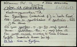
UGA P/P120/1/7/10/1
·
Item
Part of Personal
Set of index cards describing some of the local features of Cnoc na Gairfine [Knocknagarrivhan]. Included are descriptions of Loch na Gairfine, Loch na bhFreangach, Loch an Damba, and Loch na hAille. Peter Flaherty, and Mr. Walsh of Muic na Coille are credited with providing some of the local information.
Robinson,Tim,Flaherty,Peter