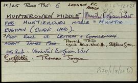
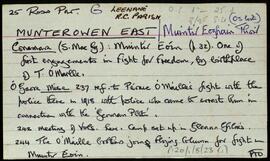
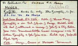
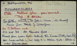
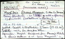
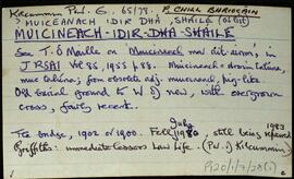
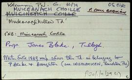
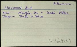
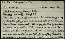
Connacht

Elements area

Taxonomy

Code

Scope note(s)

    Source note(s)

      Display note(s)

        Hierarchical terms

        Connacht

          Equivalent terms

          Connacht

            Associated terms

            Connacht

              558 Archival description results for Connacht

              558 results directly related Exclude narrower terms
              Clooncree
              UGA P/P120/1/3/15/1 · Item
              Part of Personal

              Set of index cards describing some of the local features of the townland of Clooncree, [Cluain Crí]. St. Canannagh's well and a megalithic tomb are included in the description.

              Untitled
              Cloonlooaun
              UGA P/P120/1/3/16/1 · Item
              Part of Personal

              Set of index cards describing some of the local features of the townland of Cloonlooaun [Cluain Luáin]. Included are descriptions of Fraochoileán, Gleanntán, Scoil Náisiúnta Naomh Bríd (St. Brigid's National School, formerly known as Eagle's Nest School on the Ordnance Survey maps). A stone alignment, the Mission School, Doire Loch, Loch Tí Finn (Loughaun on the OS maps), a Portal Tomb, Cairns, Lorga, Dóilín and Carraig an Dóilín, Gob an Chorráin, Maola Eoin Jack, Poll Cloch, Ruddy's Rocks, Carraig Máire Stíofáin, Garraí Ghainimh, and Lochán an Charraigín are all included in the descriptions. A letter from Mike Gibbons, and local knowledge are credited with providing some of the information.

              Untitled
              Crump Island
              UGA P/P120/1/3/17/1 · Item
              Part of Personal

              Set of index cards describing some of the local features of the townland of Crump Island [Oileán Dá Chruinne]. Background information and lore from various other sources is summarised on these cards, including a note about Blake of Renvyle and his boat on a visit to Oileán Dá Chruinne (Isle of the Shrine). An oratory and a romantic cemetary are to be found there, with headstones scuptured with crosses. A belief exists that any body interred here will be cast ashore. A letter written to Tim is also included here, with further information about Crump Island (known as Cramp by the resident).

              Untitled
              Culfin
              UGA P/P120/1/3/18/1 · Item
              Part of Personal

              Set of index cards describing some of the local features of the townland of Culfin [Cúil Finn]. Included are description of Carraig an Bolg (Carrickabullog Rocks on the OS map), Leac Ancaire, Carraig Leathan, a bed outshot on a derelict thatched cottage, and Cuilfinn River

              Untitled
              Curragh
              UGA P/P120/1/3/19/1 · Item
              Part of Personal

              Set of index cards describing some of the local features of the townland of Curragh [An Currach]. Included are descriptions of Carraig na gCapall, Soul Island, Carraig na bPortán, Inishbroon, Renvyle Point, Bearna Bhuí, Carraig Ghéar, Carraig an Choismeig, An Fó Mhór, Fó Toby, Fóin Fada, Carraig an Ealtóg, Carraig Ramhar, Carraig Ard, Bearna na Gaoithe, Lochán Mór, Aill Mhór, Carraigíní, Carraig an Róist, Fó Mhurchí, Cuainín Bán, Cnocán na Ceilpe, Duirling ó Dheas, Cuainín Labhrais, Leac an tSleabhcáin, Carraig na nGasúr (used to be known as Carraig an Fhómhair, but was renamed after the drowning of six young boys fishing for pollack), An Leac Buí, Idir Dhá Mhaoil, Fó na Fola, Duirling ó Thuaidh, Maol Mór and Maol Beag, Cuanín an tSimléir, Three rocks (named An Lao, An Bhó, and An Tarbh), An Fóin, Carraig an Altóir, Aic an Altóir, Carraig an Bhallaigh Mhóir, An Fóin Fada, Taobh ó Thuaidh, Carraig Uí Garéadáin, Fó Glais, Fó na Rísigh, Béal Gearr, Cathair an Dúin, Cnoc na Síog, The Blake's Farm, and Stáid. Some of the information gathered for this placename was derived from Paddy Heanue of Letterbeg, the CW map, and Paddy Fitzpatrick.

              Untitled
              Currywongaun
              UGA P/P120/1/3/20/1 · Item
              Part of Personal

              Set of index cards describing some of the local features of the townland of Currywongaun, [Corr Uí Mhongáin]. Included are descriptions of Cnocán Mór, Thornton's Hill, Fearsaí, The Plantation, and Marconi Station (three masts which lie on Currywongaun Hill).

              Untitled
              Dawrosmore
              UGA P/P120/1/3/21/1 · Item
              Part of Personal

              Set of index cards describing some of the local features of the townland of Dawrosmore [Damhros Mór]. Features described include Cnocán na Coille (where the mark of St. Ceannann's hand, clenched fist, and knee are to be found on its west side), the former Doctor's house (built c. 1895 and overlooking Bearna Dhearg Bay), Damhros (where oyster bays and pearl breeding mussels can be found), Dawros Bridge, Macalla, Ceapachaí, Carraig na Bearna, Bearna Dhearg, Carraig na bPlobóg (pollack), Cnoc an Iobra, the Hotel and Courthouse (originally Temperance Hotel, later Carson's, then O'Grady's), Oileán na nUan/Lamb's Island, Creggauns, and Steve's Lake. Local residents Joe Lydon, and Mr. and Mrs. Jim Joyce are credited with providing some of the local information.

              Untitled
              Dawrosbeg
              UGA P/P120/1/3/22/1 · Item
              Part of Personal

              Set of index cards describing some of the local features of the townland of Dawrosbeg [Damhros Beag]. Included are descriptions of Ballinakill Harbour Oysters, where 20-30 people were employed in the late 19th century. The West of Ireland Oyster and Fish company collapsted a few years later, and the oyster beds were worn out by 1903. Roisín, a peninsula called Rushyhaughtily on the OS, and a description tracing the ownership of the lobster ponds there. Lochán Lí (Liath), Lugán Driseach, Líonadh Mór, Oileán Buí, Scóchaí, Doilín Garbh, Oileán Lachan, Roeillaun (Roe Island), Lochán an tSáile, and Cnocán na Beirtrí are also described. Professor Noel Wilkins of UCG, Jim Joyce and his wife are all credited with providing some of the local information.

              Untitled
              Derryinver
              UGA P/P120/1/3/23/1 · Item
              Part of Personal

              Set of index cards describing some of the local features of the townland of Derryinver, [Doire Inbhir]. Included are descriptons of Fuaigh na gCaorach (Toirannageeragh on the OS), The Tulach, the Cist, Ardach, Crocán Stiofáin, Carraig Dhubh, Finn MacCumhail's Fingers (six standing stones), Doon/Doongill (site of a small ring fort), and Cluain Lárach. Local woman Mrs McDonagh, Michael Gannon, Mike Gibbons, and Patrick Nee are credited with providing information.

              Untitled
              Derryherbert
              UGA P/P120/1/3/24/1 · Item
              Part of Personal

              Set of index cards describing some of the local features of the townland of Derryherbert [Doire Thoirbirt]. Included are descriptions of Lug a' Mhada and Tully Hill.

              Untitled