Children's Burial Ground

Elements area

Taxonomy

Code

Scope note(s)

    Source note(s)

      Display note(s)

        Hierarchical terms

        Children's Burial Ground

          Equivalent terms

          Children's Burial Ground

            Associated terms

            Children's Burial Ground

              22 Archival description results for Children's Burial Ground

              22 results directly related Exclude narrower terms
              Fountainhill or Knockavilra
              UGA P/P120/1/6/28/1 · Item
              Part of Personal

              Set of index cards giving a description of the townland of Fountainhill or Knockavilra, [Cnoc an Bhiolra]. Robinson notes that Cnoc an Bhiolra can be translated as watergrass hill, or hill of the watercress. Included are descriptions of an Infant's Burial Ground, and Leaba Feichín, said to be where St. Feichín stopped before crossing to Omey.

              Robinson,Tim
              Glencraff
              UGA P/P120/1/3/32/1 · Item
              Part of Personal

              Set of index cards describing some of the local features of the townland of Glencraff, [Gleann Creamha]. Included are descriptions of Aill an Ghabhair, Gabhlóg Struthán Mór, Clochán na Bean Sí, Sruthán Mór, Anacair, Children's Burial Ground, Lug na Coille, Eas Dubh, Doirín, Lug an Fhia, Ceannáin Bhán, Cloch an Domhnaigh, Búcán, Cnocán an Iolra, Aill an Iolra, The Glen River, Pulófra, Megalithic Tombs, the Holy Well (which is locally associated with a St. Craff), Cloichín, and Easca Riabhach. Michael O'Néill and Chris O'Néill are credited with providing the information.

              Robinson,Tim,O'Neill,Michael,Chris
              Glengoaghan
              UGA P/P120/1/1/32/1 · Item
              Part of Personal

              Set of index cards describing the local features of the townland of Glencoaghan [Gleann Chóchan]. Features described include a lime kiln, Mám na bhFonsaí (recorded as Mám na Uinsí or rim in some places), Lotaí, Tinteánaí, Trinsí, Binn Dubh (Bencollaghduff on the OS map), The Planted Island, a Children's Burial Ground (a photo of which is included in 'Croí Chonamara'), Bengower, An Sindile (an arable area rich in quartz, and with a lime kiln), Mám Dearg (between Binn Dubh and Binn Bhán), Aill an Torainn, the mines (possibly sulphur), Binn Gabhair, Cnoc Trasna, Loch Cúl an Drama, Log an tSabha, Mám na Gaoithe, Mám an Lotaigh, and Fonsaí Ghaineamh. Local sources credited with providing information include local man Pat Joyce, Dela McAuley and Martin O'Malley, William O'Brien of Lotaí, Mrs Leonard of Ballinahinch Lodge, and John Hynes of Gleann Chóchan. (See also Teivebreen/Taobh Braoin for a brief description of Binn Briain, located between the two townlands).

              Robinson,Tim,Joyce,Pat,McAuley,Dela,O'Malley,Martin,O'Brien,William,Hynes,John
              Glinsce
              UGA P/P120/1/2/23/1 · Item
              Part of Personal

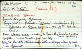
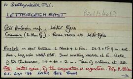
              Set of index cards describing some of the natural physical features of the townland of Glinsce [Glinsk]. Various sources are referenced giving insights into the origin of the placename, from Patrick Weston Joyce's 'The Origin and History of Irish Names of Places, Vol 3', which interprets it as the glen of the bramble bushes, to a local man who believes it derrives from 'gleann uisce'. Some notes are also provided on the modern day uses of buildings referenced in the OS maps, for instance the local school, Glinsk House, and Marble Studio. The physical features described are Loch an Roisín, Rusheen Point, Cnoc Glinsce, An Charraig Leith, Caladh Beag, An Caladh Mór, Corrán, a Children's Burial Ground, Loch Bhairtle, Barr an Linnín, Cnoc Bharr an Linnín, Abhainn Bharr an Linnín, Loch Cnocán na gCalapp, Caladh Thiobóid, Loch na Dubhaí (Lough Peastia on the OS maps, from the Irish word for worm, péist), Loichín Bharr an Chriathrach, Barr an Chlaí, Loch an Chaoráin, Céibh an Chaltha Mháire, Loch an Tamhnaigh, Tamhnachaí, Loch na Liathróide, Tulach na mBan, Loch an Mheill Mhóir, Tobar Mhuire, and Cuan na Beirtrí Buí. Information sourced from Bedford's map, Annála Beaga, and locally from Seán Ó'Ceoinín, Josie McDonncha, Frank Keaney and his grandmother, Josie Phádraig Cionnaigh, and Tomás Ó'Conghaile.

              Robinson,Tim,Ó'Ceoinín,Seán,McDonncha,Josie,Keaney,Frank,Cionnaigh,Josie Phádraig,Ó'Conghaile,Tomás
              Gowlaunlee
              UGA P/P120/1/8/12/1 · Item
              Part of Personal

              A set of index cards outlining some of the local features of the townland of Gowlaunlee, [Gabhlán na Lí]. Some summary notes from O'Donovan's name books, Griffith's Valuation, and the Placenames Department of the OS. Also included are summary descriptions of Birallate rath, Binn, Mám a Tuirc Móir, Gabhlain Ard, a note on the King Cottages (and Mr. King who was involved in the 1921 Munterowen ambush between the IRA and RIC), a note on Cillín (a children's burial ground), Anacair, Taobh Bán, Mám Ochóige, Mám Tuirc, and a detailed note on Pádraig Ó'Máille's cave (and a detailed sketch). The cave dates back to Spring 1918, and was used as a hideout by IRA leaders in the ensuing years.

              Robinson,Tim
              Lettergesh East
              UGA P/P120/1/3/40/1 · Item
              Part of Personal

              Set of index cards describing some of the local features of the townland of Lettergesh East, [Leitir Geis Thoir]. Included are descriptions of Góra Mór, Binn Chuanna, Scailp na Caillí, Sruthán na Gains, Idir Aill, Barr na Cloiche Duibhe, Caher, Cluain, Poll an Ghaoith, Children's Burial Ground, Carraig an Tiompáin, Acha na nGabhar, Maolchnoc, and Lug na nEach. Credited with providing information are Jenny Conboy, Martin Welsh, and a Coyne from Seanaveag.

              Robinson,Tim,Conboy,Jenny,Welsh,Martin
              Maum West
              UGA P/P120/1/8/19/1 · Item
              Part of Personal

              A set of index cards outlining some of the local features of the townland of Maum West [An Mám Thiar]. Included are descriptions of Mícheál Breathnach's House (a seanchaí, visited by Delargy and Seán Mac Giollarnáth), Cúilín (a burial place for children), and a note about an open cast mine. Michael Kyne is credited as being a local source of information.

              Robinson,Tim,Kyne,Michael
              Moorneen
              UGA P/P120/1/6/47/1 · Item
              Part of Personal

              Set of index cards giving a brief description of the townland of Moorneen [Muirnín]. Included are descriptions of a megalith (a two chambered tomb, and a small accompanying sketch), the children's burial ground, the former coastguard station, and a note on Sellerna Bay.

              Robinson,Tim
              Na Mine
              UGA P/P120/1/10/14/1 · Item
              Part of Personal

              A large series of index cards describing some of the local features of the townland of Na Mine, [Minna]. At the time of Griffith's Valuation, the lessor was Patrick Blake. Included in the descriptions are Aerfort Chonamara, a note on Thomas Lynch who was the proprietor in 1641, and a detailed note on the castle, where Walter Fada Bourke was murdered on the will of his step-mother, an O'Flaherty, to secure the inheritance of Risdeard an Iarain (Iron Dick) in the 16th century. And a note on Cora an Chasleáin, and a children's burial ground.

              Robinson,Tim