Tóin an Oileáin

Elements area

Taxonomy

Code

Scope note(s)

    Source note(s)

      Display note(s)

        Hierarchical terms

        Tóin an Oileáin

          Equivalent terms

          Tóin an Oileáin

            Associated terms

            Tóin an Oileáin

              4 Archival description results for Tóin an Oileáin

              Fínis
              UGA P/P120/1/2/19/1 · Item
              Part of Personal

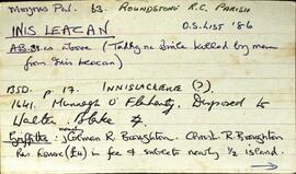
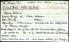
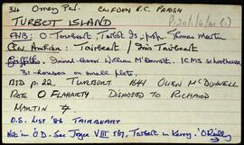
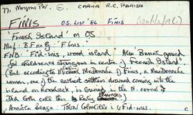
              Set of index cards describing some of the features of the townland of Fínis [Finish Island]. Some information from the Field Name Books, and derived from local lore about there being a burial ground for children and strangers in the centre of the island. Included in the descriptions are Trá Theach na Scoile, Tóin an Oileáin, An Gearrán, Carraig Bháird, Mullán an Róin, Trá na Leaca, Na hAnlacain, Béal na Trá, An Trá Mhóir, Trá na Muice, Trá an Uisce, Trá Bhun an Chlaí, Trá Dhubháinín, An Mhuic Ghainimh, Carraig Sheáin Uí Fheinne, Carraig Chrochúif, Carraig Éamainn, An Mhuc Ghainimh (referred to as 'Feenish Spit' on an Admiralty Chart), An Leachta, Carraig an tSeoigigh (Joyce's rock), Cora Phádraic Con Rí, Trá Thulach Thirin, An Clo' Bhuaile, Trá Bheag, Céibh an Chalaidh Mhóir, Trá na bhFataí Biata, Bóthar na Scoláire, Trá na Mumhan (a possible reference to settlers from Co. Clare), Leacracha Mhuintir Churraidhin (named after three Cill Chiaráin men who drowned), Poll na Sean-toinne, and Tobar Cholm Cille (an anecdote from Coilín MacDonncha included here, in Irish). Some local people credited with provding information, these are named as Coilín MacDonncha, S Ó'Ceoinín, P de Búrca, and E. Ó'Néill.

              Robinson,Tim,MacDonncha,Coilín,Ó'Ceoinín,S.,Búrca,P. de,Ó'Néill,E.
              Inis Leacan
              UGA P/P120/1/1/34/1 · Item
              Part of Personal

              Set of index cards describing the local features of the townland of Inis Leacan [Inishlackan]. The ownership of the island is outlined from the 17th century, tracing its custodianship from the O'Flaherty clan, to the Blakes, the Broughton family from 1835, and Robert Macready of Ballinafad who bought it in 1900. Other sources of information consulted during this are listed as the 1st Report of the Fishery Commissioners, which came out in 1836, and Alex and John's log books, as well as a book entitled 'Three Men on an Island'. Some information on the Broughton family sourced in Griffith's Valuation is the subject of a couple of index cards. The features of Inis Leacan described here include Bodkin's House, some information about an account given by D'arcy Wentworth Thompson of a stay in Roundstone. Inis Leacan's school is also described, which closed in 1925 when the numbers fell below 25 pupils. The Mountain View Lodge, former home of the Broughton family, now a ruin is also described. Other physical features of the area that are described, are the Caorán, Duirling Mhór, The North Side of the island (as distinct from Trá Valley), Trá Valley (sometimes referred to as Trá an Bhaile), Carraig an Ghabhair, Fuaigh na Móna, Garraí Láir, Garraí Mór, Cnocán Mór, the Lighthouse Garden, Cnocán an tSagairt, Maoileann Garbh, Poll na Bantraí, Poll Bhairtleimíd, Poirín Beag, Poll na Cloiche, Trá na Feamainne, Cor na Cloiche, Raic Bay, Tóin an Oileáin, Trá Bheag, Aill na Brón, Poll na Stiúrach, Trá Roilligh, Barr na Leapa, Searrach Beag, Searrach Mór, Inis Leacan harbour, Poll Bréan, Inis Leacan beach, Cnocán an Ghréasaí, Cora Lín, Fuaigh Chaol, Carraig an Duilisc, Table Rock, Duirling na Glafaí, Carraig Íochtair, Céibh Mhaitiú, Carraig Báid Bán, Cloch Bhuí, Sceird, Lochán na mBallach, Garraí na Scraithe, Carraig na Ceilpe, Carraig an Iasc, Carraig na Leabhaí, Carraig na bPortán, Leachta Buí, Aill an Chipín, Carraig na gCon, Carraig na Beirtrí, and St. MacDara's well. Paddy McDonagh is a local source credited with providing information.

              Robinson,Tim,McDonagh,Paddy,Great Britain. Royal Commission of Inquiry into the State of Irish Fisheries,1836
              Oileán Máisean
              UGA P/P120/1/2/35/1 · Item
              Part of Personal

              Set of index cards describing the local features of the townland of Oileán Máisean [Mason Island]. Included in the descriptions are Mulán na Srathrach/An tSrathair [Straddle Rock on the OS maps], Bealach na Srathrach, Trá an Éadain, Trá Bheirtreach, Carraigh Dháimhiú, Tóin an Oileáin, Guaire na gCrámha, Aill na Croise, Garbhcharraig (Rough Rock on the OS maps), Carraig an Ghun (Gun Rock), Oileán Aimhréidh (Avery Island), Garraí na Cilleach (marked as a burial ground on the OS maps), Lochán an tSeanduine, Carraig an tSnámha, Loch na dTaibhsí, An tAircín, Béal an Tairsí, and Oileán an Chortha. Some local individuals are credited with providing some of the information given for this townland, namely Joe Casey, an O Cathasaigh (noted as Joe Casey's son), and Brian Skinner.

              Robinson,Tim,Casey,Joe,Cathasaigh,O.,Skinner,Brian
              Turbot Island
              UGA P/P120/1/6/61/1 · Item
              Part of Personal

              Set of index cards giving a brief description of Turbot Island, [Tairbeart]. A note on the last inhabitants of Turbot Island, around 50 or so people who left the island in winter 1978/79 after a particularly tough winter when 3 men drowned. A note on when the island first got electricity. Also included are descriptions of Caladh Mór, Carraig an Duibhéin, Maoileán an Mhadra, Maoileán na nÉan, Carraig Leathan, Fuach Black, Carraig a Graiflin, Cuainín, Bantrach Bhuí, Réileán, Cairín, Poll Trá, Dúilic, Tóin an Oileáin, Cois, Carraig na bPortán, Carraig Gheagáin, Lochtaí, Lochán na Móna, Leic, Carraig na Rón, and Úbhra Mhór and Úbhra Bheag. Festy Conneely (once an islander), John Price of Eyrephort, and the un-named residents of the nearest house are credited with providing some of the local information.

              Robinson,Tim