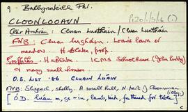
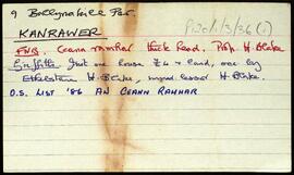
Set of index cards describing some of the local features of the townland of Kanrawer, [An Ceann Ramhar]. Included are descriptions of Tobar na Seacht nIníon, Rinn Mhil (a castle), Rinn Mhaoil, Poincéir, Leac an Phoincéir, Lorga, Dóchaoil, Leac an Phíaire, Lochán Céilia, Cuainín na Céibhe, Dall a'Gharbh, Fó an Asail, Cnainín Garbh, Port Láirge, Fó Mhairéid, and Fó Chaití.
Robinson,TimLorga
2 Archival description results for Lorga
2 results directly related
Exclude narrower terms
UGA P/P120/1/3/36/1
·
Item
Part of Personal
UGA P/P120/1/3/16/1
·
Item
Part of Personal
Set of index cards describing some of the local features of the townland of Cloonlooaun [Cluain Luáin]. Included are descriptions of Fraochoileán, Gleanntán, Scoil Náisiúnta Naomh Bríd (St. Brigid's National School, formerly known as Eagle's Nest School on the Ordnance Survey maps). A stone alignment, the Mission School, Doire Loch, Loch Tí Finn (Loughaun on the OS maps), a Portal Tomb, Cairns, Lorga, Dóilín and Carraig an Dóilín, Gob an Chorráin, Maola Eoin Jack, Poll Cloch, Ruddy's Rocks, Carraig Máire Stíofáin, Garraí Ghainimh, and Lochán an Charraigín are all included in the descriptions. A letter from Mike Gibbons, and local knowledge are credited with providing some of the information.
Robinson,Tim,Gibbons,Mike