Loch an tSáile

Elements area

Taxonomy

Code

Scope note(s)

    Source note(s)

      Display note(s)

        Hierarchical terms

        Loch an tSáile

          Equivalent terms

          Loch an tSáile

            Associated terms

            Loch an tSáile

              3 Archival description results for Loch an tSáile

              3 results directly related Exclude narrower terms
              Aughrus Beg
              UGA P/P120/1/6/5/1 · Item
              Part of Personal

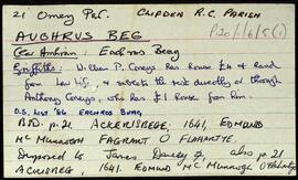
              Set of index cards describing some of the local features of the townland of Aughrus Beg, [Eachros Beag]. Included are descriptions of Oileán Chaorach, Foiriúnach Thiar, Codú (Cuddoo Rock), Caoile Mhór, Loch an tSáile, Gazebo (a hill), Poll Tolladh/Poll Tulach, and a brief note on the Coneys who leased the area. Local man Conor Laffy is credited with providing some of the information.

              Robinson,Tim,Laffy,Conor
              Doire Bhanbh
              UGA P/P120/1/7/13/1 · Item
              Part of Personal

              Set of index cards describing some of the local features of Doire Bhanbh, [Derravonniff]. A note on Screbe Estates Lodge, where Lord Dudley once lived, and Lady Dudley drowned here. A description of Scríb, with a note on Berridge of Screebe, formerly of Ballinahinch Castle. A note of an ambush at Scríb in 1921, when the Black and Tans were ambushed by Pádraig Ó'Máille's column, and later took revenge by burning 4 houses and a store. A note and illustration of the site of Screebe Lodge, which is not included in the 1839 map. There are two cards that detail the ownership of the Lodge from the time of the Berridges. Screebe Fishery, comprised of Inver and Screebe Salmon, and White Trout Fisheries is mentioned in the description. Summary cards are devoted to Cora na gCapall, Cora na bPuiríní, Loichín Crocán an Tarra, Oileán Bán, An tOileán Rua, Oileán na Scailpe, Loch an tSáile, Loch Scríbe, Abhainn Scríbe, An Ghlaise Dhubh, Loch DHoire Bhanbh, An Roisín, Loch an Mhianaigh, and Teachín na bPrayers which was built by the people of 'an Teach Mór', and was used as a Protestant Chapel until '35.

              Robinson,Tim
              Mannin More
              UGA P/P120/1/5/31/1 · Item
              Part of Personal

              Set of index cards describing some of the local features of the townland of Mannin More, [Manainn Mhór]. Included are descriptions of Caorán Mór, Lochán an Mhianaigh, Portach, Loch an tSáile, Carraig Charroll, , Carraig na gCaorach, Carraig (the name of the sandy beach), Shell Middens, Féar Milis, and Mannín Bay. Marky and Mary Riley are credited with providing some of the local information.

              Robinson,Tim,King,M.