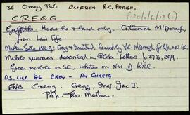
Set of index cards describing some of the local features of the townland of Cregg, [An Chreig]. Included are descriptions of Lough Nahillion (na h-uillin), the Children's Burial Ground, Poll an Phíobaire, Corach, Aill na Síog, Aill Mhairtín, Eas Mór, Aill an 'Challenge', Keelogs, Tulaigh tSrutha, Marble Quarries, and Lower Cregg Falls. Rory Lavelle is credited with providing some of the local information.
UntitledIreland : Townland)
217 Archival description results for Ireland : Townland)
Set of index cards describing some of the local features of the townland of Derreen. Included are descriptions of a Megalithic Tomb and nearby ringfort. A small doodle is also included. A note on the card indicates Tim visited this in 1989.
UntitledSet of index cards describing some of the local features of the townland of Cruagh Island (An Chruach). Included are descriptions of The Bills of Cruagh, Hermit's Cell, and a note on Cruagh including information from various secondary sources. Rory Lavelle and Mike Gibbons are credited with providing some of the local information.
UntitledSet of index cards giving a description of the townland of Doon, [An Dún]. Included are descriptions of Doon House, which was demolished c. 1975. Also Caisleán an Dúna, and Tulach. Peter and Ann Molloy of Cushatrough are credited with providing some of the local information.
UntitledSet of index cards giving a description of the townland of Emlagh, [Imleach]. Included are descriptions of Sellerna Church, the rectory of which was demolished, and its outhouses converted into the house now called 'The Old Rectory'. The headstone of a sailor in the British Navy is to be found here. Some information on the church's last minister. Also described are Sellerna School, Sellerna Bay where a wedge grave known as Leaba Dermot can be found, and the children's burial ground also found by the bay.
UntitledSet of index cards giving a description of the townland of Fahy, [An Fhaiche]. Included are descriptions of Giorrán's, Fuach Thaidhg, Promontory Fort, and Cloch an tSaighdiúra. A Mr. Mullen and Mr. Grath are credited with providing some of the local information.
UntitledSet of index cards giving a description of the townland of Glen, [An Gleann]. Included are descriptions of rock shelters (possibly Booley huts), Loch na h-uamain (the lake of the cave), Farawan Lake (the local pronunciation, Lough Nawarawaun on the OS maps), and Meall agus Caorán. Mike Gibbons, and Philomena and Tom Welsh of Cushatower are credited with providing some of the local information.
UntitledSet of index cards giving a description of the townland of Inishturk, [Inis Toirc]. Included are descriptions of Black Stick (a hill), Cara Chnoic, Baile Thoir, Baile Thios, Cuainín, Reilg, Caibidie, An tOileán Íseal, Glasoileán, Caladh Mór, Cnoc na Móna, Maoilín, Fuach Mhór, Carraig Mhuiris, and Tóin Rua. Mr. Hannon or Inishturk, and Mr. McDonagh of Eyrephort are credited with provoding some of the local information.
UntitledSet of index cards giving a description of the townland of Knockavally, [Cnoc an Bhealaigh]. Included are a rough sketch of Knockavalley wedge (dated 26 July '06), The Three Stones (a megalith, includes a small sketch), and Kingstown Church.
Untitled