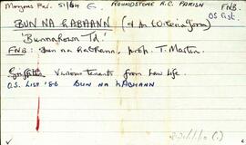
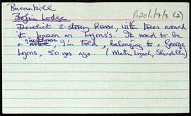
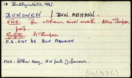
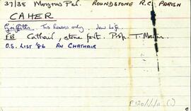
Overview list of the following townlands within the Roman Catholic Parish of Ballynakill or Letterfrack, which coincides with the Civil Parish of Ballynakill. The cards include the Irish and English language renditions of the townland names.Addergool [Eadargúil], Ardkye [Ard-choill], Ardnagreevagh [Ard na gCraobhach], Attirowerty [Áit Tí Robhartaigh], Ballynew [An Baile Nua], Bawnoge [An Bhánóg], Bundouglas [Bun Dúghlaise], Bunowen [Bun Abhann], Cashleen [Caislín], Cartron [An Cartrún], Cleggan [An Cloigeann], Cloon [An Chluain], Clooncree [Cluain Crí], Cloonaderowen [Cluain Idir Dhá Abhainn], Cloonlooaun [Cluain Luáin], Cnocnaraw [Cnoc na Rátha], Crump Island [Oileán Dá Chruinne], Culfinn [Cúil Finn], Curragh [An Currach], Currywongaun [Corr Uí Mhongáin], Dawros Beag [Damhros Beag], Dawros More [Damhros Mór], Derryherbert [Doire Hoirbirt]. Derryinver [Doire Inbhir], Derrylahan [Doire leathan], Derrynacleigh [Doire na cloiche], Dooneen [An Dúinín], Finnisglinn [Fionasclainn], Foher [Fothair], Garraunbaun [An Garrán Bán], Glassillaun [Glasoileán], Glencraff [Gleann creamha], Gleninagh [Gleann eidhneach], Gorteennagloch [Goirtín na gcloch], Illion [An Uilinn], Kanrawer [An Ceann ramhar], Keelkyle [Caol choill], Knocknahaw [Cnoc na háithe], Kylemore [An Choill Mhór], Lecknavarna [Leic na bhFearna], Lemnaheltia [Léim na hEilte], Letterbeg [Leitir Beag], Letterbreckaun [Leitir Breacáin], Letterettrin [Leitir eitreann], Letterfrack [Leitir Fraic], Lettergesh East [Leitir Geis Thoir], Lettergesh West [Leitir Geis Thiar], Lettermore [Leitir Mór], Lettershanbally [Leitir seanbhaile], Luggatarriff [Log an Tairbh], Maumfin [Mám Fionn], Moyard [Maigh Ard], Mullaghglass [An Mullach Glas], Mweelin [An Maoileann], Pollacappul [Poll an Chapaill], Ross [An Ros], Roscrea [Ros Cré], Rosleague [Ros Liag], Rosroe [An Ros Rua], Rusheenduff [An Roisín Dubh], Salrock [Salroc], Shanaveag [Sean Mheidhg], Shanboolard [An tSean buaile Ard], Sheenauns [Na Siáin], Tievegarriff [An Taobh Garbh], Tievemore [An Taobh Mór], Tonadooravaun [Tóin an Dúrabháin], Tooreen [An Tuairín], Tooreena [Tuairín Áithe], Tooreenacoona [Tuairín Uí Chuana], Tullybeg [An Tulaigh Bheag], Tullyconor [Tulaigh Uí Chonchúir], Tullymore [An Tulaigh Mhór], and Ungwee [Eang Bhuí].
Robinson,Tim