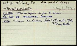
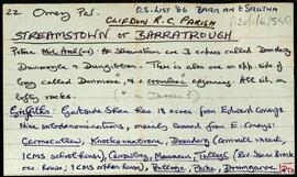
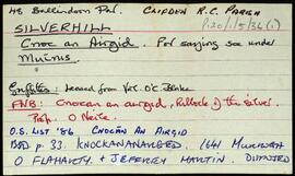
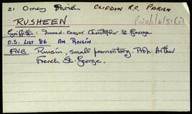
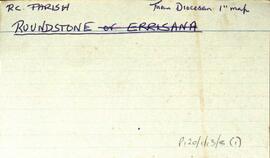
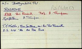
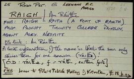
Ireland : Townland)

Elements area

Taxonomy

Code

Scope note(s)

    Source note(s)

      Display note(s)

        Hierarchical terms

        Ireland : Townland)

          Equivalent terms

          Ireland : Townland)

            Associated terms

            Ireland : Townland)

              217 Archival description results for Ireland : Townland)

              217 results directly related Exclude narrower terms
              Oiriúlach [Oirbhealach]
              UGA P/P120/1/1/50/1 · Item
              Part of Personal

              Set of index cards describing some of the features of Oiriulach [Oirbhealach/Ervallagh]. Features described include Creig Dú (Creggduff), Leave Mhaoil, Crompán, Grant's Lifting Stone, Foyle Harbour, Baile Robuck, Cloch na Rón (Roundstone Rock), and Ellistrum Lodge, where De Valera visited upon his release from prison. Local sources credited with providing information include John Morgan, Bernard O'Toole, Joe Rafferty, and Rosaleen Mills.

              Untitled
              Leitrí
              UGA P/P120/1/1/44/1 · Item
              Part of Personal

              Set of index cards describing some of the features of Leitrí [Lettery]. Leitrí is the location of Benlettery Youth Hostel, and also the peak Binn Leitrí, sometimes known as Bindowglass [Bendouglas/Binn Dúghlais]. At the foot of the mountain is a lake, where a fair was held. An anecdote from James Berry's 'Tale of the West of Ireland' is included.

              Untitled
              Cloch na Rón
              UGA P/P120/1/1/55/1 · Item
              Part of Personal

              Set of index cards describing some of the local ecclesiastical, historical, and geographical features of Roundstone, [Cloch na Rón]. Background information sourced from Hardiman, and from the 1849 sale of the Martin Estate which covers the building of a pier there by the Fisheries Board and Alexander Nimmo. Included in the descriptions are the 19th century Protestant Church and its memorials, the Presbyterian Meeting House which was demolished in 1930, the Presbyterian Church, the Franciscan Monastery, The Fort, (occupied for a while by Sting of 'The Police'), The Old Store, Garryowen, Srutháin na Srúille, the Harbour, Ballagh House, Roundstone Bay, Waymount, Clougherty's (a shop and pub, and the site of the current Garda station), Bólard, the Coastguard's Office (referred to as The Boat House in 1899 map), Farrell's Road (a site of several Famine graves), Ballagh House, Newton Buildings (now the site of the local Health Centre), The Old Quay, the Catholic Church which was built in 1830, and the knitting factory. Summary of some of the information from the Royal Commision of Inquiry into the State of Irish Fisheries, 1836, from the Roundstone Famine Relief Committee, and from the Martin Estate Sale document of 1849. One card giving an account entitled 'The Story of Alice', referring to Alice McCaulter. Noel King, Michael Verron, M. Bairéad, and John McQuaid are all credited with providing some of the information and anecdotes in these notes. The Galway Vindicator was also a source of information about the Roundstone Famine Relief Committee.

              Untitled
              Cill Chiaráin
              UGA P/P120/1/2/11/1 · Item
              Part of Personal

              Set of index cards describing some of the features of the townland of Cill Chiaráin [Kilkieran]. One card summarising information from the Irish Wasteland Improvement Society. Features described include An Gleann Mór, Glenmore House (a history of its ownership), Teach Pobail Chill Chiaráin (which dates back to 1879), Comharchumann Chonamara Thiar, a note on the Irish Salmon Producers Group, Crocán na Sealaíocht, Cnocán na mBuachaillí, Tobar Muire, St. Kieran's Church (known locally as Leaba Chiaráin, Caladh na gClimíní, Droighneach, Cnoc Binn Bhuí, Cionlaí, Aill na Brón, Bánrach Árd, An Chathair, Coradh na gCuaig, Sliabe Doite, An Bhrocach, Crompán Bréan, Crompán an Mhaide, Cloch na gCailleach, Crompán an bhFiann, Carraig Mhór, Loch na Sióige, Aill na Méaracán, Cora na gCapall, Oileán an Charnáin, Log Riabhach, An Roisín, a card listing some of the businesses in the village of Cill Chiaráin, Crompán Beag, An Crompán Mór, Loch an Óir, and Abhainn an Mhuilinn. Some local people are named, credited with providing some of the information about the townland. These are Seán O'Ceoinín, Martin Smith, Eoin O'Néill, Máire Canavan, M. O'Conghaile.

              Untitled
              Carna
              UGA P/P120/1/2/9/1 · Item
              Part of Personal

              Set of index cards describing some of the features of the townland of Carna. Description of Annála Beaga, a pub built by a priest, which later sold fishing gear. Included in the descriptions are the RIC Barracks (a fellow of the ruined barracks in Caherciveen), Cúbh an Chrompáin, Poll an Athar Peadar, Teach Phobail Naomh Maire, Idir Dhá Locha, An Sruthán Dearg, Ruaoileán, An Chréibhín, Cora Bharr na hAbhann, Loch na Lannach, Abhainn Bheag, Abhainn na Seainimhe, Loch na Calgaí, Lathach na bhFód, Na Dolachta Móra agus Beaga, Oileán an Fhiaich, Oileán na Scuaibe, Na Searaí, Baile an tSléibhe, An Tulach, Abhainn Charna, Caorán Chárna, Roisín na Tamhnaí, Dothulach, Cluais Ghiorria, and Loch Céim na Caillí. Seán Ó'Ceoinín, a Bourke of An Troscán, J Guairim, Roisín Ní Mainiach, and John Mercer credited with providing some of the information.

              Untitled
              An Coillín
              UGA P/P120/1/2/10/1 · Item
              Part of Personal

              Set of index cards describing some of the features of the townland of An Coillín [Cuilleen]. Included in the descriptions are Mass Rock, Tóin Naigín, Caladh Mhacaí, Gleann an Tobair, a cave sometimes known as Poll an Phíobaire, An Choraínn, Abhainn an Mhuilinn, Abhainn an Choillín, Lough Corker, Gleann an tSéideáin, Loch na Tulaí Buí, An Píosa Réidh, Loch an Amoileáin, Carraig Eanoinn, Aill a Gharrett, Poll an Mhianaigh, Cuan an Choillín, An Coréal, Roisín an tSamha, Loch an Gharraí, Scailp Mhór, An Sean-gharraí, Poll an Chiste, Garraí Thaidhg Mhór, Loch Mhaoilre, and Cnoc an Choillín. E O'Neill, Sgt. P O'Conghaile/Conaola, and Bríd Bean Uí Chonaola credited with providing some of the information.

              Untitled
              Doire Iorrais
              UGA P/P120/1/2/16/1 · Item
              Part of Personal

              Set of index cards describing some of the features of the townland of Doire Iorrais [Derryrush]. Included in the descriptions are Loch an Bhaile, Reilg na bPáistí (more commonly known as An Chill Bheag), An Liocáin Mór and An Liocáin Beag, Bóthar na Cuinge, Bun Inbhir, Loch an Doirín (Lough Aderreen on the OS map), An Cíocrach, Éasc Glasóg, Droim Bharr na hAbhann, Céibh Liocáin, Loch Liocáin, Binn an Duine (a cliff face named after an 18 year old who fell there), and Loch Choirill (a now empty fishing lodge on the lake island). P MacDonncha and Pat Sullivan credited with providing some of the information.

              Untitled
              An Cnoc Buí
              UGA P/P120/1/2/12/1 · Item
              Part of Personal

              Set of index cards describing some of the features of the townland of An Cnoc Buí [Knockboy]. Included are descriptions of Loch na hAircín (sometimes known as the Black Lake, sometimes as the Runt Pig), the Forest Lodge and Forestry, An Cnoc Buí, Gleann na Teorann, Troiscín na Neach, Loch Buaile, Bóthar na Scológ (the scene of many ghost sightings), Loch na nÉan, An Clochar Gorm, Loch an Choiléir, and Bóthar na Tornóige. Seán Ó'Ceoinín credited with providing some of the information.

              Untitled
              Glinsce
              UGA P/P120/1/2/23/1 · Item
              Part of Personal

              Set of index cards describing some of the natural physical features of the townland of Glinsce [Glinsk]. Various sources are referenced giving insights into the origin of the placename, from Patrick Weston Joyce's 'The Origin and History of Irish Names of Places, Vol 3', which interprets it as the glen of the bramble bushes, to a local man who believes it derrives from 'gleann uisce'. Some notes are also provided on the modern day uses of buildings referenced in the OS maps, for instance the local school, Glinsk House, and Marble Studio. The physical features described are Loch an Roisín, Rusheen Point, Cnoc Glinsce, An Charraig Leith, Caladh Beag, An Caladh Mór, Corrán, a Children's Burial Ground, Loch Bhairtle, Barr an Linnín, Cnoc Bharr an Linnín, Abhainn Bharr an Linnín, Loch Cnocán na gCalapp, Caladh Thiobóid, Loch na Dubhaí (Lough Peastia on the OS maps, from the Irish word for worm, péist), Loichín Bharr an Chriathrach, Barr an Chlaí, Loch an Chaoráin, Céibh an Chaltha Mháire, Loch an Tamhnaigh, Tamhnachaí, Loch na Liathróide, Tulach na mBan, Loch an Mheill Mhóir, Tobar Mhuire, and Cuan na Beirtrí Buí. Information sourced from Bedford's map, Annála Beaga, and locally from Seán Ó'Ceoinín, Josie McDonncha, Frank Keaney and his grandmother, Josie Phádraig Cionnaigh, and Tomás Ó'Conghaile.

              Untitled
              Gabhla
              UGA P/P120/1/2/21/1 · Item
              Part of Personal

              Set of index cards describing some of the features of the townland of Gabhla [Gowla]. Some historical information from Griffith's Valuation, and from the 1849 sale of the Martin Estate is included, which notes a salmon fishery was held by Daniel Bowden Smith on lease on Gowla River and lakes. Included in the descriptions are Abhainn Ghabhla (Owengowla), Loch an Duine (occasionally this is named Loch Marú an Duine locally, the site of where a man was killed for the half crown in his pocket), Loch na nOileán (Loughanillaun on the OS, known by the Fisheries as Gowla lake, and locally as Loch Barr na hAbhann), Loch an Aonoileáin, Barr na dTamhnach Gabhla, Loch Crocán na Gaoithe, Loch an Chlochair, Loch na mBreac Geal, Loch na Maidí, Cnoc Seana na Sith (some notes on the confusion behind its name), Coill an Gháigín, Sruthán na Teorann, Gabhla Bay/Cove, Loichiní Choill an Gháigín, Loch Tulaí Buí, Poll Sáile, Loch an Dín, Eas Mór, Gabhla Mór, Loch Fhada, Abhainn Ghabhla Beag, An Cnoc Breac, Loichín Salach, Loch na Tamhnái, Loch an Fhideáin, Loch Cúl an Dhrama, Loichín Caoch, and Gleann Aill an Tarra. Patrick King and Mike Coyne are two local sources credited with providing information.

              Untitled