An index card devoted to the townland of An Leathchartúr, [Cartron]. A reference to Griffith's Valuation, Patrick Blake was the occupier in fee on the land at the time.
Robinson,TimIreland : Townland)
217 Archival description results for Ireland : Townland)
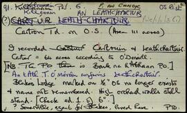
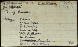
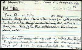
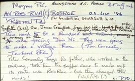
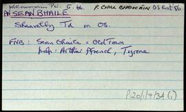
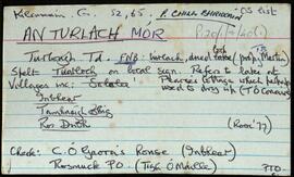
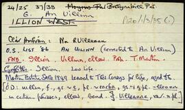
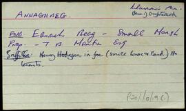
A set of index cards describing some of the local features and the history of the townland of An Máimín, [Maumeen]. Brief descriptions are given of the following features, Abhainn an Damba, Cloch na Scíthe, Gort an Mhoill, Caladh na Leice, An Léana, a note on the Abbey, An Muileann, An Roisín, Cuan an Mhuilinn, Gleann an Dreoilín, Nead na Gé, Clochar na dTaibhsí, Loch an Ghainimh, Tobarín Ghleann an Uisce, Loch an Mhuilinn, Tobairín an Átha Leacaigh, Leoghoill, Geabhróg, Cnocán an Aifrinn, Oileán Ros na nEas, Aill na Cora, Muiltín an Oileáin, Cloch an Troughlic (phonetic spelling), Cora Gaineamh, Lois an Druim, An Clár, Geabhróg, An Cartúr, An Meall Glas, Droim, Máimín ó Thuaidh, Loch Bran, Loch na gCeann, Droichid Carraig an Lugáin, Poll na gCearc, Gleann Trasna, Cnoc an tSáilín, Seana Luinn, Céibh an Mháimín, Loch Gleann an Uisce, a note on Pádraig Ó'Clochartaigh, Seanachomh-Mheas, Poll Uí Mhuirinn, Carraig na mBan, Na h Uaimíní, Oileán na bPéarlarach, Céibh an tSáilín, Sáilín, An Talamh Bán, Cara Bheag, Crompán na nUaimíní, Crompán na Muice, Tobairín Carraig Mhurchú, An Portach, Dúlracht, Carraig an Dúthracht, Caladh Bhulustruin, Léim an Ghabhair, An Crompord, Loch Baile na Cille, Loch Tomás, Liochín an Dúigh, Sruthán idir Dhá Shliabh, Garraí an Cheannaí, Cara Uí Mháille, An Maoilín, Cnocán an Chuainín, Tobar na Sceirthí, Carraig Uí Chaonagh, An Chora Rua, Cloch na Fionnóige, Loch an Phúca, An Bhuailteach, Cora Dhónaill, An tAircín, Loch na Fionnóige, Cora na Cleithe, Lochán na Chuana, Carraig na nGall, Poll na hAille Móire, Aill Mhór an Droma, An Máimín, Baile na Cille, Loch Bhaile na Cille, Cloch an Tortáin, Loch Hoibeard, An Seanbhaile, the Church of the Immaculate Conception, Loch an Bhalla, Gleann Bhailís, and Oileán an Anama. Pádraig Ó'Cualáin is credited as being a local source of information.
Robinson,TimSet of index cards describing the local features of the townland of An Más [Mace]. Features described include Carrig A Mungan, Béal an Mhása An Murlach, Céibh an Mhása (a pier shown on the OS maps), Loch an Phúca, Crompán na gCapall, An Fhuaigh, Na Roisíní, An Damba, and Barr an Mhulaigh. As well as Nimmo's 19th cntury map and un-named local sources of information, Seán McDonncha is credited with providing some of the local information.
Robinson,Tim,McDonncha,SeánSet of index cards describing some of the features of An Ros Rua [Rosroe]. Robinson quotes local sources in summarising the history of the village in the 19th century, once quite a busy harbour, but declining as a village early into the Famine. Features described include the Rosroe Boat Harbour, a marsh North-West of Rosroe Lough called Muing Sanders, Cnocán Rí, Tamhnach Mór, The Lily Lake, Rosroe Bay, Bun a Trinse, Caladh Bháid Mhóir, Cora an Trá, The Poorhouse, Sruthair na Míoltóg, Cora an tSalainn, Loch Stiofáin Uí Mhongáin, Cora Phádraig, Cora Raithní, Loch Barr an Bhaile (where Marconi experimented with kites), and Locháin an Dubhaigh (The Mud Holes). Credited with providing information are Tom and Peter Conneely, Joe Joyce, Tom Conneely, and Joe Joyce.
Robinson,Tim,Tom Conneely,Peter Conneely,Joe JoyceSet of index cards describing some of the local features of An Seanbhaile, [Shanvally]. Included are descriptions of Reilig Sheanadh Mhaoilín, and Crocán na Fola.
Robinson,Tim,Ó'Conghaile,Séan NeideSet of index cards describing some of the local features of An Turlach, [Turlough]. Included are descriptions of Teach an Phiarsaigh (Pádraig Pearse's cottage), An Príosún, Loch an Oileáin, Inver Lodge (some details of its inhabitants over the past couple of centuries), Bóithre na n-uaisle, Inver and Screebe Fishery, Abhainn Inbhear Beag, Invermore Fishery, Inverbeg Estate, Loch na Scailpe, Reilig Chill Eoin, Tamhnaigh Bhig, Loch Uachtar na hAibhne Gairbhe, Ro Dubh, An tSruthair Mhór, Loch Lathach na gCapall, An Crompán, Carraig Bhúi Thiar, Loch an Loigín Beag, Crompán an tSrutháin, Cnocán na Móna, Carraig an tSeagail, Carraig na Cruithneachta, Carraig na hEorna, Céibh an Oileáin, An tSruthair Mhór, An Chara Dhubh, Ros Locha, Crompán Aill an Mhianaigh, Lochán an Bhrandy, Loch an Aonoileáin, Loch an Éadain, Loch an Phaiste, Tigh Choilm Uí Ghaora, Bóithrín 'Feather', Loch Bhun na hEasc, Cnocán an Phiarsaigh, An Turlach, Loch Eiliúrach, An Caladh Caol, Inbhear Glasain, Bóithrín an Loigín, Bothar Cloch na Leachta, Carraic Loiscthe na Ceilpe, Nead na Cároige, An Aill Mhór, Loch Inbhear Mór, Loch Bun na hEasc, Loch Iochtar na hAbhna Gairbhe, Loch Inbhear Beag, Na Creigeáin, Loch na hAille Daraí, Abhainn Inbhear Mór, and Inbhear. Robinson indicates that he relied on a lot of local knowledge in compiling the information for An Turlach. He specifically mentions Seán Ó'Mainnín, Peter Joyce of Úraid, Mícheál Ó'Ní, and references Noel P Wilkins' book, and Colm O'Gaora's 'Mise'.
Set of index cards describing some of the local features of the townland of An Uillinn, [Illion]. Included are descriptions of Cnoc na hUilleann, and a reference to the Field Name Books small names index.
Robinson,TimSet of index cards describing some of the local features of the townland of Ardagh, [Ardach]. Included are descriptions of a megalithic tomb, earthworks, rock carvings, Derrywaking Lough, Mass Rock, the estate of P J Kendall, Ardagh House and Lodge, Ardagh Oyster Fishery, and Loch na Fiacaile. Paul Mohr who discovered the rock carvings, Professor Noel Wilkins' book, and the Connery brothers of Becaunín are all credited with providing information.
Robinson,Tim,Mohr,Paul,Wilkins,Noel