Ireland : Townland)
217 Archival description results for Ireland : Townland)
217 results directly related
Exclude narrower terms
UGA P/P120/1/1/42/1
·
Item
Part of Personal
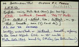
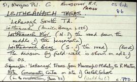
Set of index cards describing the physical features of Leitheanach Theas [Lehanagh South]. Some description about the demarcation between Leigheanach Mór, Beag, and on the translation of the place name. Features described include Cnoc an Aoire, Red Island, Barr na gCrompán, Loch Beag, Doire Mhian, Bun na Greallaí, Loch na Lurgan, Bun na Teorann, The General's Cora, Roisín (a small peninsula), Carraig an Ghlais, Cora Bhán, Caladh na Beirtrí, Gob an Chlochair, Aill Mhór, An Choill Bheag, Carraig na Sruthair, Loch Sligeach, Mary's Island, Gob an Doirín, Tóin an Chnoic, Leitheanach Mór Hill (where Marconi had a mast), Loch na Meall Breac, Clochar an Bhrandy, Aill na Mallacht, Kingstreet, and Bóthar na Scrathóg (the bog road to Doire Iorrais). Some local people are credited with providing information, and these are named as Paddy Nee's son, Pete Lydon, Mike Cunningham, and Joe King of Roundstone.
Robinson,Tim,Lydon,Pete,Cunningham,Mike,King,Joe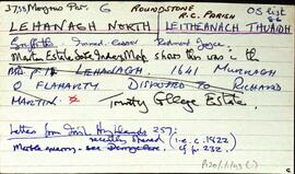
UGA P/P120/1/1/43/1
·
Item
Part of Personal
Set of index cards describing the physical features of Leitheanach Thuaidh [Lehanagh North]. Features described include Gabhal an tSrutháin, Loch Rua, Loch Leitheanach, within which is a wood island, An tOileán Mór, and Abhainn Leitheanach (Owentooey River on the OS maps).
Robinson,Tim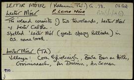
UGA P/P120/1/11/14/1
·
Item
Part of Personal
An index card devoted to the townland of Leitir Móir, [Lettermore]. Leitir Móir and Leitir Caltha (Leitir Calaidh) are on the same island. Christopher St. George was the lessor at the time of Griffith's Valuation. A note on An Teach Mór, Inishbay, Oileán Gorm, An Muirbheach, Carraig na Láibe, the local church built in 1958, Céibh Leitir Móir, Cora Ghiolca, An Doirín Glas, An Sconsa, Droichead Carraig an Lugáin, Céibh an Sconsa, Croimineach, Bun an Fháil, Lettermore House, Cuan an Doirín Glas, Oileán na dTráchta, Céibh na Leice, Tobar Cholm Cille, Oileán an Ghréasaí, Carraig an Iolra, Cnoc Leitir Lóir, Brandy Harbour, An Tráchta, and Céibh na dTráchta. N. Ó'Conchubhair, Tomás Ó'Conghaile, and Claire Ní Tuathail are credited as being local sources of information.
Robinson,Tim,Ó'Conchubhair,N.,Ó'Conghaile,Tomás,Ní Tuathail,Claire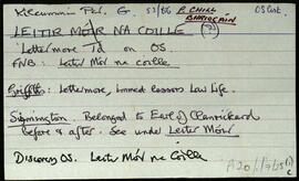
UGA P/P120/1/7/25/1
·
Item
Part of Personal
Set of index cards describing some of the local features of Leitir Móir na Coille, [Lettermore]. Included are descriptions of na hÁitheanna, Cnocán an tSoiscéil, An Scailpín, Seana na Sagart, Na Briciúin, and Leaca Donna (so named because of the danger of the cliffs there). Seán Neide Ó'Conghaile of Gleann Trasna, and Paddy Folan of Scríb are credited as being local sources of information.
Robinson,Tim,Ó'Conghaile,Séan Neide,Folan,Paddy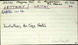
UGA P/P120/1/1/44/1
·
Item
Part of Personal
Set of index cards describing some of the features of Leitrí [Lettery]. Leitrí is the location of Benlettery Youth Hostel, and also the peak Binn Leitrí, sometimes known as Bindowglass [Bendouglas/Binn Dúghlais]. At the foot of the mountain is a lake, where a fair was held. An anecdote from James Berry's 'Tale of the West of Ireland' is included.
Robinson,Tim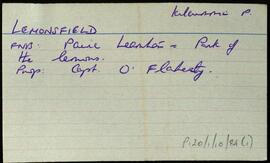
UGA P/P120/1/10/84/1
·
Item
Part of Personal
Index card relating to the townland of Lemonsfield/Lemonfield, [An Chorr]. Páirc Leamhán in the Field Name Books. Illaunacreeva, Cnoc na Cabha, Eanach Clumhach, Oileán Brointín, Bilberry Island, Oileán Chainbhe, Inis Sean Bó, and Kilcomine are briefly described local features of the townland.
Robinson,Tim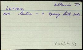

UGA P/P120/1/3/43/1
·
Item
Part of Personal
Set of index cards describing some of the local features of the townland of Letterbeg, [Leitir Beag]. Included are descriptions of Breillín (a small projection of the cliff face in Cuigéal), Duirling na nGabhar, Scailp Nóra Ní Allúráin, Loch an Mháma, Carraig Leathan, Cuainín na nGabhar, Béal Bhráidoileán, Fó na Sáibhéiracht, Fó Jack, Fó Caol, Cuigéal, Trá Mhór/Trá Bheag, and Bráidoileán. Local man Paddy Hearne, and an unidentified local woman are credited with providing some of the information.
Robinson,Tim,Hearne,Paddy
UGA P/P120/1/3/45/1
·
Item
Part of Personal
Set of index cards describing some of the local features of the townland of Lettermore, [Leitir Móir]. A note about some standing stones called Liagain, possibly the remains of a pagan burial ground located here. Also described are Cillín (a children's burial ground), Carraig Ghlas (carrigeenyglassa on the OS), Letter Hill (Tully Mountain on the OS maps), Clochán Fada, and Tóin na Binne.
Robinson,Tim