Ireland : Townland)
217 Archival description results for Ireland : Townland)
217 results directly related
Exclude narrower terms
UGA P/P120/1/7/21/1
·
Item
Part of Personal
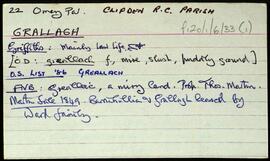
Set of index cards describing some of the local features of Halfcartron, [An Leathchartúr ]. Included are descriptions of Coill Beag (an enclosed hill to the South East of Tullaghnakernishna Hill), and Loch Coill Bheag. A stream in the centre of the townland that Robinson calls Sruthán Mór is also described. Peter Joyce of Úráid is credited as being a local source of information.
Robinson,Tim,Joyce,Peter
UGA P/P120/1/13/4/1
·
Item
Part of Personal
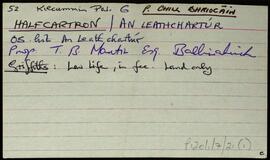
Overview list of the following townlands within the Parish of Inishbofin [Inis Bó Finne]. Inishshark [Inis Airc], Inisbofin [Inis Bó Finne], Westquarter [An Cheathrú Iarthach], Middlequarter [An Cheathrú Láir], Fawnmore [An Fán Mór], Cloonamore [Cluanach Mhór], and Knock [An Cnoc].
Robinson,Tim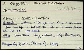
UGA P/P120/1/6/35/1
·
Item
Part of Personal
Set of index cards giving a description of the townland of Inishturk, [Inis Toirc]. Included are descriptions of Black Stick (a hill), Cara Chnoic, Baile Thoir, Baile Thios, Cuainín, Reilg, Caibidie, An tOileán Íseal, Glasoileán, Caladh Mór, Cnoc na Móna, Maoilín, Fuach Mhór, Carraig Mhuiris, and Tóin Rua. Mr. Hannon or Inishturk, and Mr. McDonagh of Eyrephort are credited with provoding some of the local information.
Robinson,Tim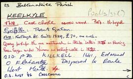
UGA P/P120/1/3/37/1
·
Item
Part of Personal
Set of index cards describing some of the local features of the townland of Keelkyle, [Caolchoill]. The ruins of the house of Captain Máilleach can be seen from here. Included in the index cards are descriptions of Keelkyle Quay, Bulóg, the Standing Stone, Connemara Handcrafts (Quay House on the OS), Dooneenmore (with a tale of a dispute between fairy people about seaweed rights), Ballinakill Lodge, and the Graham family.
Robinson,Tim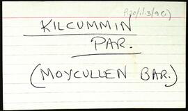
UGA P/P120/1/13/9/1
·
Item
Part of Personal
Overview list of the following townlands within the Civil Parish of Kilcummin, Barony of Moycullen. The cards include the Irish and English language renditions of the townland names.Ardderrynagleragh [Ard doire na gcléireach], Bunscanniff [Bun scainimh], Camas Íochtair [Camus Eighter], Camas Uachtair [Camus Oughter], Cill Bhriocáin [Kilbrickan], Cinn Mhara [Kinvarra], An Cnapach [Crappagh], Cnoc an Daimh [Knockadaw], Cnoc an Phréacháin [Knockaphreghaun], Cnoc na Gairfeann [Knocknagarrivhan], Daimhinish [Dinish], Dereenagusfoor [Doirín na gCos Fuar], Derrough North [Na Doiriú Thuaidh], Doire Bhrios [Derryvrusk], Doire Dhá Bhanbh [Derravoniff], Foirnis [Furnace], Formaoil [Formoyle], Gairfean [Garrivinnach], Glinn chatha [Glencoh], Gleann Mhac Muirinn [Glenicmurrin], Gleann Trasna [Glentrasna], Inis Mhic Cionaoith [Inchamakinna], An Leathchartúr [Halfcartron], Inis Oirc [Inisherk], Inis Mhic Cionaith [Inchamkinna], Lackavrea [Leac Aimhréidh], Leitir Mealláin [Lettermullen], Leitir Móir na Coille [Lettermore], Lurgan [Lorgán], Muiceanach Choille [Muckanaghkillew], Muiceanach Idir Dhá Sháile [Muckanaghederdauhaulia], Úráide [Oorid], Ros Céide [Roskeeda], Ros Muc, An Ros Rua [Rossroe Island], Seana Bhéartha [Shannavara], An Sean Bhaile [Shanvally], Seanana Feola [Shannaunnafeola], Snámh Bó [Snauvbo], An Turlach Mór [Turlough], An Turlach Beag [Turloughbeg], Na hUilinní [Illeny], and Cloon [An Chluani].
Robinson,Tim![Kill [An Chill]](/uploads/r/university-of-galway-archives/7/b/d/7bde64a92137bc115599aa93a9caf79104ae871f72930f7e6efef808c5cd0a95/300_142.jpg)
UGA P/P120/1/5/25/1
·
Item
Part of Personal
Set of index cards describing some of the local features of the townland of Kill [An Chill]. Included is information from the Congested Districts Board, and the Estate of Alex Thompson. A line from the returns in Griffith's Valuation is also included. Included are descriptions of Cill Fhlannáin, Carraig an Iasc, Loch na hAille Gairbhe, Cnoc na Cille, The Manor, Tobar Fhlannáin, and Loch na Cille. M. King is one of the local people credited with providing information.
Robinson,Tim,King,M.
UGA P/P120/1/13/8/1
·
Item
Part of Personal
Overview list of the following townlands within the Civil Parish of Killannin. The cards include the Irish and English language renditions of the townland names.Oileán Iarthach [Illauneeragh], Leitir Móir [Lettermore], Leitir Calaidh [Lettercallow], Inis Bearchain [Inishbarra], Eanach Mheáin [Annaghvaan], and Béal an Daingin [Bealadangan].
Robinson,Tim
UGA P/P120/1/13/2/1
·
Item
Part of Personal
Overview list of the following townlands within the Roman Catholic Parish of Killeen [An Cillín]. Robinson describes this as "The peninsula of An Cheathrú Rua, with Doire an Fhiach and Leitir Mucú, and Garomna and Leitir Mealláin islands). Cards include an Irish and English language rendition of each of the placenames. The following townlands are included.An Cheathrú Rua Theas [Carrowroe South], An Cheathrú Rua Thiar [Carrowroe West], An Cheathrú Rua Thuaidh [Carrowroe North], Leitir Mucú [Lettermuckoo], Barr an Doire [Barraderry], An Caorán Beag [Keeraunbeg], Cladhnach [Clynagh], An Cnoc [Knock], Caolach [Creelogh], Doire an Fhéich [Derrynea], (with a note on the back mentioning Loch Uí Chadhain), Garomna [Gorumna Island], An Máimín [Maumeen] incldes a list of local lakes and points, and Tír an Fhia [Teernee].
Robinson,Tim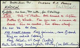
UGA P/P120/1/5/26/1
·
Item
Part of Personal
Set of index cards describing some of the local features of the townland of Knock, [An Cnoc]. Included are a description of Carraig an Bholmáin, sometimes known as Stutter's Rock, with some accompanying information credited to Festy Conneely of Turlot. Malky and Mary Riley of Mannin Beg are also credited with providing information about the northern point, Scoth.
Robinson,Tim,Conneely,Festy,Riley,Malky,Mary