Ireland

Elements area

Taxonomy

Code

Scope note(s)

    Source note(s)

      Display note(s)

        Hierarchical terms

        Ireland

          Equivalent terms

          Ireland

            Associated terms

            Ireland

              22 Archival description results for Ireland

              22 results directly related Exclude narrower terms
              Ceannúir
              UGA P/P120/1/1/14/1 · Item
              Part of Personal

              Set of index cards describing the physical features of Ceannúir [Canower]. Descriptions given are of Tulach Bhuí, Paiste, Cora na gCruicíní, Tráíní, Bealach an Ghiorria, Oileán na Táimhe, Cora an Oileáin, Cora na hAbhann, Tulach and Aill na Tulaí, Staca, Portach Bán, Caladh Pheadair Mhór, Garraí Mór, Aill Uí Ghábháin, Cora Shéamus Uí Chonaire, Cora Mhongáin, Gleann na gCoileach, Cora Leachta, Rua Oileán, Children's Burial Ground and Ceannúir Harbour. Sources of information credited are Tom Conneely, and Joe Joyce, a native of Ceannúir.

              Untitled
              Ceapach Chuais
              UGA P/P120/1/1/13/1 · Item
              Part of Personal

              Set of index cards describing physical features and monuments in Ceapach Chuais [Cappaghoosh]. Descriptions given are of Lough Cappaghoosh, the Children's Burial Ground, Scanadh Ceilt (Owengarre Lough on OS maps, between Cappaghoosh and Lettershinna), Loch na Mionnán (between Cappaghoosh, Lettershinna and Derryadd), Loch an Imligh, Stacaí, Loch Doire Croise, Loch Uí Mhongáin, Loch an Ghé, and a roadside monument at the east end of Lough Tounagh. Sources credited with providing informationi include Jo Creane, Jo Mannion of Garroman, and Mr. O'Malley of Bóth Íseal

              Untitled
              Derryvealawauma
              UGA P/P120/1/1/24/1 · Item
              Part of Personal

              Set of index cards describing some of the physical features of Derryvealawauma [Doire Bhéal an Mháma]. Included in the descriptions are Cnoc Doire Bhéal an Mháma, Port an Dúín, Log Mhám Té, the Children's Burial Ground, Máméan, and Bun an Chnoic. A note on Bun na gCnoc and its status as a Gaeltacht during the Recess school boycott. Local Tamhnach Mór and Leitheanach people are credited with providing some of the information.

              Untitled
              Glengoaghan
              UGA P/P120/1/1/32/1 · Item
              Part of Personal

              Set of index cards describing the local features of the townland of Glencoaghan [Gleann Chóchan]. Features described include a lime kiln, Mám na bhFonsaí (recorded as Mám na Uinsí or rim in some places), Lotaí, Tinteánaí, Trinsí, Binn Dubh (Bencollaghduff on the OS map), The Planted Island, a Children's Burial Ground (a photo of which is included in 'Croí Chonamara'), Bengower, An Sindile (an arable area rich in quartz, and with a lime kiln), Mám Dearg (between Binn Dubh and Binn Bhán), Aill an Torainn, the mines (possibly sulphur), Binn Gabhair, Cnoc Trasna, Loch Cúl an Drama, Log an tSabha, Mám na Gaoithe, Mám an Lotaigh, and Fonsaí Ghaineamh. Local sources credited with providing information include local man Pat Joyce, Dela McAuley and Martin O'Malley, William O'Brien of Lotaí, Mrs Leonard of Ballinahinch Lodge, and John Hynes of Gleann Chóchan. (See also Teivebreen/Taobh Braoin for a brief description of Binn Briain, located between the two townlands).

              Untitled
              Glinsce
              UGA P/P120/1/2/23/1 · Item
              Part of Personal

              Set of index cards describing some of the natural physical features of the townland of Glinsce [Glinsk]. Various sources are referenced giving insights into the origin of the placename, from Patrick Weston Joyce's 'The Origin and History of Irish Names of Places, Vol 3', which interprets it as the glen of the bramble bushes, to a local man who believes it derrives from 'gleann uisce'. Some notes are also provided on the modern day uses of buildings referenced in the OS maps, for instance the local school, Glinsk House, and Marble Studio. The physical features described are Loch an Roisín, Rusheen Point, Cnoc Glinsce, An Charraig Leith, Caladh Beag, An Caladh Mór, Corrán, a Children's Burial Ground, Loch Bhairtle, Barr an Linnín, Cnoc Bharr an Linnín, Abhainn Bharr an Linnín, Loch Cnocán na gCalapp, Caladh Thiobóid, Loch na Dubhaí (Lough Peastia on the OS maps, from the Irish word for worm, péist), Loichín Bharr an Chriathrach, Barr an Chlaí, Loch an Chaoráin, Céibh an Chaltha Mháire, Loch an Tamhnaigh, Tamhnachaí, Loch na Liathróide, Tulach na mBan, Loch an Mheill Mhóir, Tobar Mhuire, and Cuan na Beirtrí Buí. Information sourced from Bedford's map, Annála Beaga, and locally from Seán Ó'Ceoinín, Josie McDonncha, Frank Keaney and his grandmother, Josie Phádraig Cionnaigh, and Tomás Ó'Conghaile.

              Untitled
              Ballynew
              UGA P/P120/1/3/5/1 · Item
              Part of Personal

              Set of index cards describing some of the local features of the townland of Ballynew [An Baile Nua]. Descriptions are given of a 'pair of standing stones', Fuaigh an Sconsa (Ooeyasconsa on the OS maps, and known locally as Fo na Sconsaí), Fó na Bróinge (Tim Robinson believes the cove may be named for its boot-like shape), Fó na Labhráis (Ooeylaunlauraush on the OS maps), Fó na Bhistí, Fuaigh an Duine Mhairbe (Ooeywaria on the OS maps), Binn Ghlais, Fó an Uisce, Fó an Bhradáin, Megalithic tombs close to the Children's Burial Ground, Lios (the site of the former Mission School), and the Shrine, which marks the traditional site of St. Ceannan's beheading. J O'Toole of Moyard, Mr. Heanue of Bundouglas, and Con Mullen of Ballynew are credited with providing some of the information.

              Untitled
              Glencraff
              UGA P/P120/1/3/32/1 · Item
              Part of Personal

              Set of index cards describing some of the local features of the townland of Glencraff, [Gleann Creamha]. Included are descriptions of Aill an Ghabhair, Gabhlóg Struthán Mór, Clochán na Bean Sí, Sruthán Mór, Anacair, Children's Burial Ground, Lug na Coille, Eas Dubh, Doirín, Lug an Fhia, Ceannáin Bhán, Cloch an Domhnaigh, Búcán, Cnocán an Iolra, Aill an Iolra, The Glen River, Pulófra, Megalithic Tombs, the Holy Well (which is locally associated with a St. Craff), Cloichín, and Easca Riabhach. Michael O'Néill and Chris O'Néill are credited with providing the information.

              Untitled
              Lettergesh East
              UGA P/P120/1/3/40/1 · Item
              Part of Personal

              Set of index cards describing some of the local features of the townland of Lettergesh East, [Leitir Geis Thoir]. Included are descriptions of Góra Mór, Binn Chuanna, Scailp na Caillí, Sruthán na Gains, Idir Aill, Barr na Cloiche Duibhe, Caher, Cluain, Poll an Ghaoith, Children's Burial Ground, Carraig an Tiompáin, Acha na nGabhar, Maolchnoc, and Lug na nEach. Credited with providing information are Jenny Conboy, Martin Welsh, and a Coyne from Seanaveag.

              Untitled
              Rusheenduff
              UGA P/P120/1/3/60/1 · Item
              Part of Personal

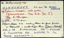
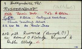
              Set of index cards describing some of the local features of the townland of Rusheenduff, [An Roisín Dubh]. Included are descriptions of Renvyle House Hotel, Rusheenduff Lough, Rinvyle House Hotel (the OS map spelling. Originally this was known as the O'Flaherty's House), Smearoid, Blakes of Renvyle, Liagaun, Renvyle Roman Catholic Chapel, Bun an Chlaí, Children's Burial Ground, Carraig an Choismeig, An Staca, Cuainín na Rón, Duirling, Maolán Dubh, Na Méaracháin, Carraig Amuigh, Cloch Mór, and Smearóid (possibly another name for the Children's Burial Ground).

              Untitled
              Cregg
              UGA P/P120/1/6/18/1 · Item
              Part of Personal

              Set of index cards describing some of the local features of the townland of Cregg, [An Chreig]. Included are descriptions of Lough Nahillion (na h-uillin), the Children's Burial Ground, Poll an Phíobaire, Corach, Aill na Síog, Aill Mhairtín, Eas Mór, Aill an 'Challenge', Keelogs, Tulaigh tSrutha, Marble Quarries, and Lower Cregg Falls. Rory Lavelle is credited with providing some of the local information.

              Untitled