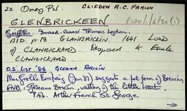
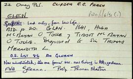
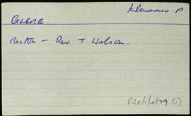
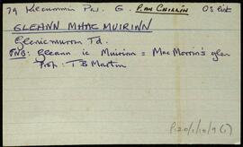
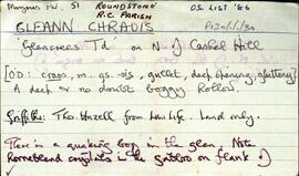
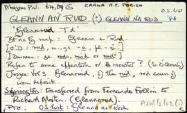
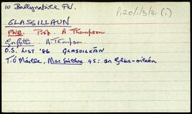
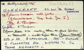
Set of index cards describing some of the local features of the townland of Glencraff, [Gleann Creamha]. Included are descriptions of Aill an Ghabhair, Gabhlóg Struthán Mór, Clochán na Bean Sí, Sruthán Mór, Anacair, Children's Burial Ground, Lug na Coille, Eas Dubh, Doirín, Lug an Fhia, Ceannáin Bhán, Cloch an Domhnaigh, Búcán, Cnocán an Iolra, Aill an Iolra, The Glen River, Pulófra, Megalithic Tombs, the Holy Well (which is locally associated with a St. Craff), Cloichín, and Easca Riabhach. Michael O'Néill and Chris O'Néill are credited with providing the information.
Robinson,Tim,O'Neill,Michael,ChrisIreland
667 Archival description results for Ireland
Set of index cards giving a description of the townland of Glenbrickeen, [Gleann Bricín]. Included is a description of Fiodán Trasnaigh, the stream flowing from the north into Glenbrickeen Lough. T. Joyce is credited as being a local source of the information.
Robinson,Tim,Joyce,T.Set of index cards giving a description of the townland of Glen, [An Gleann]. Included are descriptions of rock shelters (possibly Booley huts), Loch na h-uamain (the lake of the cave), Farawan Lake (the local pronunciation, Lough Nawarawaun on the OS maps), and Meall agus Caorán. Mike Gibbons, and Philomena and Tom Welsh of Cushatower are credited with providing some of the local information.
Robinson,Tim,Gibbons,Mike,Welsh,Philomena,TomSet of index cards describing some of the local features of Gleann Trasna, [Glentrasna]. Included are descriptions of Tobar Mhiuceanach, Loichín na hÁithe, Croc Ghleann Transna, Clochar na Spíocán, Loichín na Calgaí, Loch Ghleann Trasna, Loch na Spiorthe, Cnocán an Bhodaigh, Brocach an tSionnaigh, An Geata, and Aill an Ghlais. Localman Seán Neide Ó'Conghaile, and Paddy Folen of Scríb are credited as being local sources of information.
Robinson,Tim,Ó'Conghaile,Seán Neide,Folen,PaddySet of index cards detailing some of the local features of the townland of Gleann Mhac Muirinn [Glenicmurrin]. Part of the Martin Estate. A brief note on Holly Island and Rook Island, and on Lough Cloonelola, Lough Derreenacummer, and Loughcloonadoon.
Robinson,Tim,Folan,Tom,Ní Dhonncha,Maggie PheigínAn index card describing the townland of Gleann Chraois [Glencrees]. Features descried on a card include a quaking bog, horneblende crystals have been found near Cashel Hill, and a couple of sheep shelters.
Robinson,TimSet of index cards describing Gleann na Rod [Glenaruid]. Some speculation on the meaning of the placename derived from various sources. A note from Robert Simington's 'Books on Survey and Distribution' about the transfer of the lands of Glannarud from Ferdinando Follin to Richard Martin. A note on Loch Cruinn, or Glenaruidmore Lodge on the OS maps.
Robinson,TimSet of index cards describing some of the local features of the townland of Glassillaun, [Glasoileán]. Included are descriptions of the Church site and a mass rock, a bed outshot, Oileán Mór, the Boat Quay, Carraig Ghlais Mhór/Bhig, Fuaigh Bharbh, Carraig Ghéar, Carraig Lachaí, Oileán Liaim, the Camper headland by the harbour, Oileán an Uain, and Gob an Roisín/Glassillaun Point. Local man Peter Welsh, and a letter provided by Martin Joyce are credited as being sources of information.
Robinson,Tim,Welsh,Peter,Joyce,MartinIndex card for the townland of Garrynagry, [Garraí na Graí].
Robinson,Tim