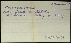
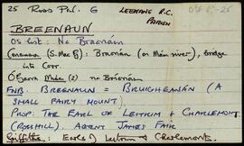
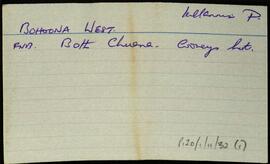
Index card describing some of the local features of the townland of Bohoona West [Both Chuanna Thiar]. Saile Lúna is one of the local features described.
Robinson,TimIreland
667 Archival description results for Ireland
Index card describing some of the local features of the townland of Boleyvaughan, [Buaile Uí Bhánáin].
Robinson,TimIndex card describing some of the local features of the townland of Boliska Eighter [Both Loiscthe Íochtair].
Robinson,TimIndex card describing some of the local features of the townland of Boliska Oughter [Both Loiscthe Uachtair]. Loch na ngabhar, and loch an oileáin mór are included in the descriptions.
Robinson,TimSet of index cards describing some of the local features of the townland of Boolagare, [An Bhuaile Ghéar]. Included are descriptions of Garraí Sheáin ác Con Rí, Lough Áinín Rua, and Loch Gear. Mark Conry and Michael Gould of Emlaghmore are all credited with providing some of the local information.
Robinson,Tim,Conroy,Mark,Gould,MichaelSet of index cards describing some of the local features of the townland of Boolard, [An Bhuaile Ard]. Included are descriptions of The Priory (the big house on the south of the road opposite Boolard Island, sometimes known as The Bishop's House), The Bishop's Rock, Copper Mine (marked as shaft on the OS), Boolard Island, and a note on Reverend Anthony Magee who was a significant land owner in the area in the 19th century. Patrick Joyce of Coolacloy is credited with providing some of the local information.
Robinson,Tim,Joyce,PatrickSet of index cards describing physical features in Both Íseal, [Boheeshal]. A note to say the townland is not a Gaeltacht speaking area. Included are information about Loch Coirill, Cloch Coirill, and Criathrach Coirill. One card deals with translations of the townland name. Also mentioned are Loch Pholl an Mhaide Giúse, Cloch Leathbhealaigh, and the Figure Eight (two lochs joined by a few yards of stream). Several hillocks are also described, Tulach Pheadair, Tulach Poirín, Tulach Glas, Liagan Mór/Beag, and Tulach Srutháinín. There is also a Loch Tulach Srutháinín, which appears as Loughaunemlagh on the OS maps. Loch an Fhraoigh, which appears as Lough Duff on the OS maps. Finally Clogher, and Loch an Clogher. Sources of information for Both Íseal were P. Joyce and his son Úraid, and Mr. O'Malley.
Robinson,Tim,Joyce,P.,ÚraidIndex card describing some of the local features of the townland of Bovroughaun, [Both Bhrocháin]. Loch Aill Mhaintáin is included in some of the descriptions of the area.
Robinson,TimList of local features for the townland of Brannock Island [Oileán Dá Bhrannóg], part of the Civil Parish of Árainn, Inishmore. Cló Droimín, Carraig Jácom, Poll an Bhráca, An Aircín, An tUlán Buí, An Scailp, Carraigeachaí Báite, An Dul, An Trá Bhig, An tOileán Iarthach, Scailpt na mBallach Mór, Carraig Fhada, An Bodach Crom, An Clochar Bán, Leic na Creathnaí, An tOileán Thiar, An tOileán Thoir, An Breachlainn, Carraig Éamonn Rua, Oileán an dá Bhranóg/Bhruithneog, Leacrachaí Buí, Cloch Phádraic Póil, Carraig Chiúin, Cloch Scoilte, An Caladh, Leic Uí Scannláin, Poll Gorm, Carraig Dhubháin, and Carraig Eamonn mhac Donnacha.
Robinson,TimA set of index cards outlining some of the local features of the townland of Breenaun, [Na Braonáin]. Summary notes outlining the origin of the placename (a small fairy mount according to the OS Field Name Books), its proprietor at the time of Griffiths Valuation, and descriptions of a mass grave of famine victims, Log an Ime, a ruined Abbey, 3 steep mountains, and Breenaun Bridge. A detailed note on Sruthán an Leachta, local lore on the origin of the name 'Braonán', some illustrations of different headstones in the graveyard, and Leacan.
Robinson,Tim