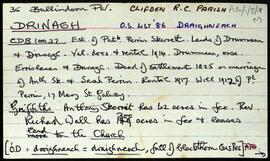
Set of index cards describing some of the local features of the townland of Drinagh, [Draighneach]. Included are descriptions of the Protestant Church (some of the headstones are listed here, and a note that the graves of Walls and Heathers are located here), Lorgan, Crompán (on the 1843 estate map as John Lambert's), a note on Aster Development Ltd (Boat Builders), and Imleach (a drumlin). Local man Adrian O'Connell credited as being one local source of information.
UntitledDrinagh (Galway
2 Archival description results for Drinagh (Galway
Overview list of the following townlands within the Civil Parish of Ballindoon. Cards include an Irish and English language rendition of each of the placenames. The following townlands are included.Ailebrack [An Aill Bhreac], Ardagh [Ardach], Ballinaboy [Béal átha na Bá], Ballinaleama [Baile na Léime], Ballyconneelly [Baile Conaola], Beaghcaumeen [Beitheach Cháinín], Boolagare [An Bhuaile Ghéar], Bunowen Beg [Bun Abhann Beag], Callow [An Caladh], Creggoduff [Creig an Duibh], Curhownagh [Corrthamhnach], Derryeighter [Doire Íochtair], Derrigimlagh [Deirgimleach], Dolan [An Dólainn], Doothulla [Dumhaigh Shalach], Doonloughan [Dún Locháin], Drimmeen [An Droimín], Drinagh [Draighneach], Emlagharan [Imleach árann], Emlaghmore [Imleach mór], Foorglass [Fothair Ghlas], Keerhaun More [An Caorán Mór], Keerhaun North [An Caoran Thuaidh], Keerhaun South [An Caorán Theas], Knoc [An Cnoc], Leaghcarrick [An Liathcharraig], Lehid [Leithead], Mannin Beg [Manainn Bheag], Mannin More [Manainn Mór], Maum [An Mám], Munga [Na Monga], Pollrevagh [An Poll Riabhach], Shannanagower [Seanadh na nGabhar], Silverhill [Cnoc an Airgid], Slieveburke [Sliabh Búrca], and Truska [Troscaigh].
Untitled