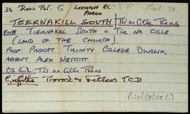
Copper mines

Elements area

Taxonomy

Code

Scope note(s)

    Source note(s)

      Display note(s)

        Hierarchical terms

        Copper mines

          Equivalent terms

          Copper mines

            Associated terms

            Copper mines

              3 Archival description results for Copper mines

              3 results directly related Exclude narrower terms
              Teernakill South
              UGA P/P120/1/8/25/1 · Item
              Part of Personal

              A set of index cards outlining briefly some of the local features of the townland of Teernakill South, [Tír na Cille Theas]. Included are descriptions of Binn Ramhar, Droichead an Easa (Shaughnessy's Bridge on the OS map), the Copper mines, a holy well, lake, and bridge, Tulachaí, Mám Aodha, Tír na Cille River, Aill na Lady, Corcóg, Log an tSamh, Bucán, Loigín Dóite, Meall, Binn Chaoinghí, Caobóg, Cúl an Easa, Na Cruic Breaca, and Binn Mhór. Will Crawford from Mám, Nora Keane, Mary Keane, Willy Sutcliffe, and a person identified as Lydon from Bun a Bhucáin are credited as being local sources of information.

              Robinson,Tim,Crawford,Will,Keane,Nora,Mary,Sutcliffe,Willy
              High Island
              UGA P/P120/1/6/34/1 · Item
              Part of Personal

              Set of index cards giving a description of the townland of High Island, [Ardoileán]. Included are a note on Richard Murphy, the poet, who bought High Island in the 1960's, and a general note on the terrain of the island itself. Also included are descriptions of The Chisters (two islets called Carrickarone on the OS maps), Dublin (a passage between cliffs), Fuagh na Cara, Fuagh an Mhianaigh, Promontory Fort, and the Copper Mine. A fisherman on the island provided some of the local information.

              Robinson,Tim
              An Cheathrú Gharbh
              UGA P/P120/1/8/5/1 · Item
              Part of Personal

              A set of index cards outlining some of the local features of the townland of An Cheathrú Gharbh, [Carrowgarriff]. Summary information from Griffith's Valuation, a note on the copper and lead mine used up until approximately the 1910's until it flooded out, a note on the Clement family who ran the lead mine during the 19th century, and a detailed note on Caisleán na Circe from the 13th century.

              Robinson,Tim