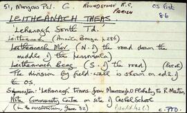
Set of index cards detailing some of the local features of the townland of An Cheathrú Rua Thiar [Carrowroe West]. Local features described include Bóthar na Scrathóg, Cuan na Loinge, Loch Each an Ghadaí, Loch an Tuairín, Cuan Tuairín, An tOileán Rua, An Crompán Carn, Loch Fhada, An Tamhnach, Tobar Maonh Thomais, Loch Bheag, Tuairín Mín, An Srutháin, Loch na Croimine, An Priosún (an islet west of Illaunroe, so called because it is easy to get caught there at high tide), and an tOileán Raithní. Peter McDonagh credited as being a local source of information.
Robinson,Tim,McDonagh,PeterBóthar na Scrathóg
2 Archival description results for Bóthar na Scrathóg
Set of index cards describing the physical features of Leitheanach Theas [Lehanagh South]. Some description about the demarcation between Leigheanach Mór, Beag, and on the translation of the place name. Features described include Cnoc an Aoire, Red Island, Barr na gCrompán, Loch Beag, Doire Mhian, Bun na Greallaí, Loch na Lurgan, Bun na Teorann, The General's Cora, Roisín (a small peninsula), Carraig an Ghlais, Cora Bhán, Caladh na Beirtrí, Gob an Chlochair, Aill Mhór, An Choill Bheag, Carraig na Sruthair, Loch Sligeach, Mary's Island, Gob an Doirín, Tóin an Chnoic, Leitheanach Mór Hill (where Marconi had a mast), Loch na Meall Breac, Clochar an Bhrandy, Aill na Mallacht, Kingstreet, and Bóthar na Scrathóg (the bog road to Doire Iorrais). Some local people are credited with providing information, and these are named as Paddy Nee's son, Pete Lydon, Mike Cunningham, and Joe King of Roundstone.
Robinson,Tim,Lydon,Pete,Cunningham,Mike,King,Joe