Binn Mhór

Elements area

Taxonomy

Code

Scope note(s)

    Source note(s)

      Display note(s)

        Hierarchical terms

        Binn Mhór

          Equivalent terms

          Binn Mhór

            Associated terms

            Binn Mhór

              3 Archival description results for Binn Mhór

              3 results directly related Exclude narrower terms
              Kilmeelickin
              UGA P/P120/1/8/14/1 · Item
              Part of Personal

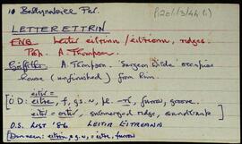
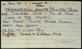
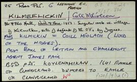
              A set of index cards outlining some of the local features of the townland of Kilmeelickin [Béal Átha na mBreac/Coill Mhíolcon]. Included are a note on the O'Malley family, a detailed note on the history of the Chapel from its construction in 1840. The note includes a list of clergy there until the early 20th century. Also included are a brief description of D'al a Choltair, Marfaigh (a hilside with a line of cliffs), Binn Mhór, Béal Átha na mBreac, and a beehive quern. Kevin Joyve of Recess, Paul Gosling, and Nora Keane of Mám are credited as providing some of the information gathered for this townland.

              Robinson,Tim,Joyce,Kevin,Gosling,Paul,Keane,Nora
              Letterettrin
              UGA P/P120/1/3/44/1 · Item
              Part of Personal

              Set of index cards describing some of the local features of the townland of Letterettrin, [Leitir Eitreann]. Included are descriptions of The Short River (Owengar on the OS), Illaunroe and the Lodge (which dates back to around the time of Griffith's Valuation), Aill Thomaisín Coyne, Binn Mhór, and Lough Fee. Festy Mortimer of Rosroe, and Delia McDonncha are credited with providing some of the local knowledge.

              Robinson,Tim,Mortimer,Festy,McDonncha,Delia
              Teernakill South
              UGA P/P120/1/8/25/1 · Item
              Part of Personal

              A set of index cards outlining briefly some of the local features of the townland of Teernakill South, [Tír na Cille Theas]. Included are descriptions of Binn Ramhar, Droichead an Easa (Shaughnessy's Bridge on the OS map), the Copper mines, a holy well, lake, and bridge, Tulachaí, Mám Aodha, Tír na Cille River, Aill na Lady, Corcóg, Log an tSamh, Bucán, Loigín Dóite, Meall, Binn Chaoinghí, Caobóg, Cúl an Easa, Na Cruic Breaca, and Binn Mhór. Will Crawford from Mám, Nora Keane, Mary Keane, Willy Sutcliffe, and a person identified as Lydon from Bun a Bhucáin are credited as being local sources of information.

              Robinson,Tim,Crawford,Will,Keane,Nora,Mary,Sutcliffe,Willy